Shielmartin Hill facts for kids
Quick facts for kids Shielmartin Hill |
|
|---|---|
| Cnoc Shíol Mhártain | |

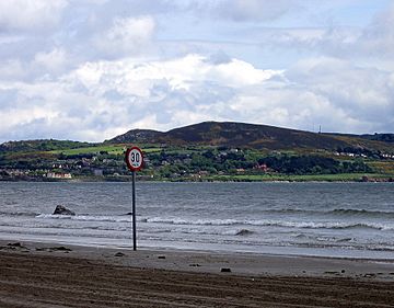
Shielmartin Hill is the hill to the right of the speed limit sign, viewed from the Bull Island in Dublin Bay.
|
|
| Highest point | |
| Elevation | 163 m (535 ft) |
| Naming | |
| Language of name | Irish |
| Geography | |
|
Lua error in Module:Location_map at line 420: attempt to index field 'wikibase' (a nil value).
|
|
| Location | Dublin, Ireland |
| Parent range | Wicklow Mountains |
| Topo map | OSi Discovery 50 |
Shielmartin Hill, also known as Shelmartin, is a cool peak on Howth Head in Dublin, Ireland. It stands about 163 metres (535 ft) tall. From the top, you can see amazing views! You'll spot places like Portmarnock, Sutton, and Bull Island. You can also see most of Dublin Bay stretching out below.
Contents
What Shielmartin Looks Like
If you look at Shielmartin Hill from Sutton Creek, it might seem like the top is split into two parts. But the real highest point is the one on the southern side. The other part, on the northern side, is actually a very old cairn.
What is a Cairn?
A cairn is a pile of stones built by people. This ancient cairn on Shielmartin Hill is believed to be a burial site. Local legends say it's where an old Irish king, Crimhthan Niadhnair, was buried long ago. Around this old cairn, some newer stone circles have been built.
How to Get to Shielmartin Hill
There's a special path that leads up Shielmartin Hill. A stone sign shows that the only official path goes down the northwest side of the hill. This is called a "right of way," meaning it's a public path you are allowed to use.
Paths and Safety
Other paths exist, but some can be tricky. For example, the path to the northeast is very steep and overgrown with plants, so it's not safe. There's also a safe route to the southeast, but it crosses the Howth Golf Course. Be careful if you use this path, and always respect golfers.
Around the Hill
Shielmartin Hill is mostly surrounded by the Howth Golf Course. This includes the areas to the west, north, and east. To the southwest, the hill meets Carrickbrack Road. You can find a path from this road that leads right up to the top. Private homes are located to the south of the hill.
Other Hills Nearby
Shielmartin Hill is sometimes mixed up with another spot called the Black Linn. The Black Linn is actually the highest point on the Howth peninsula. It's about 1 kilometre (0.6 mi) to the east of Shielmartin. Other hills close by include Dun Hill, Muck Rock (also known as Carrickmore), and Carrickbrack.
 | Percy Lavon Julian |
 | Katherine Johnson |
 | George Washington Carver |
 | Annie Easley |

