
Benham, Kentucky facts for kids
Quick facts for kids
Benham, Kentucky
|
|
|---|---|

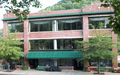
Benham City Hall
|
|
| Nickname(s):
The Little Town That International Harvester, Coal Miners, and Their Families Built
|
|

Location of Benham in Harlan County, Kentucky.
|
|
| Country | United States |
| State | Kentucky |
| County | Harlan |
| Incorporated | March 7, 1961 |
| Area | |
| • Total | 0.23 sq mi (0.61 km2) |
| • Land | 0.23 sq mi (0.61 km2) |
| • Water | 0.00 sq mi (0.00 km2) |
| Elevation | 1,591 ft (485 m) |
| Population
(2020)
|
|
| • Total | 512 |
| • Density | 2,188.03/sq mi (843.93/km2) |
| Time zone | UTC-5 (EST) |
| • Summer (DST) | UTC-4 (EDT) |
| ZIP code |
40807
|
| Area code(s) | 606 |
| FIPS code | 21-05662 |
| GNIS feature ID | 0486849 |
Benham is a small city in Harlan County, Kentucky, in the United States. It's known as a "home rule-class city," which means it has the power to manage its own local affairs. The city officially became a city in 1961. In 2020, about 512 people lived there, which was a small increase from 500 people in 2010.
Contents
History
How Benham Started
Benham began as a special kind of town called a company town. This means a company, in this case, International Harvester, built and owned most of the town. They did this to house their workers, especially coal miners, and their families.
Benham's Historic Recognition
The area known as the Benham Historic District is listed on the National Register of Historic Places. This is a special list that recognizes important places in history. It shows how important Benham was as a coal mining town.
Geography
Where is Benham Located?
Benham is in the eastern part of Harlan County. It sits in a valley, which is a low area between hills. This valley is formed by Looney Creek. To the north of the city is Looney Ridge, and to the south is Benham Spur. Looney Creek flows west and eventually joins the Poor Fork of the Cumberland River near Cumberland.
Roads and Mountains
Kentucky Route 160 is the main road in Benham, often called Main Street. If you go west on this road, you'll reach Cumberland, which is about 2.5 miles away. If you go east, you'll pass through Lynch and then reach the Virginia border. This road goes up Black Mountain, which is the highest point in Kentucky.
Size of the City
Benham is a small city in terms of land area. It covers about 0.6 square kilometers (or 0.23 square miles). All of this area is land, with no large bodies of water inside the city limits.
Population Information
How Many People Live Here?
The number of people living in Benham has changed over the years.
| Historical population | |||
|---|---|---|---|
| Census | Pop. | %± | |
| 1970 | 1,000 | — | |
| 1980 | 936 | −6.4% | |
| 1990 | 717 | −23.4% | |
| 2000 | 599 | −16.5% | |
| 2010 | 500 | −16.5% | |
| 2020 | 512 | 2.4% | |
| U.S. Decennial Census | |||
- In 1970, there were 1,000 people.
- By 2000, the population was 599.
- In 2010, it was 500 people.
- In 2020, the population grew slightly to 512 people.
Who Lives in Benham?
According to the 2000 census, there were 599 people living in Benham. Most residents were White (about 88.8%), and about 9.85% were African American. A small number of people were Native American or Asian.
The average age of people in Benham in 2000 was 44 years old. About 22.9% of the population was under 18 years old, and 19.5% were 65 years or older.
Environmental Concerns
Protecting Drinking Water
In 2010, people in Benham, including city workers, were worried about their drinking water. Many felt that Benham's water was very clean compared to other places nearby. However, there was concern that underground coal mining could make the public water supply dirty for both Benham and the nearby city of Lynch. This is an important issue for the health of the community.
Notable People
- Bernie Bickerstaff: A well-known executive and head coach in the NBA (National Basketball Association).
Gallery
-
Kentucky Coal Museum
-

Benham Schoolhouse Inn
-
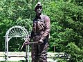
Coal Miner Statue


See also
 In Spanish: Benham (Kentucky) para niños
