Benjamin Banneker: SW-9 Intermediate Boundary Stone facts for kids
|
Benjamin Banneker: SW 9 Intermediate Boundary Stone
|
|

SW9 Boundary Stone (2012)
|
|
| Location | 18th and Van Buren Sts., Arlington and Falls Church, Virginia |
|---|---|
| Built | 1792 |
| NRHP reference No. | 76002094 |
Quick facts for kids Significant dates |
|
| Added to NRHP | May 11, 1976 |
| Designated NHL | May 11, 1976 |
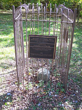
The Benjamin Banneker: SW 9 Intermediate Boundary Stone is a special marker stone. It helped show the original borders of Washington, D.C.. This stone is now on the border between Arlington County and the City of Falls Church in Virginia. You can find it inside the Benjamin Banneker Park.
This stone is named after Benjamin Banneker. He was a free African American astronomer. In 1792, he helped survey the land for the new District of Columbia. The stone became a National Historic Landmark in 1976. It was the first boundary marker from D.C. to be listed on the National Register of Historic Places.
Contents
What Does the Banneker Boundary Stone Look Like?
This boundary stone is made of sandstone. It is about 1 foot (0.3 meters) wide on each side. About 15 inches (38 centimeters) of the stone sticks out of the ground. The rest is buried, probably about 2 feet (0.6 meters) deep. The top of the stone is rounded and looks worn from age.
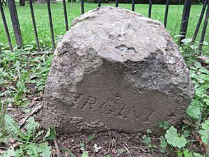
Over time, the stone has sunk a bit. This means some of the words carved into it are hard to see.
Messages on the Stone
The stone has special messages carved on its sides. On the side that faced the federal territory (now Arlington County), you can still see "Jurisdiction of the United States." This means it was part of the U.S. government's land.
On the opposite side, which now faces the City of Falls Church, you can see parts of the word "Virginia." This shows it was the Virginia side of the border.
One side of the stone has the year "1791" carved into it. The other side has a part of an inscription about the "Var." This stands for the magnetic variation of a compass needle. This was important for surveyors back then.
The Daughters of the American Revolution
In the early 1900s, a group called the Daughters of the American Revolution placed a brass marker on top of the stone. This marker is no longer there.
Who Was Benjamin Banneker?
Benjamin Banneker (1731-1806) was a very smart free African American man. He was a mathematician and an astronomer. In 1792, he helped Andrew Ellicott survey the original boundaries of the District of Columbia.
This stone is one of 40 markers that once outlined the District's borders. Benjamin Banneker had finished his work on the survey before this specific stone was placed.
 | William Lucy |
 | Charles Hayes |
 | Cleveland Robinson |


