
Bennachie facts for kids
Quick facts for kids Bennachie |
|
|---|---|

Mither Tap from the south
|
|
| Highest point | |
| Peak | Oxen Craig |
| Elevation | 1,732 ft (528 m) |
| Prominence | 1,037 ft (316 m) |
| Listing | Marilyn |
| Naming | |
| Language of name | Gaelic |
| Geography | |

Bennachie
Location in Scotland
|
|
| OS grid | NJ662226 |
| Topo map | OS Landranger 38 |
Bennachie (pronounced ben-ə-HEE) is a group of hills in Aberdeenshire, Scotland. It has several tops, or peaks. The highest one is called Oxen Craig, which is 528 meters (1,732 feet) tall.
Even though Bennachie is not the tallest mountain in Scotland, it stands out a lot. This is because the land around it is quite flat. So, you can see Bennachie from far away.
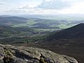
The peak that looks the most impressive is Mither Tap. It is 518 meters (1,699 feet) high. From its top, you can see great views of the area to the north and east. Most of the peaks form a long ridge from east to west.
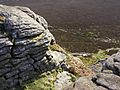
Millstone Hill (409 meters) is a bit separate from the main ridge. On top of Mither Tap, there is an Iron Age fort. This fort is very old, from a time long ago.
Contents
History of Bennachie
Some people think that Bennachie was a special place for ancient people. These were people from the Bronze Age who lived in the area. Many standing stones nearby support this idea. They might have thought the hill's shape was important.
Some historians also believe a famous battle, called the Battle of Mons Graupius, might have happened here. The name "Bennachie" itself might come from a Gaelic phrase meaning "hill of the battle."
The Bennachie Colony
From 1800 to 1859, a group of families lived on the east side of Bennachie. They were known as the Colony. These families were "squatters," meaning they lived on land they did not own.
They lived a simple farming life, often doing skilled jobs. They built stone walls and worked in quarries for local landowners. After 1859, the Colony slowly disappeared. This happened because the common land was divided up.
However, the last person from the original Colony, George Esson, lived on the hill until the 1930s. Today, visitors can explore the remains of the Colony. People are still working to learn more about the history of these families.
Ancient Alignments
Mither Tap has a special connection with an old Pictish fort called Caskieben. This fort is now part of Keith Hall. A poet named Dr. Arthur Johnston once said that the shadow of Bennachie reaches Caskieben during spring and autumn. This shows an interesting link between the hill and ancient sites.
Exploring Bennachie
Bennachie is a very popular place for people who love to walk. It is quite close to the city of Aberdeen. The Gordon Way is a marked path that goes along the south side of Bennachie. It runs between the Visitor Centre and Suie Car Park.
Most of the Bennachie hills are owned by Forestry and Land Scotland. They take care of many paths on and around the hills. They also manage several car parks and a visitor centre. The visitor centre is at the eastern foot of the hills.
A group of volunteers called the Bailies of Bennachie helps out. They started in 1973. They help maintain the paths and look after the environment and old sites on the hill. There are several marked paths for walkers. Some paths are easy and lead to Oxen Craig and Mither Tap from the visitor centre.
Images for kids
-
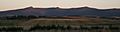
Bennachie from the North. Peaks are from left to right: Mither Tap, Craigshannoch, Bruntwood Tap, Oxen Craig, Watch Craig.
-
Oxen Craig from Mither Tap
-
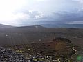
View north from Mither Tap
-
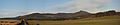
Bennachie viewed from the South, with the peak of Mither Tap to the right.
-
View from the summit of Mither Tap


