Bennett's Meadow Bridge facts for kids
Quick facts for kids Route 10 Bridge |
|
|---|---|
 |
|
| Coordinates | 42°41′00″N 72°28′18″W / 42.68333°N 72.47167°W |
| Carries | |
| Crosses | Connecticut River |
| Locale | Northfield, Franklin County, Massachusetts |
| Maintained by | MassHighway |
| ID number | N2200412EMHDNBI |
| Characteristics | |
| Design | Steel stringer/multi-beam or girder |
| Material | Steel (and concrete) |
| Total length | 215.5 metres (707.0 ft) |
| Width | 13.4 metres (44.0 ft) |
| Number of spans | 3 |
| Load limit | 57.5 Metric Tons |
| History | |
| Opened | 1969 |
| Statistics | |
| Daily traffic | 4,267 (2002) |
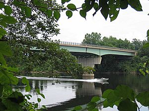
The Route 10 Bridge, also known as Bennett's Meadow Bridge, is a long steel bridge in Northfield, Massachusetts. It stretches 215.5 metres (707.0 ft) across the Connecticut River. This important bridge carries Route 10, a state highway. It was built in 1969 and helps many cars cross the river every day.
Contents
History of the Bridge
The story of the Route 10 Bridge is quite interesting. It's not the first bridge to stand in this spot!
The First Bridge (1810)
Back in 1810, the town of Northfield decided it needed a bridge. They gave permission for a bridge to be built near where the current one is now. A private company built this first bridge. The town even owned some shares in the company. Sadly, this bridge didn't last long. A big flood destroyed it after only a few years.
The Horse Boat Ferry
After the first bridge was gone, people still needed a way to cross the river. So, a special boat called Bennett's Meadow Ferry took its place. This ferry was pulled by horses and helped people and goods get from one side to the other.
The Second Bridge (1899)
Many years later, in 1897, the state government allowed Franklin County to build a second bridge. This new bridge was planned to be near the old ferry crossing. It cost about $35,000 to build.
A smart engineer named Edward Shaw from Boston designed this bridge. It opened for traffic in 1899. This bridge was special because it was built using a new method. Workers didn't need to use "false works," which are temporary supports that hold up bridge parts during construction. This new way of building bridges later became a standard method.
The Current Bridge (1969)
The 1899 bridge served its purpose for many years. However, it was eventually taken down. A third bridge, which is the one we see today, was then built. This current bridge was constructed just south of where the old one stood. Because of this, the highway (Route 10) was also slightly moved to connect properly to the new bridge. This modern bridge opened in 1969.
 | Dorothy Vaughan |
 | Charles Henry Turner |
 | Hildrus Poindexter |
 | Henry Cecil McBay |

