Bennington Village Historic District facts for kids
Quick facts for kids |
|
|
Bennington Village Historic District
|
|

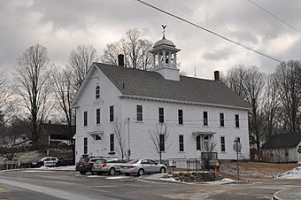
Bennington Town Hall
|
|
| Lua error in Module:Location_map at line 420: attempt to index field 'wikibase' (a nil value). | |
| Location | Antrim Rd, Main St, School St, Cross St, Grancestown Rd, South Bennington Rd, Acre St, Old Stagecoach Rd, Starrett Rd..., Bennington, New Hampshire |
|---|---|
| Area | 130 acres (53 ha) |
| Built | 1842 |
| Architectural style | Federal, Late Victorian |
| NRHP reference No. | 10000185 |
| Added to NRHP | April 19, 2010 |
The Bennington Village Historic District in Bennington, New Hampshire is a special area. It shows us what the village center was like in the 1800s. This area grew because of the paper industry. Papermaking is still a big part of the town's economy today. The district is found where Main, Center, and School Streets meet. It also includes Bible Hill Road and Francestown Road. This historic district was added to the National Register of Historic Places in 2010.
Bennington Village: A Historic Place
The area we now call Bennington Village started in the 1700s. Back then, it was part of Hancock. People called it "Hancock Factory." Around 1782, a man named Joseph Putnam built a sawmill and a gristmill here. He also built a bridge over the Contoocook River. The river's power helped run his mills and others that came later.
How Bennington Village Started
Bennington Village grew into its own busy industrial center. It officially became the town of Bennington in 1842. This happened when parts of Hancock and other towns joined together. More dams were built on the river during these years. A cotton mill and a paper mill also opened. In the second half of the 1800s, making cutlery (like knives and forks) became very important. By the mid-1900s, papermaking was the main industry. Today, the biggest mill building still standing is from the paper industry.
Important Buildings and Industries
The historic district is mostly on the east side of the Contoocook River. It stretches from a dam in the south to the Monadnock Mills paper plant in the north. The village center has a group of buildings formed by Cross Street, Main Street, and New Hampshire Route 31. From this center, roads spread out to other towns or run along the river.
The village has all of Bennington's main public buildings. This includes the town hall and the library. It also has the town's very first cemetery. The district also shows its industrial past. There are five dams on the river. An old power station from the early 1900s is also there. This station provided the first streetlights in the area!

