Bethel Township, Berks County, Pennsylvania facts for kids
Quick facts for kids
Bethel Township
|
|
|---|---|
|
Township
|
|

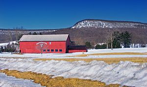
Round Top Valley Farm in Bethel Township
|
|
 |
|
| Country | United States |
| State | Pennsylvania |
| County | Berks |
| Area | |
| • Total | 42.33 sq mi (109.64 km2) |
| • Land | 42.22 sq mi (109.34 km2) |
| • Water | 0.12 sq mi (0.30 km2) |
| Elevation | 741 ft (226 m) |
| Highest elevation
(Blue Mountain, about 2 miles northeast of Shikellamy Scout Camp)
|
1,680 ft (510 m) |
| Lowest elevation
(Little Swatara Creek where it flows out of township)
|
430 ft (130 m) |
| Population
(2020)
|
|
| • Total | 4,072 |
| • Estimate
(2021)
|
4,066 |
| • Density | 97.62/sq mi (37.69/km2) |
| Time zone | UTC-5 (EST) |
| • Summer (DST) | UTC-4 (EDT) |
| Area codes | 610, 717 |
| FIPS code | 42-011-06008 |
Bethel Township is a community located in Berks County, Pennsylvania, in the United States. It is a type of local government area called a township. In 2020, about 4,072 people lived in Bethel Township.
Contents
A Look Back in Time
Important Buildings and Places
One special historical place in Bethel Township is the Spannuth Mill. This old mill was added to the National Register of Historic Places in 1990. This means it is recognized as an important historical site that should be protected.
Exploring Bethel Township's Land
Where is it Located?
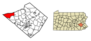
Bethel Township covers an area of about 42.2 square miles (109.6 square kilometers). Most of this area is land, with a very small amount of water. Water from the township flows into the Little Swatara Creek. This creek then joins the Swatara Creek and finally the Susquehanna River.
Natural Borders and Villages
The northern edge of the township is naturally formed by Blue Mountain. This mountain acts like a natural boundary. Inside Bethel Township, you can find several small villages. These include Bethel, Crosskill Mills, Frystown, Grimes, Meckville, and Schubert.
Neighboring Communities
Bethel Township shares its borders with several other townships:
- Upper Tulpehocken Township (to the east)
- Tulpehocken Township (to the south)
- Bethel Township, Lebanon County (to the west)
- Pine Grove Township, Schuylkill County (to the northwest)
- Washington Township, Schuylkill County (to the north)
- Wayne Township, Schuylkill County (to the northeast)
Fun and Nature in Bethel Township
Outdoor Activities
If you love the outdoors, you will find parts of the Pennsylvania State Game Lands here. These are areas set aside for wildlife and public recreation. Specifically, parts of Number 80 and Number 110 are in the township.
Hiking the Appalachian Trail
The famous Appalachian National Scenic Trail also passes through the northern part of Bethel Township. This long hiking trail stretches for thousands of miles. It is a great place for adventurers to explore.
Who Lives Here?
Population Over Time
| Historical population | |||
|---|---|---|---|
| Census | Pop. | %± | |
| 1980 | 3,312 | — | |
| 1990 | 3,576 | 8.0% | |
| 2000 | 4,166 | 16.5% | |
| 2010 | 4,112 | −1.3% | |
| 2020 | 4,072 | −1.0% | |
| 2021 (est.) | 4,066 | −1.1% | |
| Source: US Census Bureau | |||
In 2000, there were 4,166 people living in Bethel Township. These people lived in 1,466 households, with many of them being families. The population has stayed fairly steady over the years. In 2020, the population was 4,072 people.
Households and Families
About 35% of the households in 2000 had children under 18 years old. Most households (68%) were married couples living together. The average household had about 2.84 people.
Age Groups
The population in 2000 was spread out across different age groups. About 27% of the people were under 18 years old. Around 30% were between 25 and 44 years old. About 10% of the population was 65 years or older. The average age in the township was 36 years.
Getting Around Bethel Township
Roads and Highways
As of 2020, Bethel Township has about 95.82 miles of public roads. The Pennsylvania Department of Transportation (PennDOT) maintains about 38.21 miles of these roads. The township itself takes care of the remaining 57.61 miles.
Major Routes
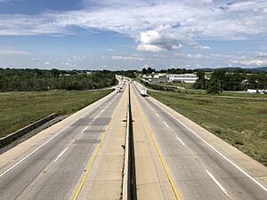
The main highway that goes through Bethel Township from west to east is Interstate 78/U.S. Route 22. This highway runs across the entire township. There are exits along this highway that connect to other important roads like Pennsylvania Route 645, Pennsylvania Route 501, and Pennsylvania Route 419. Pennsylvania Route 183 also briefly passes through the northeastern part of the township.
A Local Artist
The Sussel-Washington Artist
Bethel Township is known for a special artist called the Sussel-Washington Artist. This artist created a type of folk art called fraktur. Fraktur is a decorative style of writing and drawing, often seen in old documents and certificates. The artist's name is not known, but their works are connected to this community.
See also
 In Spanish: Municipio de Bethel (condado de Berks) para niños
 | Emma Amos |
 | Edward Mitchell Bannister |
 | Larry D. Alexander |
 | Ernie Barnes |


