
Bethungra, New South Wales facts for kids
Quick facts for kids BethungraNew South Wales |
|
|---|---|

Entering Bethungra
|
|

Bethungra
Location in New South Wales
|
|
| Population | 164 (2016 census) |
| Postcode(s) | 2590 |
| Elevation | 310 m (1,017 ft) |
| Location |
|
| LGA(s) | Junee Shire |
| County | Clarendon |
| State electorate(s) | Cootamundra |
| Federal Division(s) | Riverina |
Bethungra is a small place in Junee Shire in New South Wales, Australia. It is located in the South West Slopes region. You can find Bethungra on the Olympic Highway. It is about 13 kilometers northeast of Illabo. It is also 24 kilometers southwest of Cootamundra.
Contents
Bethungra's Past
How Bethungra Started
Bethungra officially began when its Post Office opened. This happened on December 1, 1875. It was an important step for the community.
The Bethungra Spiral
A very special railway feature is near Bethungra. It is called the Bethungra Spiral. This is a unique railway track shaped like a spiral. It was built to help trains climb hills more easily. This happened between 1941 and 1946. It is part of the Main South railway line.
Bethungra also had a railway station. It was open from 1878 until the 1980s. The station building has since been taken down.
A Railway Event
In 1885, a serious train accident happened near Bethungra. A train went off the tracks. This occurred because a culvert (a tunnel for water) had been washed away.
Special Places in Bethungra
What is Heritage-Listed?
When something is "heritage-listed," it means it is very important. It is protected because of its history or special features. Bethungra has some heritage-listed sites.
Important Sites to See
One of the most important heritage-listed sites is the Bethungra Spiral. It is part of the Main Southern railway.
Gallery
-
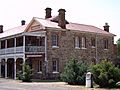
Bethungra Hotel, also known as Hotel Shirley
-
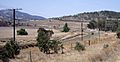
The unique Bethungra Spiral railway track
-
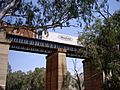
An overpass just south of the Bethungra Spiral


