
Beulah Valley, Colorado facts for kids
Quick facts for kids
Beulah Valley, Colorado
|
|
|---|---|

Entering the Beulah Valley from the east on Colorado State Highway 78.
|
|

Location of the Beulah Valley CDP in Pueblo County, Colorado.
|
|

Beulah Valley, Colorado
Location in the United States
|
|
| Country | |
| State | |
| County | Pueblo County |
| Government | |
| • Type | unincorporated community |
| Area | |
| • Total | 2.572 sq mi (6.662 km2) |
| • Land | 2.571 sq mi (6.660 km2) |
| • Water | 0.0008 sq mi (0.002 km2) |
| Elevation | 6,349 ft (1,935 m) |
| Population
(2020)
|
|
| • Total | 518 |
| • Density | 201.38/sq mi (77.75/km2) |
| Time zone | UTC-7 (MST) |
| • Summer (DST) | UTC-6 (MDT) |
| ZIP Code |
Beulah 81023
|
| Area code(s) | 719 |
| GNIS feature ID | 2407835 |
Beulah Valley is a small community in Pueblo County, Colorado, United States. It's known as a census-designated place (CDP). This means it's an area that looks like a town but doesn't have its own local government. Instead, it's managed by the county.
Beulah Valley is part of the larger Pueblo, CO Metropolitan Statistical Area. In 2020, about 518 people lived here. The local post office for the area is in Beulah, Colorado, with the Zip Code 81023.
Contents
Exploring Beulah Valley
Beulah Valley is a quiet place with beautiful natural surroundings. It's a great spot for people who enjoy the outdoors.
Geography and Size
The Beulah Valley CDP covers an area of about 6.66 square kilometers (or 1,646 acres). Most of this area is land, with a very small part being water. The valley is located in a scenic part of Colorado.
Population Over Time
The number of people living in Beulah Valley has changed over the years.
- In 2000, there were 1,164 residents.
- By 2010, the population was 556.
- In 2020, it was 518 people.
This shows that the community has become smaller over the last two decades.
Local Attractions
One of the most interesting places near Beulah Valley is Bishop Castle.
Bishop Castle
Bishop Castle is a truly unique building located between Beulah Valley and San Isabel, Colorado. It was built by one person, Jim Bishop, over many years. It's often called a "one-man castle" because of this. The castle features tall towers, stained glass, and even a dragon made of metal! It's a popular spot for visitors to explore and see what one person can create with dedication.
Images for kids
-
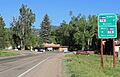
Entering the Beulah Valley from the east on Colorado State Highway 78.
-
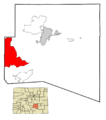
Location of the Beulah Valley CDP in Pueblo County, Colorado.
See also
 In Spanish: Beulah Valley para niños
