Bexley, New Zealand facts for kids
Quick facts for kids
Bexley
|
|
|---|---|
|
Suburb
|
|

Bexley Park
|
|
| Country | New Zealand |
| Local authority | Christchurch |
| Electoral ward | Linwood |
| Area | |
| • Land | 90 ha (220 acre) |
| Population
(June 2023)
|
|
| • Total | 2,680 |
|
|
||
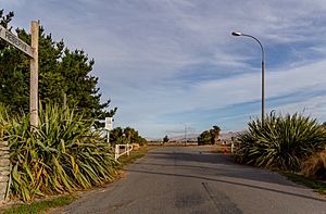
Bexley is a suburb in the eastern part of Christchurch, New Zealand. It sits on the west side of the Avon River / Ōtākaro. This river bends around Bexley, which is also close to the Avon Heathcote Estuary. The suburb of Aranui is right next to Bexley.
Contents
Where is Bexley?
Bexley is one of Christchurch's eastern suburbs. The Avon River forms its eastern edge. Important roads like Pages Road (north), Shuttle Drive (west), and Cuthberts Road, Breezes Road, and Bridge Street (south) mark its borders.
After the February 2011 earthquake, about 90% of homes in Bexley had to be pulled down. This was mainly because of something called liquefaction. Much of Bexley is now open green space for everyone to enjoy.
What is Bexley Like?
Bexley is well-known for its wetlands. These are areas of land that are often wet or covered in water. In recent years, some parts of these wetlands have been used for building houses. Other parts have been kept as special places for wildlife.
You can find many walking paths along the Avon River. There are also paths that go through the Bexley wetlands. These are great spots to explore nature.
Understanding Flood Risk
Bexley is in a high-risk flood zone. The Avon River can carry a lot of Christchurch's stormwater. Many areas in Bexley can be threatened by a mix of high tides and heavy rain. Because of this, new homes and big changes to older homes often need to be built higher off the ground.
Homes in Bexley
The houses in Bexley have different styles. Many were built from the early 1960s onwards. More recently, around the wetland areas, many new medium-sized bungalow-style houses have been built since the late 1990s.
Since the late 1970s, larger old properties have often been divided into smaller sections. This allows more homes to be built. This trend is expected to continue in the future.
Another change in Bexley is the connection of Anzac Drive and Bexley Road. This completes the Christchurch East Ring Road. This road helps connect the area to the port of Lyttelton.
Earthquake Impact
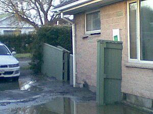
In the September 2010 earthquake, over 100 houses in Bexley became unlivable. This was due to silt and the ground sinking. This damage was caused by soil liquefaction. Liquefaction happens when the ground acts like a liquid during an earthquake.
In February 2011, the 2011 Christchurch earthquake caused more serious flooding. It also damaged roads and services. Again, this was due to soil liquefaction.
In June 2011, the government made an important announcement. They said that in some areas of Christchurch, including Bexley, the land was badly damaged. It was hard to know if repairs would work or how long they would take. So, the government offered to buy properties in these areas. They paid the value of the homes before the earthquakes. Bexley and other affected areas were then called part of Christchurch's residential red zone. This meant the land was too risky to rebuild on.
Who Lives in Bexley?
Bexley covers about 0.90 square kilometers. As of June 2023, , it had an estimated population of 2,680 people.
The 2018 New Zealand census showed that 2,553 people lived in Bexley. This was an increase from 2,244 people in 2013. The average age was 35.5 years old. About 20% of the people were under 15 years old.
Most people in Bexley are of European or Pākehā background (75.3%). There are also many Māori (24.8%) and Pasifika (13.0%) residents. Some people also identify as Asian (5.3%) or other ethnicities.
About 14% of people in Bexley were born outside New Zealand. Many people (54.5%) said they had no religion. About 32% were Christian.
 | Ernest Everett Just |
 | Mary Jackson |
 | Emmett Chappelle |
 | Marie Maynard Daly |


