Bhimber District facts for kids
Quick facts for kids
Bhimber
ضلع بھمبر
|
|
|---|---|

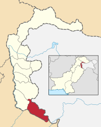
Map of Azad Kashmir with Bhimber highlighted
|
|
| Country | Pakistan |
| Established | 1996 |
| Area | |
| • Total | 1,516 km2 (585 sq mi) |
| Population
(1998)
|
|
| • Total | 343,000 |
| • Density | 232/km2 (600/sq mi) |
| Time zone | UTC+5 (PST) |
| Number of Tehsils | 3 |
| Website | http://www.bhimber.com |
Bhimber (Urdu: ضلع بھمبر) is a district located in the southern part of Azad Kashmir. It is one of the eight districts in this region of Pakistan. The main town in the district is also called Bhimber. This area covers about 1516 square kilometers.
Contents
Bhimber District: A Look at Azad Kashmir's Southern Gem
A Glimpse into Bhimber's Past
Bhimber has a very rich history. Many old buildings and artifacts have been found here. This is because of its important location. The powerful Mughal Emperors often traveled through Bhimber. They used this route to visit the beautiful Kashmir Valley.
For a long time, Bhimber was a smaller part of Mirpur District. These smaller parts are called tehsils. But in 1996, Bhimber Tehsil became its own separate district. This was an important step for the area.
Where is Bhimber Located?
Bhimber District is located in a key position. To its northwest, it shares a border with Mirpur District. The city of Mirpur is about 50 kilometers away. The Punjab province of Pakistan is to Bhimber's west and south. Bhimber also shares a border with Indian Kashmir to the east.
How Bhimber is Governed
The total area of Bhimber District is 1516 square kilometers. To help manage the district, it is divided into three smaller administrative areas. These areas are known as tehsils. Each tehsil has its own local administration.
Who Lives in Bhimber?
Many people call Bhimber District their home. According to a count in 1998, about 297,000 people lived there. By 1999, this number grew to an estimated 303,000. More recent figures suggest that around 350,000 people now live in the district.
The largest group of people in the region are the Jaats. The main language spoken by most people in Bhimber is Mirpuri.
 | Selma Burke |
 | Pauline Powell Burns |
 | Frederick J. Brown |
 | Robert Blackburn |

