Biberwier facts for kids
Quick facts for kids
Biberwier
|
||
|---|---|---|
 |
||
|
||
| Country | Austria | |
| State | Tyrol | |
| District | Reutte | |
| Area | ||
| • Total | 29.42 km2 (11.36 sq mi) | |
| Elevation | 989 m (3,245 ft) | |
| Time zone | UTC+1 (CET) | |
| • Summer (DST) | UTC+2 (CEST) | |
| Postal code |
6633
|
|
| Area code | 05673 | |
| Vehicle registration | RE | |
| Website | www.biberwier.tirol.gv.at | |
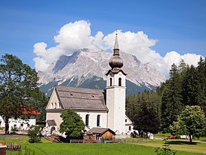
Biberwier is a small town in Austria. It is located in the Reutte District in the state of Tyrol. As of January 1, 2019, about 612 people live here. Biberwier is known for its beautiful mountain views and outdoor activities.
Contents
Where is Biberwier Located?
Biberwier is found in the Tyrolean Alps. It sits at the southern edge of the Lermooser Moos area. The village is nestled between a mountain slope and a unique landscape formed by a landslide near the Fern Pass.
Rivers and Mountains
The Loisach river flows through Biberwier. This river starts just west of the village. Biberwier is also close to the border with Germany. It is located near the Wetterstein Mountains. You can even see Biberwier from the top of the Zugspitze, which is Germany's highest mountain!
A Look at Biberwier's Past
The name Biberwier comes from the word "beaver." Beavers lived in this area until the 1800s. They have even returned to the area in recent years!
Ancient Roman Road
Biberwier was important a long time ago, during the Roman period. It was located on the Via Claudia Augusta. This was an ancient Roman road. Archeologists have found items from Roman times here. Some old track marks near the village are from the Middle Ages.
Mining History
From the Middle Ages until 1921, Biberwier was a big mining area. This was the largest mining operation in the Außerfern region. It was called "Gewerkschaft Silberleithen." Miners dug for silver, lead, and zinc ore.
Today, you can explore this old mining area. A special path called the Montan hiking trail Silberleithen opened in 2004. It helps visitors learn about the history of mining here.
Modern Transportation
In 1984, the Lermooser tunnel was built. This tunnel goes around the village. It helped reduce the amount of traffic passing directly through Biberwier. This made the village quieter and safer.
Biberwier is also part of a popular bicycle path. This path follows the route of the old Via Claudia Augusta Roman road.
Biberwier Today
Today, Biberwier is a popular place for tourists. It has a ski area called Marienbergjoch. There are also three beautiful swimming lakes: Blindsee, Mittersee, and Weißensee. This makes Biberwier a great place to visit in both summer and winter.
Biberwier's Coat of Arms
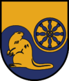
Biberwier has its own special symbol, called a coat of arms. It was given to the town in 1983.
What the Symbols Mean
The coat of arms shows a beaver. This represents the town's name. It also has a blue wheel. This wheel stands for the important transportation routes in the area. On the wheel, you can see a mallet and an iron. These are tools used in mining. They remind us of Biberwier's long history of mining. The colors of the town's flag are yellow and blue.
See also
 In Spanish: Biberwier para niños
 | Toni Morrison |
 | Barack Obama |
 | Martin Luther King Jr. |
 | Ralph Bunche |


