
Reutte District facts for kids
Quick facts for kids
Reutte District
Bezirk Reutte
|
|
|---|---|
 |
|
| Country | Austria |
| State | Tyrol |
| Number of municipalities | 37 |
| Area | |
| • Total | 1,236.37 km2 (477.37 sq mi) |
| Population
(2012)
|
|
| • Total | 31,758 |
| • Density | 25.6865/km2 (66.5277/sq mi) |
| Time zone | UTC+01:00 (CET) |
| • Summer (DST) | UTC+02:00 (CEST) |
The Reutte District is a special area, or district, located in Tyrol, Austria. It's like a county in some other countries. This district is sometimes called “Außerfern”.
It shares its northern border with Bavaria in Germany. To the south, it borders the Imst and Landeck districts. On its western side, you'll find the Bregenz and Bludenz districts, both of which are in Vorarlberg.
The Reutte District covers an area of about 1,236.37 square kilometers. As of 2012, about 31,758 people lived there. The main town and administrative center of the district is Reutte.
Contents
Exploring Reutte's Geography
This district has many interesting natural features. You can find several valleys, mountain ranges, and important lakes here.
Valleys and Passes
The Reutte District includes the beautiful Lech Valley, where the Lech River flows. Another notable valley is the Tannheimer Tal. There's also an area called Zwischentoren, which means "between the gates," located between the town of Reutte and the Fern Pass.
Mountain Ranges
Parts of several impressive mountain ranges are found within the district. These include sections of the Lechtal Alps, the Wetterstein Mountains, the Allgäu Alps, and the Tannheim Mountains. These mountains offer stunning views and opportunities for outdoor activities.
Important Lakes
The district is home to several important lakes. These include Plansee, Heiterwanger See, Haldensee, and Vilsalpsee. These lakes are often popular spots for visitors and locals alike.
Towns and Villages in Reutte
The Reutte District is made up of 37 different municipalities, which are like small towns or villages. Here is a list of them:
- Bach
- Berwang
- Biberwier
- Bichlbach
- Breitenwang
- Ehenbichl
- Ehrwald
- Elbigenalp
- Elmen
- Forchach
- Grän
- Gramais
- Häselgehr
- Heiterwang
- Hinterhornbach
- Höfen
- Holzgau
- Jungholz
- Kaisers
- Lechaschau
- Lermoos
- Musau
- Namlos
- Nesselwängle
- Pfafflar
- Pflach
- Pinswang
- Reutte
- Schattwald
- Stanzach
- Steeg
- Tannheim
- Vils
- Vorderhornbach
- Wängle
- Weißenbach am Lech
- Zöblen
Images for kids
-
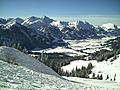
View on Tannheim in Tyrol
-

A robot, representing information for kids.


See also
 In Spanish: Distrito de Reutte para niños
