Imst District facts for kids
Quick facts for kids
Imst District
Bezirk Imst
|
|
|---|---|
 |
|
| Country | Austria |
| State | Tyrol |
| Number of municipalities | 24 |
| Area | |
| • Total | 1,724.65 km2 (665.89 sq mi) |
| Population
(2012)
|
|
| • Total | 57,734 |
| • Density | 33.4758/km2 (86.7019/sq mi) |
| Time zone | UTC+01:00 (CET) |
| • Summer (DST) | UTC+02:00 (CEST) |
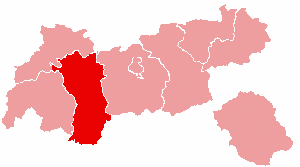
The Imst District is a special part of Tyrol, a state in Austria. It's like a county or a region. This district is known for its beautiful mountains and valleys.
It shares borders with other areas. To the north, it touches the Reutte District and even a small part of Bavaria in Germany. To the east, you'll find the Innsbruck-Land District. If you go south, it borders South Tyrol in Italy. And to the west, it's next to the Landeck District.
The Imst District covers a large area of about 1,724.65 square kilometers (665.9 square miles). This makes it the fourth largest district in Tyrol. In 2019, about 60,056 people lived there. The main town and administrative center of the district is Imst.
Towns and Villages in Imst District
The Imst District is made up of 24 different municipalities. These are like towns and villages that work together. Here are their names:
- Arzl im Pitztal
- Haiming
- Imst
- Imsterberg
- Jerzens
- Karres
- Karrösten
- Längenfeld
- Mieming
- Mils bei Imst
- Mötz
- Nassereith
- Obsteig
- Oetz
- Rietz
- Roppen
- Sankt Leonhard im Pitztal
- Sautens
- Silz
- Sölden
- Stams
- Tarrenz
- Umhausen
- Wenns
See also

- In Spanish: Distrito de Imst para niños
 | Claudette Colvin |
 | Myrlie Evers-Williams |
 | Alberta Odell Jones |

