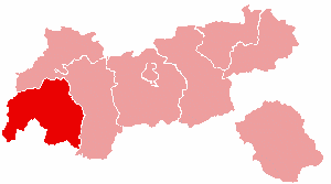
Landeck District facts for kids
Quick facts for kids
Landeck District
Bezirk Landeck
|
|
|---|---|
 |
|
| Country | Austria |
| State | Tyrol |
| Number of municipalities | 30 |
| Area | |
| • Total | 1,595 km2 (616 sq mi) |
| Population
(2015)
|
|
| • Total | 43,886 |
| • Density | 27.515/km2 (71.263/sq mi) |
| Time zone | UTC+01:00 (CET) |
| • Summer (DST) | UTC+02:00 (CEST) |
The Landeck District is a special area in Tyrol, Austria. Think of it like a county or region. It's located in the western part of Tyrol.
This district shares its borders with several other places. To the north, it's next to the Reutte District. To the east, you'll find the Imst District. South of Landeck, there are South Tyrol in Italy and Graubünden in Switzerland. To the west, it borders the Bludenz District in Vorarlberg.
The Landeck District covers an area of about 1,595 square kilometers. In 2015, around 43,886 people lived there. The main town and administrative center of the district is Landeck. This is where important offices and services for the district are located.
Towns and Villages
The Landeck District is made up of 30 different municipalities. A municipality is like a local government area. Out of these 30, one is a larger town, and the rest are smaller villages or communities.
The Main Town
The only town in the Landeck District is:
Other Municipalities
Here are the other villages and communities in the district:
- Faggen
- Fendels
- Fiss
- Fließ
- Flirsch
- Galtür
- Grins
- Ischgl
- Kappl
- Kaunerberg
- Kaunertal
- Kauns
- Ladis
- Nauders
- Pettneu am Arlberg
- Pfunds
- Pians
- Prutz
- Ried im Oberinntal
- Sankt Anton am Arlberg
- Schönwies
- See
- Serfaus
- Spiss
- Stanz bei Landeck
- Strengen
- Tobadill
- Tösens
- Zams
See Also
 In Spanish: Distrito de Landeck para niños
 | James Van Der Zee |
 | Alma Thomas |
 | Ellis Wilson |
 | Margaret Taylor-Burroughs |

