
Graubünden facts for kids
- The title of this article contains the character ü. Where it is unavailable or not wanted, the name may be written as Graubuenden.
Quick facts for kids
Kanton Graubünden
Chantun Grischun Cantone dei Grigioni |
||
|---|---|---|
|
||
 |
||
| Capital | Chur | |
| Subdivisions | 211 municipalities, 11 districts | |
| Area | ||
| • Total | 7,105 km2 (2,743 sq mi) | |
| Area rank | 1st | |
| Population
(2003)
|
||
| • Total | 185,700 | |
| • Rank | 15th | |
| • Density | 26.137/km2 (67.693/sq mi) | |
| Highest point | 4,049 m (13,284 ft) - Piz Bernina | |
| Joined | 1803 | |
| Abbreviation | GR | |
| Languages | German, Romansh, Italian | |
| Website | GR.ch | |

Graubünden is the largest and most eastern canton (like a state) in Switzerland. Its name means "Gray Union" in German. This canton is entirely in the Alps mountains. It is a very popular place for tourists, welcoming more visitors each year than any other canton in Switzerland.

Contents
Geography of Graubünden
Graubünden covers an area of about 7,105 square kilometers. Only about one-third of this land is used for farming. Forests cover 20% of the canton. Graubünden has many mountains. These mountains form the high areas of the Rhine and Inn river valleys. Many beautiful parts of the canton are protected. They are part of the Swiss National Park or the Ela Nature Park.
Mountains and Glaciers
The Grison Alps have many important peaks. These include the Tödi at 3,614 meters high. The highest peak is Piz Bernina, which stands at 4,049 meters. Many mountain ranges here have huge glaciers. You can find these in ranges like the Adula, Albula, and Bernina. The central mountains have some of Switzerland's deepest valleys.
Borders and Cities
Graubünden shares borders with several countries and cantons. To the north, it borders Liechtenstein and Austria. To the east, it also borders Austria. To the south, it borders Italy. Within Switzerland, it borders St. Gallen to the northwest. It also borders Glarus and the canton of Uri to the west. To the southwest, it borders Ticino.
The capital city of Graubünden is Chur. Other famous places include Davos and St. Moritz. These are well-known resorts around the world.
History of Graubünden
Most of the land in Graubünden was once part of a Roman area called Raetia. The Romans set up this province in 15 BC. Later, the area became part of the lands controlled by the diocese (church area) in Chur.
Forming the Leagues
In 1367, a group called the League of God's House was formed. They wanted to reduce the power of the Bishop of Chur. Then, in 1395, the Grey League was created in the Upper Rhine valley. People called it the Grey League because they wore simple grey clothes. The name of this league later gave the canton of Graubünden its name.
The different leagues started to join together. In 1450, the League of the Ten Jurisdictions joined with the League of God's House. By 1471, these two leagues also joined with the Grey League. This meant the leagues became allies with the Swiss Confederation. They fought against the Habsburgs and won important battles. These victories helped the Swiss Confederation and the allied leagues of Graubünden become recognized.
Becoming a Canton
The last parts of the Bishop of Chur's power ended in 1526. The Musso war in the 1520s brought the Three Leagues even closer to the Swiss Confederacy. The lands of Graubünden were part of the Helvetic Republic for a short time. Finally, in 1803, Graubünden officially became a canton of Switzerland. The canton's current rules for how it is run were set in 1892.
The coat of arms (symbol) of Graubünden today includes symbols from the three original leagues.
Modern Changes
Private cars were not allowed in Graubünden for a long time. People had to vote several times before cars were finally allowed in 1926.
Culture and Food
Graubünden is famous for some special foods. One is a dried-beef dish called Bündnerfleisch. Another is a sweet pie made with nuts and honey, known as Bündner Nusstorte. In the western part of Graubünden, people make Capuns. This is a filling meal with pasta and a little meat, rolled into Chard leaves. It is often baked like a gratin with cheese.
Economy of Graubünden
The economy of Graubünden mainly relies on farming and tourism.
Farming and Agriculture
Farming here includes forests and mountain pastures. In summer, farmers mostly raise beef cattle. They also raise sheep and goats.
Tourism
Tourism is very important all over the canton. Popular areas include Davos/Arosa, Flims, and St. Moritz/Pontresina. These places are busy in both winter and summer. Many other resorts also attract visitors to Graubünden.
Other Industries
There is wine production around the capital city of Chur. Chur is also a center for other industries. In the southern valleys of Mesolcina/Misox and Poschiavo, farmers grow corn (maize) and chestnuts.
Languages and Religions
Graubünden is special because it has three official languages. German is spoken in the northwest. Romansh is spoken in the Engadin valley and around Disentis/Mustér. Standard Italian is spoken in the valleys of Mesolcina/Misox, Calanca, Val Bregaglia, and Poschiavo.
The main religions in Graubünden are Protestantism and Catholicism. Both are common, with Roman Catholics making up a slightly larger group.
Districts of Graubünden
Graubünden is divided into 11 smaller areas called districts:
Municipalities of Graubünden
As of April 2004, Graubünden has 209 municipalities (smaller towns and villages):
Images for kids
-
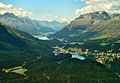
The Engadin valley, near St. Moritz and its lakes. It is one of the highest valleys in the Alps.
-
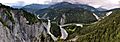
The Anterior Rhine river at the Rhine Gorge. It is one of the largest rivers in the canton.
-
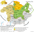
A map showing the Three Leagues and nearby lands in history.
-
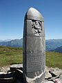
The Dreibündenstein monument. It marks where the three original leagues once met.
-
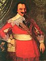
Jörg Jenatsch was an important person during a time of trouble in Graubünden (1618–1639).
-
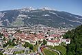
A view of Chur, the capital city, at the foot of the Calanda mountain.
-
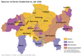
A map showing where different languages are spoken in Graubünden, as of 2000.
-
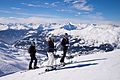
Skiers enjoying the slopes above Lenzerheide.
-
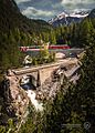
The Glacier Express train climbing the Albula Railway. Winding mountain roads and railways are a big part of the landscape here.
-
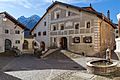
Beautiful painted houses and a wooden fountain in Guarda.
-
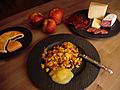
A dish of Maluns, a local specialty, served with other foods from Graubünden.


.jpg)


.jpeg)


See also
 In Spanish: Cantón de los Grisones para niños
