
Andiast facts for kids
Quick facts for kids
Andiast
|
||
|---|---|---|
 |
||
|
||

Andiast
Location in Switzerland

Andiast
Location in Canton of Graubünden
|
||
| Country | Switzerland | |
| Canton | Graubünden | |
| District | Surselva | |
| Area | ||
| • Total | 13.63 km2 (5.26 sq mi) | |
| Elevation | 1,178 m (3,865 ft) | |
| Population
(December 2020)
|
||
| • Total | 211 | |
| • Density | 15.48/km2 (40.09/sq mi) | |
| Postal code |
7159
|
|
| Surrounded by | Glarus Süd (GL), Pigniu, Rueun, Waltensburg/Vuorz | |

Andiast is a charming former village in the Surselva Region of the Swiss canton of Graubünden. It was once known as Andest until 1943.
Andiast is famous for its winter sports. It is located very close to the popular ski resorts of Waltensburg/Vuorz and Breil/Brigels.
On January 1, 2018, Andiast joined with the nearby village of Waltensburg/Vuorz. They both became part of the larger municipality of Breil/Brigels.
Contents
Andiast's Past: A Look at Its History

The area around Andiast has been home to people for a very long time. In 1962, archaeologists found proof that people lived here even in the Stone Age. The village was first mentioned in writing in the year 765. It appeared in a document as Andeste.
In 1526, Andiast became its own independent church parish. Before that, it was part of Waltensburg/Vuorz's parish. During the Protestant Reformation, many areas changed their religion. However, Andiast chose to remain Catholic, unlike its parent parish.
In 1799, the people of Andiast experienced the effects of the French Revolution wars. Soldiers from France and Russia passed through the Alps. These soldiers were very tired and hungry. Their journey through the Panixer Pass was difficult, and they needed supplies from the village.
Andiast's Coat of Arms: What It Means
A coat of arms is a special design that represents a town or family. Andiast's coat of arms shows a figure named St. Julitta. She is holding a sword and leading a child.
This design is important because it represents the village church. The church is dedicated to St. Julietta. The coat of arms also uses an old village seal as part of its design.
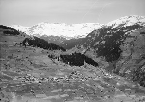
Andiast's Location and Landscape
Andiast covers an area of about 13.6 square kilometers (5.25 square miles). A large part of this land, about 42%, is used for farming. Forests cover another 26.8% of the area.
About 1.7% of the land has buildings or roads. The rest, nearly 30%, is made up of mountains, rivers, or glaciers. These parts are not used for farming or building.
Andiast is a "linear village." This means its buildings are spread out in a line, often along a road. It sits at an elevation of about 1,185 meters (3,888 feet). The village is located on the southern side of the Tödi mountain chain.
Andiast's People and Languages
Andiast has a population of about 150 people. A small part of the population, around 4.4%, are people from other countries. Over the last ten years, the number of people living in Andiast has gone down a bit.
Most people in Andiast speak Romansh. About 85.8% of the population uses this language. The second most common language is German, spoken by about 12.9% of the people. A very small number of people also speak French.
The people of Switzerland are generally well-educated. In Andiast, about 62.7% of adults have finished higher education. This includes university or special colleges called Fachhochschule.
Andiast has a very low unemployment rate, which means most people who want to work have jobs. In 2005, many people worked in farming. Others worked in manufacturing or service jobs like tourism.
The population of Andiast has changed over time. Here's how it looked in different years:
| Year | Population |
|---|---|
| 1850 | 242 |
| 1900 | 235 |
| 1950 | 309 |
| 2000 | 232 |
See also
 In Spanish: Andiast para niños
