St. Antönien facts for kids
Quick facts for kids
St. Antönien
|
||
|---|---|---|
 |
||
|
||
| Country | Switzerland | |
| Canton | Graubünden | |
| District | Prättigau/Davos | |
| Area | ||
| • Total | 52.28 km2 (20.19 sq mi) | |
| Elevation | 1,459 m (4,787 ft) | |
| Population
(Dec 2020 )
|
||
| • Total | 331 | |
| • Density | 6.331/km2 (16.398/sq mi) | |
| Postal code |
7246
|
|
| Localities | Ascharina, Castels, Rüti | |
| Surrounded by | Küblis, Luzein, Saas im Prättigau, Sankt Gallenkirch (AT-8), Schiers, Tschagguns (AT-8) | |
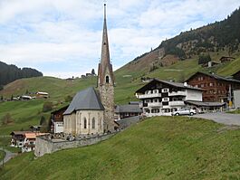
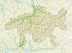
St. Antönien is a village in Switzerland. It's located in the Prättigau area, in the Graubünden canton. It used to be its own municipality, but now it's part of a larger one.
On January 1, 2007, two smaller towns, St. Antönien and St. Antönien Ascharina, joined together to form a bigger St. Antönien. Later, on January 1, 2016, this larger St. Antönien became part of the municipality of Luzein.
Contents
History of St. Antönien
St. Antönien was first written about in 1451. Back then, it was called Sant Anthonyen.
Long ago, people who spoke Romansh lived and worked in the lower parts of the valley. You can still see their influence in some place names. Around the year 1400, a group of people called the Walser arrived. They came from the Klosters area. They were allowed to settle in the higher parts of the valley first. Over time, they moved down into the lower areas. The Walser also brought their special style of house building. Their houses used more wood and less stone than other local buildings.
Geography and Location
St. Antönien covers an area of about 52.2 square kilometers (20.2 sq mi). Some of its settlements are quite high up, reaching around 1800 meters (5,900 ft) in places like Gafia and Partnun.
- About 51.6% of the land is used for farming.
- Around 11.4% is covered by forests.
- Only 0.9% has buildings or roads.
- The remaining 36.1% is made up of things like rivers, glaciers, or mountains.
The village of St. Antönien is part of the Luzein sub-district. It was formed in 1979 when two smaller areas, St. Antönien Castels and St. Antönien Rüti, joined together. Then, in 2007, St. Antönien Ascharina also became part of St. Antönien.
Tourism and Activities
St. Antönien has been a small tourist spot since 1891. Back then, about 30 to 40 visitors would stay in homes that were empty during the summer. This was because local people moved their animals to higher pastures, a practice called summer pasturing.
Today, you can find hotels and about 20 rental properties with around 500 beds. Ski slopes opened in 1974 with the Skilift Junker. In the 1980s, the village had a record 50,000 guest nights per year. This number has dropped to about 30,000 in the 2000s.
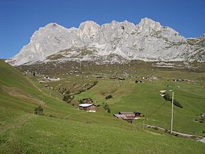
The valley is famous for mountain climbing. It has impressive limestone peaks from the Rätikon mountain range. The nearby Sulzfluh mountain has a special climbing route called a Via Ferrata on its south side, which opened in 2005.
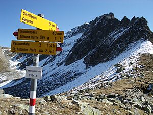
People who don't climb can still enjoy the mountains. They can go skiing, ski touring, or hiking along the beautiful Rätikon range. Even though some parts look very steep, it's possible to reach certain mountain tops on hiking paths without needing special climbing gear.
Important Buildings
The House with Barn at Berawis 68 is a very important building. It is listed as a Swiss heritage site of national significance. This means it's a special place that is protected because of its history and value.
Population and Community
St. Antönien has a population of 331. A small part of the population, about 4.0%, are foreign nationals. Over the last ten years, the number of people living here has slightly decreased.
- Most people (97.7%) speak German.
- Albanian is the second most common language (1.4%).
- Romansh is spoken by a small number of people (0.3%).
In 2000, the population was almost evenly split between males (51.9%) and females (48.1%).
The age groups in St. Antönien are:
- Children (0-9 years old): 19.1%
- Teenagers (10-19 years old): 10.4%
- Young adults (20-29 years old): 8.7%
- Adults (30-39 years old): 17.4%
- Adults (40-49 years old): 13.0%
- Adults (50-59 years old): 11.7%
- Seniors (60-69 years old): 8.3%
- Seniors (70-79 years old): 10.4%
- Seniors (80-89 years old): 0.9%
In the 2007 national election, the most popular political party was the SVP. They received 58.4% of the votes. Other popular parties included the FDP (29.8%) and the SP (7.7%).
About 48% of the adults in St. Antönien (aged 25–64) have finished either higher secondary education or gone on to university or a specialized college (a Fachhochschule).
St. Antönien has a very low unemployment rate of 0.2%. This means almost everyone who wants a job has one.
- In 2005, 89 people worked in the primary economic sector, which includes farming and forestry. There were 34 businesses in this area.
- 8 people worked in the secondary sector, which includes manufacturing and construction. There were 3 businesses here.
- 57 people worked in the tertiary sector, which includes services like tourism and shops. There were 18 businesses in this sector.
The population of St. Antönien over the years:
| Year | Population |
|---|---|
| 1850 | 224 |
| 1900 | 255 |
| 1950 | 284 |
| 1970 | 229 |
| 2000 | 230 |
See also
 In Spanish: Sankt Antönien para niños
 | Sharif Bey |
 | Hale Woodruff |
 | Richmond Barthé |
 | Purvis Young |


