
Lumbrein facts for kids
Quick facts for kids
Lumbrein
|
||
|---|---|---|
 |
||
|
||

Lumbrein
Location in Switzerland

Lumbrein
Location in Canton of Graubünden
|
||
| Country | Switzerland | |
| Canton | Graubünden | |
| District | Surselva | |
| Area | ||
| • Total | 37.86 km2 (14.62 sq mi) | |
| Elevation | 1,405 m (4,610 ft) | |
| Population
(Dec 2011)
|
||
| • Total | 363 | |
| • Density | 9.588/km2 (24.83/sq mi) | |
| Postal code |
7148
|
|
| Surrounded by | Obersaxen, Sankt Martin, Sumvitg, Vals, Vignogn, Vrin | |

Lumbrein was a small town, also called a municipality, in the Swiss canton of Graubünden. It was located in the Surselva district. On January 1, 2013, Lumbrein joined with seven other towns. These towns were Cumbel, Degen, Morissen, Suraua, Vignogn, Vella, and Vrin. Together, they formed a new, larger municipality called Lumnezia.
Contents
History of Lumbrein
People have lived in the Lumbrein area for a very long time. The Crestaulta hill, near the small village of Surin, shows signs of life from the early Bronze Age. This was around 2000 to 1600 BC.
Lumbrein itself was first mentioned in a document from about 850 AD. However, this document is a copy made in the 1500s. The original paper is now lost. Later, in 1231, the town was called de Lumarins.
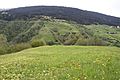
Geography and Landscape

Lumbrein covered an area of about 37.8 square kilometers (14.6 square miles) in 2006. A large part of this land, about 47%, was used for farming. Forests covered almost 24% of the area.
Only a small portion, about 1.5%, had buildings or roads. The rest of the land, about 27.6%, was made up of rivers, glaciers, or mountains. This shows that Lumbrein was a very natural and rural place.
The town was located in the upper part of the Lugnez valley. The main village of Lumbrein was about 1,405 meters (4,610 feet) above sea level. There were also several smaller villages, called hamlets, nearby. These included St. Andriu, Nussaus, Surin, Pruastg, and Silgin.
Coat of Arms
The coat of arms for Lumbrein was quite simple. It showed a green shield with a wavy silver stripe going down the middle. This design likely represented the natural features of the area, like its green landscapes and rivers.
People of Lumbrein
In 2011, Lumbrein had a population of 363 people. Over the ten years before that, the number of people living there had gone down by about 11.3%.
Most people in Lumbrein spoke Romansh, which is a local language in Switzerland. About 89.5% of the population spoke Romansh in 2000. German was the second most common language, spoken by about 8.3% of people. A small number of people, 0.8%, spoke Portuguese.
In 2000, the population was almost evenly split between males and females. About 12.3% of the people were children aged 0 to 9 years old. Teenagers, aged 10 to 19, made up about 14.3% of the population.
When it came to voting in the 2007 federal election, the most popular political party was the CVP. They received 63.6% of the votes. The SVP was next with 16.3% of the votes.
Many adults in Lumbrein had completed higher education. About 53% of people aged 25 to 64 had finished either advanced secondary education or university.
Most people in Lumbrein worked in farming. In 2005, 62 people worked in the primary economic sector, which includes farming. The secondary sector, like manufacturing, employed 28 people. The tertiary sector, which includes services, employed 45 people.
The population of Lumbrein changed over the years:
| year | population |
|---|---|
| 1850 | 529 |
| 1900 | 531 |
| 1930 | 475 |
| 1950 | 584 |
| 2000 | 399 |
Important Historical Sites
Lumbrein is home to some very important historical places. These are called heritage sites of national significance. This means they are very special and protected by the country.
- The Crestaulta and Cresta Petschna (Bronze Age settlements)
- The necropolis (ancient cemetery) at Surin
- A special "double house" at number 30
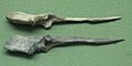
Crestaulta: A Bronze Age Settlement
Crestaulta is a very important Bronze Age site. It sits on a hill about 300 meters (980 feet) west of Surin. It was found in 1935 and dug up by archaeologists from 1935 to 1938.
Archaeologists found three main layers of settlement at Crestaulta.
- The bottom layer is from the early Bronze Age (around 2000-1700 BC). It showed simple huts with poles and places for animals.
- The second layer is from the middle Bronze Age (around 1700-1500 BC). Here, they found strong stone walls, animal stalls, a small round "cellar," and parts of a kiln (an oven for making pottery).
- The top layer is also from the middle Bronze Age (around 1500-1300 BC). It included another animal stall, a menhir (a tall standing stone), and a wooden floor.
Many ceramic pots were also found. These pots are now known as the Inner-alpine Bronze Age culture style.
Cresta Petschna: An Ancient Cemetery
In 1947, an ancient cemetery, or necropolis, was found near the Cresta Petschna river. This was about 150 meters (490 feet) from Crestaulta.
Archaeologists found at least 11 graves from the early Bronze Age. The items buried in these graves showed they belonged to women. They found things like sewing needles, pendants (jewelry worn around the neck), and arm rings.
-
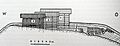
Buildings on the Crestaulta
-
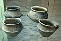
Ceramics from Crestaulta
-
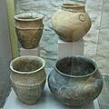
Ceramics from Crestaulta
-
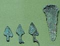
Spearheads from Crestaulta
-
Needles from Crestaulta
-
Crestaulta site


See also
 In Spanish: Lumbrein para niños
