
Lumnezia facts for kids
Quick facts for kids
Lumnezia
|
||
|---|---|---|

Lumnezia
|
||
|
||

Lumnezia
Location in Switzerland

Lumnezia
Location in Canton of Grisons
|
||
| Country | Switzerland | |
| Canton | Grisons | |
| District | Surselva | |
| Area | ||
| • Total | 165.48 km2 (63.89 sq mi) | |
| Population
(Dec 2020 )
|
||
| • Total | 1,996 | |
| • Density | 12.062/km2 (31.240/sq mi) | |
| Postal code |
7142
|
|
| Localities | Peiden, Uors, Camuns, Tersnaus, Surcasti, Cumbel, Vella, Morissen, Vattis, Degen, Vignogn, Lumbrein, Vrin, Cons | |
| Surrounded by | Vals, Ilanz/Glion, Obersaxen Mundaun, Sumvitg, Medel, Blenio | |

Lumnezia is a beautiful valley and a municipality in the Surselva Region of Switzerland. It's located in the canton of Graubünden. On January 1, 2013, several smaller towns like Cumbel, Degen, Lumbrein, Morissen, Suraua, Vignogn, Vella, and Vrin joined together to form the new municipality of Lumnezia.
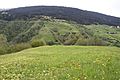
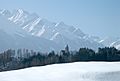
The area is known as the Val Lumnezia (which means Lugnez in German). It's a high alpine valley in Switzerland. Some of its highest parts are among the most remote places in the Swiss Alps. The main language spoken here is Romansh.
In 1998, the village of Vrin won the Wakker Prize. This award is given for protecting and preserving old buildings and the village's unique look.
Contents
History of Lumnezia
Ancient Times
Stone and Bronze Ages
Long, long ago, during the neolithic (New Stone Age) period, people likely lived in this valley. We know this because of a special rock called the Crap da Treis Siarps, or "Three Snakes Stone". This stone is part of a very old monument from the Stone or Bronze Age. You can find it on the side of the Glogn gorge, near the church of Pleif.
Even though other parts of the monument have worn away, the "Three Snakes Stone" is still clear. It has three snakes and a half-moon carved into it. This suggests it might have been a burial site or a place used to study the stars.
Roman Era
During the time of the Roman Empire, the Lumnezia valley was probably home to a Celtic tribe called the Helvetii. It was part of the Roman Province of Rhaetia. However, there aren't many Roman findings here. This is because the valley didn't have many natural resources, and crossing the Alps to Ticino was very difficult.
Middle Ages
Old stories from the early Middle Ages talk about Lumnezia. They mention its rich soil and good weather. In some protected areas, like Peiden, people even grew peaches and grapes. Around the 6th century AD, a church was built at Pleif, near Vella.
At this time, the valley became part of the Bishopric Chur. This meant the people living there were like servants to the bishops in Chur. Around 1200 AD, a German-speaking tribe called the Walsers settled in the Valser Valley. This valley is a side valley of Val Lumnezia.
Later, in the 14th century, the valley gained more freedom. It became part of the Grey League, which was a group of communities that worked together.
Reformation and Enlightenment
In 1538 AD, the people of Val Lumnezia bought their freedom from the feudal lords. This meant the local communities became independent. They could now make their own laws and manage their own economy. This was a big advantage because the valley could provide its own food and goods. People even traded cattle with cities as far away as Milan in Italy, crossing the Greina high plain.
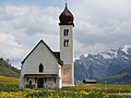
Around 1621 AD, the Holy See (the Pope's government) sent Capuchin monks to the area. They wanted to stop the spread of Protestantism, which was growing in Northern Switzerland. Because of this, Lumnezia is still mostly Roman Catholic today. You can see many beautiful baroque churches in the landscape.
Industrial Age and Modern Mergers
In 1890, a road was built to Ilanz for stagecoaches. This connected Lumnezia to the main Vorderrhein valley and the Swiss railway system.
Many of the smaller towns in Lumnezia have their own long histories:
- Cumbel was first mentioned around 825.
- Degen was first mentioned around 840.
- Lumbrein has ancient roots, with a hill called Crestaulta being settled since the early Bronze Age. The town itself was mentioned around 850.
- Morissen was first mentioned in 1210.
- Suraua was formed in 2002 by combining Camuns, Surcasti, Tersnaus, and Uors-Peiden. Each of these smaller places has its own history, some dating back to 831.
- Vignogn was first mentioned in 1325.
- Vella is a very old settlement, with signs of people living there in the late Bronze Age. It was mentioned around 840. Its church was once the main church for the whole valley. Vella became the most powerful village due to its religious importance.
- Vrin was first mentioned in 1208.
Geography of Lumnezia
After the 2013 merger, Lumnezia covers an area of about 165.43 square kilometers (63.87 sq mi). A large part of this land, about 44.8%, is used for farming. Forests cover 21.7% of the area. Only a small part, 1.4%, has buildings or roads, while 32.0% is unproductive land like mountains.
Geology and Landscape
Rocks and Mountains
The rocks in Val Lumnezia are mostly made of slate. This slate forms the mountains and valleys south of the Vorderrhein river. The slate layers are mixed with dolomite and quartzite. The Greina high Alpine plain is different, with crystallite rock formations. These are typical of the Adula Alps.
There are two main types of slate in Val Lumnezia. North of the Glogn river, you find slate from the Adula Alps. South of the Glogn river, you find Lugnez slate. The Adula slate has worn away a lot, but the Lugnez slate is stronger.
Glaciers and Ice Age Effects
The shape of Val Lumnezia today was created by a huge glacier. This glacier covered the entire valley about 26,000 to 13,000 years ago. As the glacier moved, it pushed away dirt and rocks. When it melted, it left behind a wavy layer of clay and gravel. This now forms the flat, terraced areas of Lumnezia.
The Piz Terri mountain and the high Greina plain are part of a nature reserve. The Kar Glacier below Piz Terri has shrunk a lot because of global warming. In 1865, this glacier filled the entire Lake Kar area. As it melted, the frozen ground (permafrost) thawed. This caused many rocks and gravel to fall, creating a huge landslide below Piz Terri. Other landslides have covered what's left of the glacier.
Rivers and Waterways
The river Glogn can be very powerful, especially during snowmelt or heavy rains. In the 1920s, it almost caused the village of Peiden to be evacuated because it was washing away the riverbanks. However, several dams and drainage systems have been built along its path to help control the water. Many smaller streams flow from the surrounding mountains. They have cut deep, narrow valleys into the terraced areas of Val Lumnezia.
Wildlife and Nature
Animals of Lumnezia
The animals in Lumnezia can be divided into those that live high in the Alps and those that live lower down. Above 1,500 meters (about 4,900 feet), you can often see marmots and chamois. The Alpine ibex also appears sometimes. Below that height, you might find foxes, hares, wild boars, and red deer. When winter comes, the chamois move down into the valley.
Sometimes, a brown bear might visit the lower parts of Val Lumnezia. This is because there's a bear sanctuary a few valleys over in Italy. Some caves and old buildings in the lower valley are home to the horseshoe bat. This is a special bat species that is protected.
In the higher and middle parts of the valley, several pairs of golden eagles have been brought back to live there.
Getting Around Lumnezia
Airports
The international airports at Zürich-Kloten and Milan Malpensa are both about the same distance from Lumnezia.
Trains
The closest train station is at Ilanz/Glion, in the valley of the Rein Anteriur river. The Rhaetian Railway line goes to Disentis/Mustér. From there, you can connect to the main Swiss railway network at Chur. Ilanz is also a stop for the famous Glacier Express train.
Roads
You can only reach Lumnezia by road using the Via Principala from Ilanz.
- If you're coming from Zürich or Chur, you'll take the Swiss Federal Highways A3 and A13(E43) towards the San Bernardino road tunnel. You exit at Reichenau. Then, follow Swiss National Road 19 to Ilanz. From Ilanz, take the Via Principala past Cumbel to Vella or Vals.
- If you're coming from Milan, you'll also exit the A13(E43) at Reichenau.
- If you're coming from Geneva, you can take the Swiss Federal Highways A1 and A9 (E62). Then, take the Furka Pass road, Swiss Federal Road 19, passing the Furka pass and the Oberalp Pass to Disentis. At Ilanz, leave Swiss Federal Road 19 for the Via Principala.
People of Lumnezia
Population Facts
Lumnezia has a population of about 2,150 people (as of December 2015). In 2013, about 3.6% of the people living here were foreign nationals. Between 2010 and 2013, the population decreased slightly.
As of 2013, children and teenagers (0–19 years old) make up 16.5% of the population. Adults (20–64 years old) are 58.0%, and seniors (over 64 years old) make up 25.5%.
Work and Jobs
In 2012, there were 944 people working in Lumnezia.
- About 300 people worked in farming and related businesses.
- 203 people worked in manufacturing and construction.
- 441 people worked in services, like shops, hotels, and healthcare.
In 2013, about 31.3% of the population received social assistance.
Things to Do and See
Skiing Adventures
Lumnezia has two main skiing areas:
- The Piz Mundaun
- The Piz Aul in the Valser Valley
There are also many ski-lifts on the northern side of the valley. These lifts connect Lumnezia to the Obersaxen ski area.
Places of Interest
Mountains to Explore
- Piz Terri
- Piz Aul
- Piz Mundaun
Nature's Beauty
- Glenner Gorge
- Alpine Forests
- Lake Kar
Important Historical Sites
Several places in Lumnezia are very important for Swiss history and culture. These are called "heritage sites of national significance":
- The Chapel of St. Sebastian in Degen.
- The Crestaulta and Cresta Petschna, which are ancient Bronze Age settlements and burial sites.
- The double house at number 30 in Lumbrein.
- The Church of S. Luregn/St. Lorenz in Suraua.
- The Church of S. Vincenz/St. Vincent in Vella.
- The Church of S. Maria in Vrin.
Crestaulta is a very important Bronze Age site on a hill near Surin. It was found in 1935. Scientists discovered three periods of settlement there. The oldest layer shows simple huts. Later layers show more solid stone walls, animal pens, and even a small "cellar" and parts of a kiln (an oven for pottery). They also found ceramic pots, which gave the name to the "Inner-alpine Bronze Age culture".
Near Crestaulta, a cemetery was found in 1947. It had at least 11 graves from the early Bronze Age. The items found in these graves, like sewing needles and arm rings, show they were women's graves.
The tower of the Church of S. Luregn/St. Lorenz in Suraua dates back to the 12th century. It was once a castle tower! When the family who owned it died out, it became a church tower. The church itself was rebuilt in a beautiful baroque style in 1774. During a restoration, a valuable statue of Mary was found.
The Church of St. Vincent in Vella is very old, first mentioned around 843. It was rebuilt in 1661-62 in a mix of Gothic and Romanesque styles.
The Church of the Immaculate Conception (St. Maria) and John the Baptist in Vrin was built in 1345. For a long time, it was a chapel under the main church in Vella.
-
Chapel of St. Sebastian
-
Buildings on the Crestaulta
-
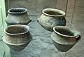
Ceramics from Crestaulta
-
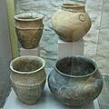
Ceramics from Crestaulta
-
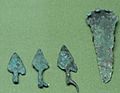
Spearheads from Crestaulta
-
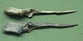
Needles from Crestaulta
-
Crestaulta site
-
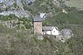
Formerly castle Surcasti, now Church of S. Luregn/St. Lorenz
-
Church of St. Vincent


Wakker Prize for Vrin
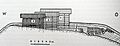
The village of Vrin received the Wakker Prize for how it blended new farm buildings with its old, traditional village look. This award recognized a long-term project in the village.
Throughout the 20th century, Vrin's population kept shrinking. In the 1980s and 1990s, the village worked with the local historic preservation group and a university (ETH Zürich). Their goal was to improve the village's facilities and help its population grow.
In the 1980s, the villagers bought all the empty land. This stopped people from buying land just to make prices go up. A local architect, Gion A. Caminada, was hired to guide the new construction.
They cleared meadows and brought in a butcher. A cooperative was started, and they built a slaughterhouse, barns, and a hall for many uses. Most of these new buildings were made of wood in a log cabin style.
Weather in Lumnezia
Weather in Vella
Vella usually has rain or snow for about 116 days each year. On average, it gets about 1,004 millimeters (39.5 inches) of precipitation. The wettest month is August, with about 115 mm (4.5 in) of rain or snow over 11.5 days. May has the most days of precipitation (11.7 days), but with less rain or snow (100 mm or 3.9 in). February is the driest month, with about 55 mm (2.2 in) of precipitation over 11.5 days.
Weather in Vrin
Vrin has rain or snow for about 121.1 days each year. On average, it gets about 1,143 millimeters (45.0 inches) of precipitation. August is the wettest month, with about 139 mm (5.5 in) of rain or snow over 12.7 days. July has the most days of precipitation (12.9 days), with about 131 mm (5.2 in) of rain or snow. February is the driest month, with about 59 mm (2.3 in) of precipitation over 12.7 days.
Famous People from Lumnezia
- Carmen Casanova: A women's Alpine Skier, born in 1980 in Vignogn.
Fun Events
- Open Air Lumnezia: A popular rock concert held in Degen.
