Obersaxen Mundaun facts for kids
Quick facts for kids
Obersaxen Mundaun
|
||
|---|---|---|

Obersaxen village
|
||
|
||

Obersaxen Mundaun
Location in Switzerland

Obersaxen Mundaun
Location in Canton of Graubünden
|
||
| Country | Switzerland | |
| Canton | Graubünden | |
| District | Surselva | |
| Area | ||
| • Total | 70.36 km2 (27.17 sq mi) | |
| Population
(Dec 2020 )
|
||
| • Total | 1,164 | |
| • Density | 16.543/km2 (42.847/sq mi) | |
| Postal code |
7134, 7137
|
|
| Localities | Obersaxen, Mundaun | |
| Surrounded by | Breil/Brigels, Degen, Lumbrein, Rueun, Sumvitg, Trun, Vella, Vignogn, Waltensburg/Vuorz | |

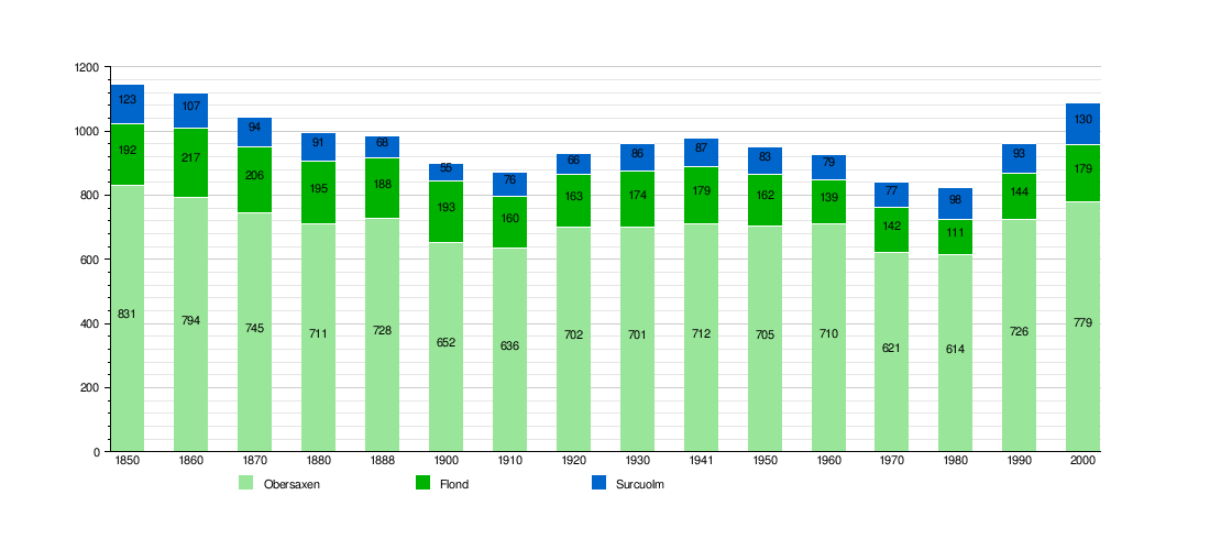
Obersaxen Mundaun is a special kind of town, called a municipality, located in the Surselva Region in the beautiful Swiss area of Graubünden. On January 1, 2016, two smaller towns, Obersaxen and Mundaun, joined together to create this new municipality.
Contents
History of Obersaxen Mundaun
How Obersaxen Began
The area known as Obersaxen was first mentioned in old writings way back in the year 765. At that time, a church leader named Bishop Tello gave his farms and fields there to a place called Disentis Abbey.
Later, in 806, it became a special "Imperial Estate," meaning it belonged directly to the emperor. This lasted until 956, when Emperor Otto I gave the village and its church back to the Bishop of Chur. The name "Obersaxen" was first written down as "Ubersahse" in 1227.
Who Settled Obersaxen?
The town you see today was started in the 1200s. A group of German-speaking people called the Walser moved to this high plateau. This is quite unique because Obersaxen is in the middle of the Surselva valley, where most people speak Romansh. So, Obersaxen is like a little island of German speakers!
The Story of Mundaun
Mundaun is a newer municipality. It was formed on January 1, 2009, when two smaller towns, Flond and Surcuolm, decided to merge into one.
Geography of Obersaxen Mundaun
Obersaxen Mundaun covers a large area of about 70 square kilometers. Imagine a big puzzle made of different types of land!
What the Land is Used For
A big part of the land, about 53.4%, is used for farming. This includes fields for crops and grassy areas where animals can graze. Another large section, about 24.9%, is covered by forests.
Only a small amount, about 2.4%, has buildings or roads. The rest, about 19.4%, is unproductive land, like rocky areas or high mountains.
Where is Obersaxen Mundaun Located?
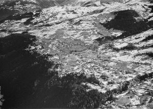
This municipality is found in the Surselva Region. It sits on the northern side of the Mundaun mountain range and the high plateau of Obersaxen. It's also south of the Vorderrhein river. You'll find many small, spread-out settlements all over the area.
Population of Obersaxen Mundaun
Obersaxen Mundaun is home to about 1,139 people.
How the Population Has Changed Over Time
The chart below shows how the number of people living in Obersaxen, Flond, and Surcuolm has changed over many years. You can see how the populations of these places grew or shrank before they became Obersaxen Mundaun.