
Disentis facts for kids
Quick facts for kids
Disentis/Mustér
|
||
|---|---|---|
 |
||
|
||

Disentis/Mustér
Location in Switzerland

Disentis/Mustér
Location in Canton of Grisons
|
||
| Country | Switzerland | |
| Canton | Grisons | |
| District | Surselva | |
| Area | ||
| • Total | 90.99 km2 (35.13 sq mi) | |
| Elevation
(Railway station)
|
1,130 m (3,710 ft) | |
| Population
(Dec 2020 )
|
||
| • Total | 2,009 | |
| • Density | 22.079/km2 (57.185/sq mi) | |
| Postal code |
7180
|
|
| Surrounded by | Linthal (GL), Medel (Lucmagn), Silenen (UR), Sumvitg, Tujetsch | |

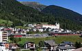
Disentis/Mustér is a charming village and municipality in the Grisons canton of Switzerland. It's known for its beautiful location high in the Rhine valley. This area is a popular spot for both skiing in winter and outdoor adventures in summer. Disentis/Mustér is also home to one of Switzerland's oldest Benedictine monasteries. The monastery was founded around 720 AD, and its impressive buildings you see today were built between 1696 and 1712.
Contents
A Look Back: The History of Disentis/Mustér

Disentis/Mustér has a long and interesting history. It was first mentioned in records in 765 AD as Desertina. Later, in 1127, it was called monasterium Dissertinensis. The name Disentis likely comes from the Latin word Desertina, meaning "deserted valley". The Romansh name, Mustér, simply means "monastery".
The monastery was founded around 720 AD. In the early Middle Ages, it became a very important place for culture and politics in the area that is now Grisons. Disentis was located on the road to the Lukmanier Pass, which was used by German emperors traveling to Italy. This made it a place of international importance during the High Middle Ages. The head of the monastery, called the prince abbot, was even the ruler of the Rhine valley.
Over time, the local farming communities became stronger, and the monastery's power lessened. However, the abbot of Disentis still played a key role in forming the Grey League in 1395. This was an important alliance of local communities.
When the Grey League officially joined forces with the Swiss Confederation in 1497, Disentis became strategically important again. It was at the foot of the Oberalp Pass, which was the closest connection to the Swiss Confederation. However, later on, other towns like Ilanz grew larger and became more important.
Exploring the Geography of Disentis/Mustér

Disentis/Mustér covers an area of about 91.1 square kilometers (about 35 square miles). A good portion of this land, about 21.8%, is used for farming. Forests cover 22% of the area. Only a small part, 1.8%, has buildings or roads. The rest, a large 54.3%, is made up of non-productive land like rivers, glaciers, and mountains.
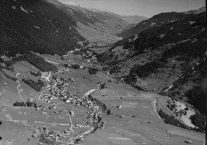
The municipality is the largest of seven villages in its sub-district and serves as its capital. It includes the main village of Mustér-Vitg and several smaller villages like Segnes, Acletta, and Disla. Disentis is located at a high point in the Rhine valley. It's where roads from the Oberalp Pass (connecting to central and western Switzerland) and the Lukmanier Pass (connecting to Ticino) meet.
Disentis has a train station that connects it to other parts of Switzerland. You can travel by train to the Valais region via the Oberalp Pass or follow the Rhine valley to Chur. During summer, a special post bus service also runs along the Lukmanier Pass road.
Culture and Language in Disentis/Mustér
Most people in Disentis/Mustér speak Romansh, which is a very old language spoken in parts of Switzerland. About 75.3% of the population speaks Romansh. German is the second most common language, spoken by about 20.4% of the people. The official language of the municipality is the Sursilvan dialect of Romansh. Even though many people also speak Swiss German and German, local laws are only written in Romansh.
Disentis is a very important center for the Romansh language, especially for the Sursilvan dialect. The high school at the monastery also plays a big role in preserving and promoting the local culture.
Fun for Visitors: Tourism in Disentis/Mustér

Tourism in Disentis/Mustér began around 1870. Today, it's a popular resort for many activities. In summer, you can explore over 150 kilometers (about 93 miles) of hiking trails. In winter, there are 30 kilometers (about 18 miles) of cross-country ski tracks. For those who love alpine skiing, there are 6 ski lifts that take you up to 2833 meters (about 9295 feet) high.
Disentis has 14 hotels and 21 restaurants. Together with the nearby municipality of Sedrun, the area offers about 10,000 beds in hotels and holiday apartments for visitors.
Important Historical Sites
Several places in Disentis/Mustér are considered very important national heritage sites. These include the Basilica of S. Gada, the famous Disentis Abbey, the Chapel of S. Luzi in Disla, and the Chapel of S. Maria in Acletta. The Punt Russein bridge, which is shared with the village of Sumvitg, is also a significant historical landmark.
Climate in Disentis/Mustér
Disentis/Mustér experiences a mountain climate. Summers are generally mild, with average high temperatures around 21.7°C (71°F) in July. Winters are cold, with average high temperatures around 2.6°C (37°F) in January. The area receives a good amount of precipitation throughout the year, with August being the wettest month. Snowfall is common in winter, with January seeing the most snow.
Population and Community
Disentis/Mustér has a population of about 2,111 people as of 2010. The population has seen a small decrease in recent years. The community is well-educated, with many adults having completed higher education.
Most people in Disentis/Mustér are Roman Catholic, making up about 90% of the population. A smaller percentage belongs to the Swiss Reformed Church or other Christian denominations.
Getting Around: Transportation
The municipality has four railway stations: Disentis/Mustér, Acla da Fontauna, Segnas, and Mumpé Tujetsch. The main station, Disentis/Mustér, is where two important railway lines meet. This allows for regular train services to places like Scuol-Tarasp, Zermatt, Andermatt, and St. Moritz.
Images for kids
-
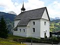
Chapel of S. Maria in Acletta
-
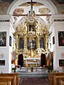
Chapel of S. Maria in Acletta, interior
-
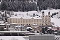
Disentis Abbey
-
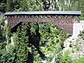
Punt Russein bridge (shared with Sumvitg)
-
Disentis Abbey, view from Via Lucmagn


