
Andermatt facts for kids
Quick facts for kids
Andermatt
|
||
|---|---|---|

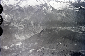
Andermatt looking west through the Urseren valley towards Hospental in front and the Furka Pass in the back (March 2005)
|
||
|
||

Andermatt
Location in Switzerland

Andermatt
Location in Canton of Uri
|
||
| Country | Switzerland | |
| Canton | Uri | |
| District | n.a. | |
| Area | ||
| • Total | 62.26 km2 (24.04 sq mi) | |
| Elevation
(Church)
|
1,437 m (4,715 ft) | |
| Highest elevation
(Pizzo Centrale)
|
2,999 m (9,839 ft) | |
| Lowest elevation
(Schöllenen)
|
1,289 m (4,229 ft) | |
| Population
(Dec 2020 )
|
||
| • Total | 1,527 | |
| • Density | 24.526/km2 (63.523/sq mi) | |
| Demonym(s) | German: Andermatter(in) | |
| Postal code |
6490
|
|
| Localities | Andermatt, Gurschen, Unteralp, Nätschen, Oberalp, Alp Rossboden | |
| Surrounded by | Airolo (TI), Göschenen, Gurtnellen, Hospental, Tujetsch (GR) | |

Andermatt is a mountain village and a municipality in the canton of Uri in Switzerland. A canton is like a state or province. Andermatt is high up, at 1,437 meters (4,715 ft) (about 4,715 feet) above sea level.
This village is right in the middle of the Saint-Gotthard Massif. This means it's at a historic meeting point for travel across Switzerland, both north-south and east-west. It's about 28 km (17 mi) (17 miles) south of Altdorf, which is the capital of Uri.
Contents
Exploring Andermatt's Location
Andermatt is found in the Urseren valley. This valley is where the Reuss River begins. The village is surrounded by the tall Adula Alps mountains.
How Rivers and Mountains Shape Andermatt
North of Andermatt, the Reuss River flows through a steep, narrow place called the Schöllenen Gorge. It then goes down the Reuss Valley and into the Urnersee, which is part of Lake Lucerne.
In other directions, three mountain passes connect the valley:
- The Oberalp Pass (2,044 meters or 6,706 feet) is to the east.
- The St Gotthard Pass (2,106 meters or 6,909 feet) is to the south.
- The Furka Pass (2,436 meters or 7,992 feet) is to the west.
What is Andermatt's Land Like?

Andermatt covers an area of about 62.2 km2 (24.0 sq mi). A large part, 40.8%, is used for farming. About 5.5% is covered by forests. Only a small part, 1.7%, has buildings or roads. The rest (52%) is made up of rivers, glaciers, or mountains.
Getting Around Andermatt
Andermatt is a very important place for travel. It connects southern Switzerland with the north. It also links eastern Switzerland (like Graubünden) with western Switzerland (like Valais and Bern).
Major Mountain Passes for Travel
The village is connected by three main mountain passes:
- The Oberalp Pass (2,044 meters or 6,706 feet) goes east to the Surselva region.
- The St Gotthard Pass (2,106 meters or 6,909 feet) goes south to the Valle Leventina.
- The Furka Pass (2,436 meters or 7,992 feet) goes west to the Obergoms area.
To the north, the steep Schöllenen Gorge connects Andermatt to Göschenen. This is where the famous Devil's Bridge is located. Andermatt has been on the important Gotthard Pass route since the Schöllenen route opened around the year 1200.
Train Travel in Andermatt
Andermatt has a train station run by the Matterhorn Gotthard Bahn (MGB). You can take a train from here to Brig and Visp. You can also go to Disentis/Mustér in Graubünden. There's also a short train line, the Schöllenenbahn, that connects Andermatt to Göschenen. This station is at the north end of the Gotthard Rail Tunnel.
Andermatt's Past: A Look at History
Archaeological finds show that the Urseren valley was settled as early as 4000 BC. This was during the Neolithic period, also known as the New Stone Age. Later, during Roman times, Celtic tribes likely lived here.
Early Settlements and Village Life
The first people to truly settle in the area where Andermatt is now were the Alemannic tribes and the Walsers. The village of Andermatt was first mentioned in records in 1203 as de Prato. In 1290, it was called A der Matte.
Famous Stories and Events

Near the Schöllenen Gorge, there's a monument. It remembers the 1799 military campaign of the Russian general Alexander Suvorov.
Between 1818 and 1831, the nearby St Gotthard Pass was made suitable for stagecoaches. This meant Andermatt became a busy stop before the pass. It grew and became a popular spa town.
The Impact of the Railway

However, things changed when the Gotthard Rail Tunnel opened in 1881. The tunnel goes right under the town, connecting Göschenen with Airolo. This made Andermatt less important for travelers, and its economy suffered.
Since 1885, Andermatt has been a military town for the Swiss Federal Army. It was built to be a command center in case of war. Today, it's a training center for the Swiss army.
Modern Changes and Growth
In the 1930s, tourism in Andermatt declined. Many hotels were left empty or used for other things. But around the year 2000, Andermatt became popular again. It offered a less expensive option than other ski resorts. The town has grown a lot since then, with many new buildings.
Who Lives in Andermatt?
Andermatt has a population of 1,527 people. About 10% of the people living here are from other countries. Over the last ten years, the population has gone down a little.
Languages and Jobs
Most people in Andermatt (95.2%) speak German. Portuguese is the second most common language, and Italian is third.
Many adults in Andermatt (about 75.2%) have finished high school or gone on to higher education, like university.
Andermatt has a low unemployment rate of 0.9%. Most people work in the service industry, like hotels and shops. Some work in farming or manufacturing.
| Year | Population |
|---|---|
| 1799 | 605 |
| 1850 | 677 |
| 1900 | 818 |
| 1950 | 1,231 |
| 1970 | 1,589 |
| 2000 | 1,282 |
| 2008 | 1,242 |
| 2010 | 1,304 |
| 2014 | 1,408 |
Andermatt's Weather and Climate
Andermatt gets a good amount of rain and snow. Between 1961 and 1990, it rained or snowed on average 147.3 days each year. The total amount of precipitation was about 1,422 mm (56.0 in).
Rain and Snow Patterns
April was the wettest month, with about 135 mm (5.3 in) of precipitation. May had the most days with rain or snow, but less total precipitation. February was the driest month.
Andermatt has a "Marine West Coast climate," which means it has mild summers and cool, wet winters.
| Climate data for Andermatt (1991–2020) | |||||||||||||
|---|---|---|---|---|---|---|---|---|---|---|---|---|---|
| Month | Jan | Feb | Mar | Apr | May | Jun | Jul | Aug | Sep | Oct | Nov | Dec | Year |
| Daily mean °C (°F) | −4.8 (23.4) |
−4.3 (24.3) |
−1.0 (30.2) |
3.0 (37.4) |
7.5 (45.5) |
11.0 (51.8) |
12.7 (54.9) |
12.6 (54.7) |
8.9 (48.0) |
5.2 (41.4) |
−0.1 (31.8) |
−3.9 (25.0) |
3.9 (39.0) |
| Mean daily minimum °C (°F) | −10.3 (13.5) |
−10.3 (13.5) |
−6.4 (20.5) |
−2.4 (27.7) |
1.8 (35.2) |
4.8 (40.6) |
6.7 (44.1) |
6.5 (43.7) |
3.2 (37.8) |
0.0 (32.0) |
−4.8 (23.4) |
−8.9 (16.0) |
−1.7 (28.9) |
| Average precipitation mm (inches) | 99 (3.9) |
91 (3.6) |
103 (4.1) |
108 (4.3) |
134 (5.3) |
131 (5.2) |
112 (4.4) |
134 (5.3) |
130 (5.1) |
125 (4.9) |
142 (5.6) |
112 (4.4) |
1,423 (56.0) |
| Average snowfall cm (inches) | 106 (42) |
111 (44) |
89 (35) |
65 (26) |
18 (7.1) |
1 (0.4) |
0 (0) |
0 (0) |
2 (0.8) |
25 (9.8) |
82 (32) |
111 (44) |
610 (240) |
| Average precipitation days (≥ 1.0 mm) | 11.2 | 10.3 | 11.5 | 11.5 | 12.9 | 13.2 | 12.3 | 12.7 | 10.4 | 10.2 | 11.8 | 11.4 | 139.4 |
| Average snowy days (≥ 1.0 cm) | 11.2 | 11.4 | 9.9 | 6.2 | 2.0 | 0.2 | 0.0 | 0.0 | 0.4 | 2.6 | 7.7 | 12.0 | 63.6 |
| Average relative humidity (%) | 75 | 75 | 74 | 72 | 73 | 75 | 75 | 77 | 77 | 75 | 77 | 77 | 75 |
| Source: MeteoSwiss | |||||||||||||
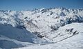
Skiing Adventures in Andermatt
Andermatt is a popular spot for skiing in winter. It has two main ski areas.
Exploring Andermatt's Ski Slopes
- Nätschen is a mountain on the north-east side of Andermatt.
- Gemsstock is a mountain on the southern side.
Both areas have ski lifts that take you up from the village. You can ski all the way down to the village until about mid-March. You can also reach Nätschen by train. There are plans to improve the ski areas and connect Nätschen with the slopes of Oberalp. The Oberalp slopes are currently only reachable by train, but they are part of the larger ski area.
Andermatt's mountains are well-known for their great off-piste (off the marked trails) and deep snow.
Fun and Entertainment in Andermatt
Andermatt has a special concert hall. It was the first building made just for arts performances in an Alpine village. The Berlin Philharmonic orchestra played there on its opening night.
Andermatt in Movies and TV
Andermatt has even appeared in famous media!
Andermatt on the Big Screen
The gas station Aurora, near the Gemsstock ski lift, was in the James Bond movie Goldfinger. Bond fills up his car there after a chase on the Furka Pass.
Andermatt on Television
In November 2012, Andermatt was featured on the British television show The Gadget Show. The presenters tested electric bicycles, scooters, and mobile phone photo editing apps on the hills of Nätschen.
Notable People from Andermatt
- Felix Maria Diogg (1762–1834), a famous portrait painter.
- Bernhard Russi (born August 20, 1948), a ski champion and Olympic Gold medalist.
Images for kids
-

Hotel Furkablick on the Furka Pass, east side
-
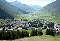
A view of Andermatt from Nätschen looking west through the Urseren towards Hospental in front below the Pizzo d'Orsino/Winterhorn (2661 m) and the Furka Pass (2429 m) in the back (August 2007)
-
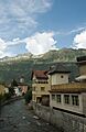
The Unteralpreuss flowing through Andermatt
-
Andermatt from Pazolastock/Piz Nurschalas (2739 m) looking west through the Urseren towards the Bernese Alps with the Finsteraarhorn (4274 m) in the middle
-
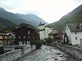
The Unteralpreuss flowing through Andermatt
-
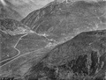
Andermatt by Eduard Spelterini, ca. 1903


See also
 In Spanish: Andermatt para niños
