Reuss (river) facts for kids
Quick facts for kids Reuss |
|
|---|---|

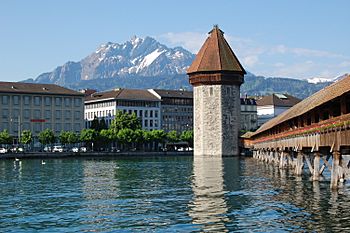
The Reuss at Lucerne
|
|
| Country | Switzerland |
| Cantons | Uri, Lucerne, Aargau |
| Settlements | Andermatt (UR), Göschenen (UR), Altdorf (UR), Lucerne (LU), Bremgarten (AG) |
| Physical characteristics | |
| Main source | Furkareuss, above Furka Pass, Uri 2,640 m (8,660 ft) 46°33′48″N 8°25′57″E / 46.56341°N 8.43259°E |
| River mouth | Aare at Windisch/Gebenstorf, Aargau 229 m (751 ft) 47°29′27″N 8°13′55″E / 47.4909°N 8.23193°E |
| Length | 164.4 km (102.2 mi) |
| Basin features | |
| Progression | Aare–Rhine–North Sea |
| Basin size | 3,426 km2 (1,323 sq mi) |
| Tributaries |
|
| Waterbodies | Lake Lucerne, Flachsee |
The Reuss is a major river in Switzerland. It flows for about 164 kilometres (102 mi), making it the fourth longest river in the country. Only the Rhine, Aare, and Rhône rivers are longer.
The Reuss river starts high in the canton of Uri. It flows through beautiful valleys and connects with the Aare river near Brugg. The area of land that drains into the Reuss is called its drainage basin, and it covers about 3,426 square kilometres (1,323 sq mi).
Contents
Where Does the Reuss River Start?
The Reuss river begins in the Swiss Alps. Its main source is the Furkareuss, which flows from above the Furka Pass. This area is very high up, at about 2,640 m (8,660 ft) above sea level.
The Upper Reuss: A Mountain Journey
As the river starts its journey, it flows through the Urseren valley. This part of the river is known as the upper Reuss. It carves out the main valley of the Uri canton. Along its way, it passes through towns like Andermatt and Göschenen.
The Schöllenen Gorge and Devil's Bridge
One famous part of the upper Reuss is the Schöllenen Gorge. This is a very narrow and deep canyon. To cross it, people built a famous bridge called the Teufelsbrücke, or "Devil's Bridge." It's an amazing example of old engineering.
The Reuss River's Path to Lake Lucerne
After its mountain journey, the Reuss river flows into Lake Lucerne. This large lake is a significant part of the river's course. Many smaller rivers, called tributaries, also flow into Lake Lucerne, adding to the Reuss's water.
Controlling the Water Flow
At the city of Lucerne, where the Reuss leaves the lake, there is a special structure called a Needle dam. This dam helps to control how much water flows out of Lake Lucerne into the lower Reuss river. It helps manage water levels in the lake.
The Lower Reuss: Flowing to the Aare
After leaving Lake Lucerne, the Reuss continues its journey north. This part is known as the lower Reuss. It passes through more towns and landscapes.
Joining the Aare River
Finally, the Reuss river meets the Aare river at a place called "Wasserschloss" near Windisch and Gebenstorf. The Aare is another big river in Switzerland. From there, the water from the Reuss continues with the Aare, then into the Rhine river, and eventually reaches the North Sea.
Images for kids
-
Teufelsbrücke in the Schöllenen Gorge
-
The Reuss near Gurtnellen
-
The Reuss entering Lake Lucerne
-
Rathaus-Steg at Lucerne
-
Needle dam regulating Lake Lucerne at Lucerne
-
Bridge of the Bremgarten-Dietikon-Bahn near Bremgarten
-
Confluence with the Aare at the "Wasserschloss"
See also
 In Spanish: Río Reuss para niños
 | John T. Biggers |
 | Thomas Blackshear |
 | Mark Bradford |
 | Beverly Buchanan |


