
Safien facts for kids
Quick facts for kids
Safien
|
||
|---|---|---|
|
|
||
|
||

Safien
Location in Switzerland

Safien
Location in Canton of Graubünden
|
||
| Country | Switzerland | |
| Canton | Graubünden | |
| District | Surselva | |
| Area | ||
| • Total | 100.6 km2 (38.8 sq mi) | |
| Elevation | 1,315 m (4,314 ft) | |
| Population
(Dec 2011)
|
||
| • Total | 294 | |
| • Density | 2.922/km2 (7.569/sq mi) | |
| Postal code |
7107
|
|
| Surrounded by | Casti-Wergenstein, Duvin, Flerden, Mathon, Nufenen, Pitasch, Portein, Präz, Riein, Sankt Martin, Sarn, Splügen, Sufers, Tenna, Tschappina, Vals | |
| Twin towns | Bettingen (Switzerland) | |


.jpg)

Safien was once a municipality in the Surselva district. It is located in the Swiss canton of Graubünden. On January 1, 2013, Safien joined with Valendas, Versam, and Tenna. Together, they formed a new, larger municipality called Safiental.
Contents
History of Safien
Safien is a very old place. It was first written about in the year 1219. Back then, its name was Stosavia.
Geography of Safien Valley
Safien covers a large area of about 100.6 square kilometers (38.8 square miles). A big part of this land, about 45.6%, is used for farming. Forests cover another 18.2% of the area.
Only a small part, 0.8%, has buildings or roads. The rest of the land, about 35.4%, is made up of rivers, glaciers, or mountains. This means much of Safien is natural and wild.
Safien was the main town in the middle and upper parts of the Safien valley. The Rabiusa river flows through this valley. The former municipality includes the main village of Safien-Platz, which is about 1,350 meters (4,429 feet) above sea level. There are also many small hamlets and single farmhouses spread out across the valley.
Safien's Coat of Arms
The coat of arms for Safien is quite simple. It has a red background. On top of the red, there is a cross made of silver and black triangles. This design is based on the older symbol for the sub-district, but with different colors.
Population and People
As of 2011[update], Safien had a population of 294 people. The number of people living in Safien has changed a lot over time. Here is how the population has grown or shrunk:
| year | population |
|---|---|
| 1803 | 770 |
| 1850 | 685 |
| 1900 | 455 |
| 1950 | 453 |
| 2000 | 308 |
| 2010 | 305 |
In 2008, only a very small part of the population, about 0.3%, were people from other countries.
In 2000, most people in Safien spoke Swiss German, about 96.1%. A smaller number spoke Swiss Italian (1.6%) or Albanian (1.6%). The population was almost evenly split between males (49.5%) and females (50.5%).
Looking at age groups in 2000, about 15.9% of the people were children aged 0-9 years. Teenagers (10-19 years) made up 14.0%. Adults aged 20-59 years made up about 44.2% of the population. Older adults and seniors (60-99 years) accounted for about 25.9% of the population.
Education in Safien
Many adults in Safien have a good education. About 61.7% of people aged 25 to 64 have finished advanced schooling. This includes either upper secondary education or higher education like university.
The closest universities of applied sciences (Fachhochschule) are in Chur. These include the Chur University of Applied Sciences and Fachhochschule Graubünden.
Economy and Jobs

.jpg)
In 2005, Safien had a very low unemployment rate of 0.46%. This means almost everyone who wanted a job had one. Most jobs in Safien are in farming.
The economy is divided into three main parts:
- The primary sector involves getting raw materials, like farming or forestry. In Safien, 89 people worked in this sector across 35 businesses.
- The secondary sector involves making things, like manufacturing. In Safien, 15 people worked in this sector in 3 businesses.
- The tertiary sector provides services, like shops or tourism. In Safien, 32 people worked in this sector in 12 businesses.
Images for kids
-
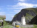
Thalkirch church in Safien
-
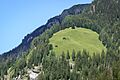
Mountain huts in Safien
-
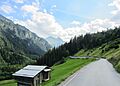
A farm shed on Safierstrasse
-
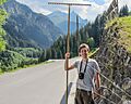
A farmer harvesting hay on Safierstrasse
-


.jpg)


See also
In Spanish: Safien para niños
