
Tschlin facts for kids
Quick facts for kids
Tschlin
|
||
|---|---|---|
 |
||
|
||

Tschlin
Location in Switzerland

Tschlin
Location in Canton of Graubünden
|
||
| Country | Switzerland | |
| Canton | Graubünden | |
| District | Inn | |
| Area | ||
| • Total | 75.08 km2 (28.99 sq mi) | |
| Elevation | 1,553 m (5,095 ft) | |
| Population
(Dec 2011)
|
||
| • Total | 442 | |
| • Density | 5.887/km2 (15.247/sq mi) | |
| Postal code |
7559
|
|
| Localities | Tschlin, Martina (includes Vinadi) and Strada (includes Chaflur) | |
| Surrounded by | Graun im Vinschgau (IT-BZ), Nauders (AT-7), Pfunds (AT-7), Samnaun, Spiss (AT-7) | |

Tschlin was once a municipality (like a town or local area) located in the Inn district in the far eastern part of Switzerland. It was part of the canton called Graubünden. On January 1, 2013, Tschlin joined with another municipality, Ramosch, to create a new, larger municipality named Valsot.
Contents
History of Tschlin Village

People have lived in the Tschlin area for a very long time. Archeologists have found items from the Bronze Age and Iron Age here. These are periods in history when people first started using metal tools.
The village of Tschlin was first mentioned in written records in the 10th century. Around that time, a religious leader named Bishop Hildibald gave a farm house in Tschlin as a gift to a chapterhouse (a group of clergy) in Chur.
During the High Middle Ages (a period from about 1000 to 1300 AD), Tschlin was under the control of the nearby area of Ramosch. The village church, called St. Blasius, was built in 1515. It was built in the Gothic style, which is known for its tall arches and detailed decorations.
In 1545, the Protestant Reformation reached Tschlin. This was a big religious movement that changed how many people practiced Christianity. From 1574 to 1582, a reformer and historian named Ulrich Campell worked in Tschlin.
Sadly, in 1856, a large fire destroyed much of the village. This included the Church of St. John the Baptist. The church was never rebuilt, but its old tower can still be seen in the village today.
Geography and Landscape of Tschlin

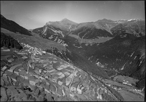
As of 2006, Tschlin covered an area of about 75.1 square kilometers (29 square miles). A large part of this land, about 28.7%, was used for farming. Forests covered another 34.7% of the area.
Only a small part, about 1.3%, was settled with buildings or roads. The remaining 35.3% of the land was made up of natural features like rivers, glaciers, or mountains.
The former municipality of Tschlin was located in the Ramosch sub-district, which is part of the Inn district. It included the main village of Tschlin, which sits on a flat area above the left bank of the Inn River. It also included the areas of Strada and Martina, along with smaller hamlets (very small villages) like San Niclà, Chaflur, Sclamischot, and Vinadi.
Before 1943, Tschlin was known by the name Schleins.
Population and People of Tschlin
Tschlin had a population of 442 people in 2011. As of 2008, about 6.3% of the people living there were foreign nationals, meaning they were from other countries. Over the ten years before 2011, the population grew slightly, by about 1.8%.
In 2000, the population was almost evenly split between males and females. About 49.6% were male and 50.4% were female.
Here's a look at the age groups in Tschlin in 2000:
- Children aged 0-9 made up 9.9% of the population (39 children).
- Teenagers aged 10-14 made up 6.9% (27 teenagers).
- Teenagers aged 15-19 made up 3.6% (14 teenagers).
- Young adults aged 20-29 made up 10.7% (42 people).
- Adults aged 30-39 made up 15.1% (59 people).
- Adults aged 40-49 made up 13.8% (54 people).
- Adults aged 50-59 made up 12.2% (48 people).
- Seniors aged 60-69 made up 9.4% (37 people).
- Seniors aged 70-79 made up 14.0% (55 people).
- Seniors aged 80-89 made up 4.1% (16 people).
- There was 1 person (0.3%) who was 90-99 years old.
In the 2007 federal election, the most popular political party in Tschlin was the SVP, which received 48.9% of the votes. Other popular parties included the SPS (20.8%), the FDP (14.3%), and the CVP (13.6%).
About 62.8% of the people in Tschlin aged 25–64 have completed higher education. This means they went to a university or a specialized college called a Fachhochschule.
Tschlin had a very low unemployment rate of 0.81%. In 2005, many people worked in farming (the primary economic sector). There were 62 people working in this area across 24 businesses. In the secondary sector (like manufacturing), 28 people worked in 8 businesses. The largest number of people, 101, worked in the tertiary sector (services like shops or tourism), with 21 businesses.
Historical Population Changes
The table below shows how the population of Tschlin has changed over many years:
| year | population |
|---|---|
| 1835 | 665 |
| 1850 | 571 |
| 1900 | 553 |
| 1930 | 648 |
| 1950 | 590 |
| 1960 | 553 |
| 1970 | 499 |
| 1980 | 431 |
| 1990 | 515 |
| 2000 | 392 |
| 2010 | 448 |
Languages Spoken in Tschlin
Most people in Tschlin speak Rhaeto-Romance, a special language spoken in parts of Switzerland. As of 2000, about 71.4% of the population spoke Rhaeto-Romance. German was the second most common language, spoken by 25.5% of the people. A small number of people (1.0%) spoke Serbo-Croatian.
The table below shows the number and percentage of people speaking different languages in Tschlin during three different census years:
| Languages | Census 1980 | Census 1990 | Census 2000 | |||
|---|---|---|---|---|---|---|
| Number | Percent | Number | Percent | Number | Percent | |
| German | 64 | 14.85% | 130 | 25.24% | 100 | 25.51% |
| Romanish | 362 | 83.99% | 313 | 60.78% | 280 | 71.43% |
| Italian | 4 | 0.93% | 33 | 6.41% | 3 | 0.77% |
| Population | 431 | 100% | 515 | 100% | 392 | 100% |
Important Heritage Sites
The Museum Stamparia da Strada in Tschlin is a very important place. It is listed as a Swiss heritage site of national significance. This means it's a special building or place that is important to the country's history and culture.
See also
 In Spanish: Tschlin para niños
