St Anton am Arlberg facts for kids
Quick facts for kids
Sankt Anton am Arlberg
|
||
|---|---|---|
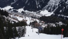
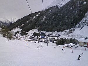
Sankt Anton am Arlberg in February 2016
|
||
|
||
| Country | Austria | |
| State | Tyrol | |
| District | Landeck | |
| Area | ||
| • Total | 165.81 km2 (64.02 sq mi) | |
| Elevation | 1,304 m (4,278 ft) | |
| Time zone | UTC+1 (CET) | |
| • Summer (DST) | UTC+2 (CEST) | |
| Postal code |
6580
|
|
| Area code | 05446 | |
| Vehicle registration | LA | |
| Website | www.stantonamarlberg.com | |
Sankt Anton am Arlberg, often called St Anton, is a small village and a famous ski resort in Tyrol, Austria. It sits high up in the Tyrolean Alps. You can take aerial tramways and chairlifts up to 2,811 m (9,222 ft) (about 9,222 feet) above sea level. This means you can ski down a huge vertical drop of 1,507 m (4,944 ft) (about 4,944 feet)! St. Anton is also a great place to visit in summer for hiking and mountain climbing.
Skiing has been important in St. Anton for a very long time. In the 1930s, ski instructors from this area even moved to the United States. They helped make skiing popular there. St. Anton hosted the Alpine World Ski Championships in 2001. It is often named one of the best ski resorts in the world. People love it for both its amazing skiing and its fun after-ski parties.
Contents
Geography of St. Anton
St. Anton is located next to the Rosanna River. It is also on the main train line that connects Austria and Switzerland. Many airports are close enough to reach St. Anton by train or car. These include airports in Munich, Zürich, Innsbruck, and Friedrichshafen. The center of the village is a special area just for people walking.
Fun Activities
Skiing Adventures
St. Anton is part of the larger Arlberg ski area. This huge region has 94 cable cars and ski lifts. It offers 340 km (210 mi) (about 211 miles) of prepared ski slopes. There are also 200 km (120 mi) (about 124 miles) of deep-snow runs for advanced skiers. You can use one special pass to access all of these areas.
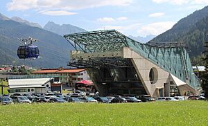
On the west side of the village, you'll find the "Galzigbahn." This is a modern gondola system. It has a unique "Ferris wheel" design. This allows people to get into the gondolas at ground level. Then, the gondolas rotate up to connect to the fast-moving cables. The Galzigbahn takes you to the Galzig slopes. From there, you can connect to the Schindler and Valluga peaks.
On the east side of town, the Nassereinbahn lift goes up to the Nasserein area. This area connects to the Kapall peak. The Kapall, Valluga, and Schindler peaks offer skiers nearly 1,500 vertical meters of skiing. After a day on the slopes, you can find fun after-ski bars right on the Steissbachtal trail, just above St. Anton.
The prepared ski runs in the Arlberg region are great for everyone. About 43% of the runs are easy (blue). About 41% are for intermediate skiers (red). The remaining 16% are for more advanced skiers (black). Plus, there are 200 km (120 mi) of deep snow runs for those who love off-piste skiing.
Expert Skiing Routes
For expert skiers, there are special ski routes that are not groomed very often. These include Schindlerkar and Mattun. There's also the back side of Valluga (2,811 metres or 9,222 feet). This route goes down to Zürs. However, only experts should try this route, and they must be with a guide. Many other off-piste routes are available for experts to explore with a local guide.
Other ski areas nearby include St. Christoph am Arlberg. This is a small village where, long ago, a shepherd built a shelter for travelers. There are also Stuben, Lech, Zürs, Warth-Schröcken, and Klösterle/Sonnenkopf.
Getting Around
Travel by Road
You can easily reach St. Anton by car using the A14 motorway. This highway runs from Vorarlberg, which is Austria's westernmost state. Vorarlberg shares borders with Liechtenstein and Switzerland. The motorway then follows the main valley of Tyrol.
Train Travel
St. Anton, Langen am Arlberg, and Kloesterle all have train stations. These stations are located in the Arlberg ski region. Both St. Anton and Langen am Arlberg are stops for international train services. These trains connect cities like Zurich and Budapest.
Local Bus Services
St. Anton and the villages around it have a good network of bus routes. In St. Anton itself, there are two main bus stops. They are called "Terminal Ost" and "Terminal West." "Terminal Ost" is close to the Nassereinbahn Gondola. "Terminal West" is near the Galzigbahn and Rendlbahn gondolas, as well as the train station.
There are frequent bus services all year round between St. Anton and Landeck. Landeck is a town at the start of the main valley, known locally as Stanzertal. Free bus services also run often within St. Anton itself. They also connect to nearby villages like Pettneu, Schnann, and Flirsch.
St. Anton Facts
Here are some interesting facts about St. Anton:
- Elevation: The village is at 1,304 m (4,278 ft) (about 4,278 feet). The highest point you can reach is 2,811 m (9,222 ft) (about 9,222 feet).
- Vertical Drop: You can ski down a total of 1,507 m (4,944 ft) (about 4,944 feet) from top to bottom.
- Longest Run: The longest ski run is 10.2 km (6.3 mi) (about 6.3 miles). It goes from Valluga all the way to St. Anton.
- Lifts: The Ski*Arlberg area has 94 lifts in total. This includes 11 gondolas, 51 chairlifts, and 32 T-bar lifts.
- Lift Capacity: The lifts can carry 151,010 people per hour!
- Ski Season: You can usually ski from early December until late April.
- Cross-country Skiing: There are 41 km (25 mi) (about 25 miles) of trails for cross-country skiing.
- Mountain Restaurants: You can find 18 restaurants on the mountains.
- Après-ski Fun: After skiing, you can visit the ski museum, 15 cafés, 8 ice bars, 3 discos, and 7 regular bars.
- Places to Stay: There are about 8,900 beds available in hotels, guesthouses, apartments, and private pensions in St. Anton, St. Jakob, and St. Christoph.
See also
 In Spanish: Sankt Anton am Arlberg para niños


