Roppen facts for kids
Quick facts for kids
Roppen
|
||
|---|---|---|
 |
||
|
||

Location in the district
|
||
| Country | Austria | |
| State | Tyrol | |
| District | Imst | |
| Area | ||
| • Total | 30.87 km2 (11.92 sq mi) | |
| Elevation | 724 m (2,375 ft) | |
| Time zone | UTC+1 (CET) | |
| • Summer (DST) | UTC+2 (CEST) | |
| Postal code |
6426
|
|
| Area code | 05417 | |
| Vehicle registration | IM | |
| Website | www.roppen.tirol.gv.at | |
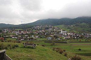
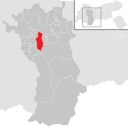
Roppen is a small town, also known as a municipality, in Austria. It is located in the Imst district in the state of Tyrol. Roppen is about 5 kilometers (3 miles) southeast of the town of Imst. It sits between the mouths of two rivers, the Pitze River and the Ötztaler Ache.
People have lived in the area where Roppen is now for a very long time, even as far back as 3000 years ago! The village was first officially mentioned in old documents in the year 1260. Back then, it was called "Roupen."
How Many People Live in Roppen?
This section shows how the number of people living in Roppen has changed over many years.
- What is Population?
The population of a place means the total number of people who live there. It helps us understand how a town or city grows or shrinks over time.
- Roppen's Population Over Time
You can see from the numbers below that Roppen has grown quite a bit over the years. For example, in 1869, there were 656 people living there. By 2011, the number had grown to 1644 people. This shows that more and more people have chosen to live in Roppen over the years.
| Historical population | ||
|---|---|---|
| Year | Pop. | ±% |
| 1869 | 656 | — |
| 1880 | 630 | −4.0% |
| 1890 | 592 | −6.0% |
| 1900 | 612 | +3.4% |
| 1910 | 647 | +5.7% |
| 1923 | 653 | +0.9% |
| 1934 | 728 | +11.5% |
| 1939 | 825 | +13.3% |
| 1951 | 883 | +7.0% |
| 1961 | 930 | +5.3% |
| 1971 | 1,118 | +20.2% |
| 1981 | 1,199 | +7.2% |
| 1991 | 1,390 | +15.9% |
| 2001 | 1,605 | +15.5% |
| 2011 | 1,644 | +2.4% |
See also
 In Spanish: Roppen para niños
 | Delilah Pierce |
 | Gordon Parks |
 | Augusta Savage |
 | Charles Ethan Porter |


