Billinudgel, New South Wales facts for kids
Quick facts for kids BillinudgelNew South Wales |
|||||||||
|---|---|---|---|---|---|---|---|---|---|

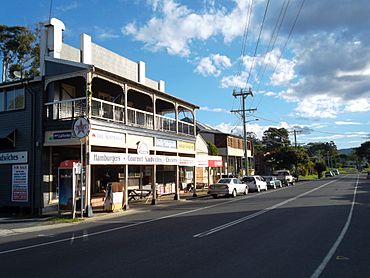
Shops in Wilfred Street—Billinudgel's main street
|
|||||||||
| Population | 261 (2021 census) | ||||||||
| • Density | 30.15/km2 (78.1/sq mi) | ||||||||
| Postcode(s) | 2483 | ||||||||
| Elevation | 2 m (7 ft) | ||||||||
| Area | 8.657 km2 (3.3 sq mi) | ||||||||
| Location | |||||||||
| LGA(s) | Byron Shire Council | ||||||||
| State electorate(s) | Ballina | ||||||||
| Federal Division(s) | Richmond | ||||||||
|
|||||||||
Billinudgel is a small town in the beautiful Northern Rivers area of New South Wales, Australia. It's part of the Byron Shire, a well-known region. A railway line used to run through Billinudgel, and a train station opened there in 1894. The Minjungbal people of the Bundjalung nation are the traditional owners of this land. They have lived here for a very long time.
Contents
What's in a Name?
The name Billinudgel comes from the Bundjalung language. It means "once belonged to a parrot" or "place of the king parrot." This suggests that many king parrots lived here. When Europeans first settled, they sometimes called it Billy Nudgel or Billy Mooghill.
A Look Back in Time
European settlement in Billinudgel started in the 1840s. The first settlers were mainly "cedar-getters." These were people who harvested and cut down cedar trees. They would float the cut timber down the Brunswick River. From there, it was shipped to Sydney.
The Railway Arrives
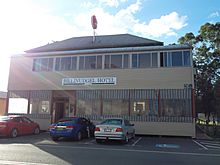
Building the Murwillumbah railway line began in 1884. Many workers came to the area for this project. Because of the new workers, the town's population grew. This led to the building of Billinudgel's first hotel. It was called The Tramway Hotel and opened in 1892. This hotel later burned down in 1898. After being rebuilt, it burned down again in 1906. In 1914, the hotel was renamed The New Brighton Hotel. Today, it is known as The Billinudgel Hotel.
School Days
The Billinudgel Public School also opened in 1893. It taught local children for many years. The school closed its doors in 1993.
Trains and Town Growth
Work on the railway line in Billinudgel finished in December 1894. The Billinudgel railway station was completed then. After the railway was built, some people moved away. However, the railway also brought new jobs. It made it easier to transport goods from the area. Many local farmers started dairy farming. From the 1920s, they also began growing bananas.
The Billinudgel railway station closed on 11 November 1980. This happened because fewer people were using the train.
Gallery
 | Jewel Prestage |
 | Ella Baker |
 | Fannie Lou Hamer |


