Brunswick River (New South Wales) facts for kids
Quick facts for kids Brunswick River |
|
|---|---|

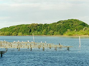
Littoral rainforest & oyster farm at Brunswick Heads, Australia. The rainforest features a large Ficus macrophylla in the left centre
|
|
|
Location of the Brunswick River mouth in New South Wales
|
|
| Native name | Durangbil (undetermined) |
| Other name(s) | Middle Arm of Brunswick River Main Arm of Brunswick River |
| Country | Australia |
| State | New South Wales |
| IBRA | NSW North Coast |
| District | Northern Rivers |
| LGA | Byron |
| Physical characteristics | |
| Main source | Mount Jerusalem Palmwoods, near Uki 141 m (463 ft) |
| River mouth | Coral Sea, South Pacific Ocean Brunswick Heads 0 m (0 ft) 28°32′15″S 153°33′30″E / 28.53750°S 153.55833°E |
| Length | 34 km (21 mi) |
| Basin features | |
| Basin size | 226.3 km2 (87.4 sq mi) |
| Tributaries |
|
| National park | Mount Jerusalem NP |
The Brunswick River (BRUN-zwik) is a beautiful river in New South Wales, Australia. It is a special type of river mouth called a barrier estuary. This means it's where the river meets the sea, and sandbars or islands protect it from big ocean waves.
Contents
River Journey and Features
The Brunswick River starts high up on the eastern side of Mount Jerusalem. This is near a place called Uki. From there, it flows generally towards the east.
It travels about 34 kilometers (21 miles) to reach the Coral Sea. This part of the ocean is in the South Pacific Ocean. The river's journey ends at a town called Brunswick Heads. Along its way, the river passes through towns like Mullumbimby.
Tyagarah Lake
The Brunswick River forms a lake at Tyagarah. This lake is special because of the many tea trees growing nearby. These trees give the lake water a brownish color. During the warm summer months, this lake becomes a very popular spot. Many people enjoy swimming there.
River Arms and Creeks
The Brunswick River has different parts, like arms. The northern arm is called Marshalls Creek. This creek flows through several towns. These towns include Ocean Shores and Billinudgel. It also connects to a canal in Ocean Shores North and South Golden Beach.
The southern arm of the river is called Simpsons Creek. This part flows through Brunswick Heads and Tyagarah. It also passes through a place called Bayside.
Crossing the River
If you travel between Brunswick Heads and Ocean Shores, you will cross the river. The main road, the Pacific Highway, goes right over it.
Marine Park Connection
The northern edge of the river's mouth is important for nature. It marks the northern border of the Cape Byron Marine Park. This park helps protect the ocean and its creatures.
See also
 | Lonnie Johnson |
 | Granville Woods |
 | Lewis Howard Latimer |
 | James West |


