
Brunswick Heads facts for kids
Quick facts for kids Brunswick HeadsNew South Wales |
|
|---|---|

Brunswick Terrace, Brunswick Heads, facing north. Simpson's Creek is on the other (east) side of this street
|
|

Brunswick Heads
Location in New South Wales
|
|
| Population | 1,737 (2016 census) |
| Postcode(s) | 2483 |
| Location | |
| LGA(s) | Byron Shire |
| State electorate(s) | Ballina |
| Federal Division(s) | Richmond |

Brunswick Heads is a lovely small town on the northern coast of New South Wales, Australia. It's part of the Byron Shire area. In 2016, about 1,737 people lived here. It's known for its relaxed, friendly vibe.
History of Brunswick Heads
Brunswick Heads was first home to the Bundjalung people. They are an Aboriginal nation with a rich history. In 1828, Captain Henry Rous explored and mapped the Brunswick River.
About 20 years later, people came to cut down cedar trees. This activity helped create the first town in what is now Byron Shire. By the 1880s, Brunswick Heads was a busy port. It had a small area for shops and businesses.
The town was officially named "Brunswick" in 1885. But people often called it "Brunswick Heads." This name became official in 1971. The "Brunswick" part of the name comes from the nearby Brunswick River. This river was named after Caroline of Brunswick.
The town became less busy after a railway line opened in 1894. This new line went through a different town called Mullumbimby. However, Brunswick Heads became popular again in the 1920s. Families loved coming here for seaside holidays. You can still see many old holiday cottages from that time. The early camping spots by the water later became caravan parks.
A famous poet and painter, Edwin Wilson, went to school in Brunswick Heads. He wrote about it in his book, The Mullumbimby Kid.
Geography of Brunswick Heads
Brunswick Heads is a small coastal town. It sits right where the Brunswick River meets the ocean. Torakina Beach is a calm beach inside the river's breakwater. A long, sandy surf beach stretches south from the river mouth.
The northern side of the river has a protected rainforest. The southern side has a harbour and a small marina. Fishing boats and small boats use this area. In the distance, you can see Mount Chincogan and Mount Warning. These mountains form a beautiful background to the river.
Even with other towns growing nearby, Brunswick Heads has kept its old-fashioned seaside feel. Wooden bridges connect the riverside areas to the beaches.
Brunswick Heads is about 10 kilometers north of Byron Bay. That's about a 15-minute drive. It's also a 30-minute drive from Coolangatta and Ballina airports. The town is about 40 kilometers south of the Queensland border. Across the river from Brunswick Heads is Ocean Shores. The main highway, the Pacific Highway, now goes around Brunswick Heads. It stopped going through the town in 1998.
Economy and Activities
| Historical population | ||
|---|---|---|
| Year | Pop. | ±% |
| 1966 | 1,069 | — |
| 1971 | 1,210 | +13.2% |
| 1976 | 1,402 | +15.9% |
| 1981 | 1,877 | +33.9% |
| 1986 | 1,585 | −15.6% |
| 1991 | 1,662 | +4.9% |
| 1996 | 1,835 | +10.4% |
| 2001 | 1,861 | +1.4% |
| 2006 | 1,614 | −13.3% |
| 2011 | 1,450 | −10.2% |
| 2016 | 1,559 | +7.5% |
| 2021 | 1,686 | +8.1% |
| Source: Australian Bureau of Statistics data. | ||
Brunswick Heads has many cafes, restaurants, and unique shops. You can find places to stay, too. The town offers lots of fun things to do all year round. It also hosts several small community events and family-friendly festivals. These events make Brunswick Heads a lively place to visit.
Gallery
-
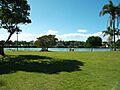
Banner Park, east side of Brunswick Terrace, showing Simpson's Creek, May 2014
-
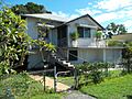
A private residence in Tweed Street, May 2014
-
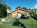
Brunswick Heads RSL, May 2014
-
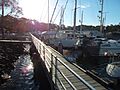
Jetty, Brunswick Heads Boat Harbour, May 2014
-
Brunswick River facing east (toward the sea). A holiday camp can be seen on the right, May 2014
-
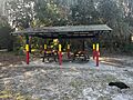
A picnic area in Brunswick Heads featuring Bundjalung words and their translations, September 2024
-
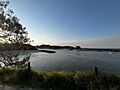
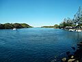
A view of Brunswick Heads, September 2024
-
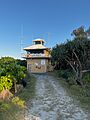
Marine Rescue Brunswick, September 2024


