
Mullumbimby facts for kids
Quick facts for kids MullumbimbyNew South Wales |
|
|---|---|

Burringbar Street—Mullumbimby's main street
|
|

Mullumbimby
Location in New South Wales
|
|
| Population | 3,589 (2021 census) |
| Postcode(s) | 2482 |
| Elevation | 6 m (20 ft) |
| Location |
|
| LGA(s) | Byron Shire |
| State electorate(s) | Ballina |
| Federal Division(s) | Richmond |

Mullumbimby, often called Mullum, is a town in the Byron Shire area of New South Wales, Australia. It's known as "The Biggest Little Town in Australia". The town sits at the base of Mount Chincogan in the Brunswick Valley, about 9 kilometres (5.5 miles) from the coast.
In 2021, Mullumbimby and its nearby areas had about 3,589 people living there. The Bundjalung people were the first people to live here. They are the traditional owners of this land.
Contents
Discovering Mullumbimby's Past
The first European to explore this area was Captain Henry Rous in 1828. Later, the land was used for dairy farming and growing fruits. In 2022, Mullumbimby was affected by floods.
How Mullumbimby Got Its Name

In the 1850s, European settlers set up a camp where two parts of the Brunswick River met. This camp grew into the village and then the town of Mullumbimby.
The town was first a hub for the timber industry. Many red cedar trees were cut down from the surrounding "Big Scrub" forest. Mullumbimby was a good spot for timber hunters because the Brunswick River is tidal here. Logs could float down the river to Brunswick Heads.
The town's name, "Mullumbimby," means "small round hill" in the Aboriginal Bandjalung-Yugambeh dialect. Some think it refers to Mount Chincogan, but others believe it's about a smaller, rounder hill nearby. These hills were surrounded by natural grass flats, which were important hunting grounds for the local Bundjalung people. Early European timber hunters also used these flats to graze their bullock teams.
Mullumbimby's Unique Culture


Mullumbimby was its own town council from 1908 until 1980. Then, it joined with the Byron Shire. The Byron Shire Council offices moved to Mullumbimby in 1996.
The Byron Shire, including Mullumbimby and Byron Bay, became a center for alternative lifestyles in the 1970s and 1980s. This continues today. For example, a male choir called Dustyesky performs Russian folk songs here.
After the valuable timber was mostly gone, Mullumbimby became a farming town. Farmers grew beef, dairy, bananas, and sugar cane. Now, there are many smaller farms, leading to a wider variety of local products. A weekly farmers' market sells these local goods.
Mullumbimby was one of the first country towns in New South Wales to get electricity. This happened in 1925, thanks to a hydroelectric power scheme. This scheme used water from a weir in nearby Wilsons Creek. The site is now considered important for its history.
Important Heritage Sites
Mullumbimby has several places listed for their historical importance. One well-known site is the:
- Wilsons Creek Road: Mullumbimby Hydro-electric Power Station Complex
Mullumbimby's Population Over Time
| Historical population | ||
|---|---|---|
| Year | Pop. | ±% |
| 1921 | 1,329 | — |
| 1933 | 1,362 | +2.5% |
| 1947 | 1,609 | +18.1% |
| 1954 | 2,017 | +25.4% |
| 1961 | 1,966 | −2.5% |
| 1966 | 1,981 | +0.8% |
| 1971 | 1,891 | −4.5% |
| 1976 | 2,028 | +7.2% |
| 1981 | 2,234 | +10.2% |
| 1986 | 2,453 | +9.8% |
| 1991 | 2,612 | +6.5% |
| 1996 | 2,870 | +9.9% |
| 2001 | 2,989 | +4.1% |
| 2006 | 3,129 | +4.7% |
| 2011 | 3,164 | +1.1% |
| 2016 | 3,248 | +2.7% |
| 2021 | 3,589 | +10.5% |
| Source: Australian Bureau of Statistics data. | ||
In the 2021 Census, 3,589 people lived in Mullumbimby. Most people (70.4%) were born in Australia. Other common birthplaces included England (5.9%), New Zealand (1.9%), and Germany (1.6%). About 81.0% of people spoke only English at home.
Many people (59.2%) said they had no religion. The most common backgrounds were English, Australian, Irish, Scottish, and German. Aboriginal and/or Torres Strait Islander people made up 1.8% of the population in 2016.
Mullumbimby's Geography

Mullumbimby is about 4 kilometres (2.5 miles) west of the Pacific Highway. The Brunswick River begins in Mullumbimby. It forms where Main Arm and Mullumbimby creeks meet.
The town is close to places like Ocean Shores, Brunswick Heads, and Wilsons Creek. The area around Mullumbimby includes Goonengerry, Main Arm, and Palmwoods.
Mount Chincogan, a key feature of Mullumbimby, was once a minor lava plug. It was part of the ancient Tweed shield volcano, with Mount Warning being the main plug.
Ancient Stone Arrangements
There are reports of stone arrangements on the Slater mounds, west of Saddle Ridge. Some people believe these arrangements are very old, possibly from the Stone Age, even older than Stonehenge. In the late 1930s, a headmaster from Brunswick Heads told Mr. Frederic Slater about them. Slater thought the carvings on the stones might be the earliest form of human language. However, others disagree and consider this idea unproven. Sadly, the stones described in the 1930s have now disappeared.
Mullumbimby's Alternative Views
Mullumbimby is known for its community of people who embrace alternative lifestyles and different ways of thinking. Many locals are interested in natural health and question mainstream ideas. This has led to discussions about topics like vaccination rates and new technologies.
Sports and Fun
The Mullumbimby Giants is the local rugby league club. They play in the Northern Rivers Regional Rugby League competition.
Famous People From Mullumbimby
Many notable people have connections to Mullumbimby:
- Vic Armbruster, an Australian rugby league player.
- Iggy Azalea, a famous rapper and songwriter. Her stage name was partly inspired by Azalea Street in Mullumbimby, where she grew up.
- Bob Bellear, Australia's first Aboriginal judge.
- Renee Bargh, an Australian TV presenter.
- Petria Thomas, an Olympic gold medalist in swimming.
- Joel Turner, a beatboxer and musician.
- Edwin Wilson, an author who wrote about Mullumbimby.
- Mandy Nolan, a comedian and writer.
Images for kids
-
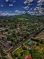
Aerial view of Mullumbimby in autumn 2018
-
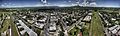
Another aerial view of Mullumbimby in autumn 2018

