
Wilsons River (New South Wales) facts for kids
Quick facts for kids Wilsons River |
|
|---|---|

Wilsons River flowing through Lismore, 2006.
|
|

Location of the Wilsons River mouth in New South Wales
|
|
| Other name(s) | Wilsons Creek, North Arm Richmond River |
| Country | Australia |
| State | New South Wales |
| Region | NSW North Coast (IBRA), Northern Rivers |
| LGAs | Byron, Richmond Valley, Lismore |
| City | Lismore |
| Physical characteristics | |
| Main source | Nightcap National Park near Jerusalem Mountain 362 m (1,188 ft) |
| River mouth | Richmond River near Coraki 3.6 m (12 ft) 28°59′2″S 153°17′19″E / 28.98389°S 153.28861°E |
| Length | 131 km (81 mi) |
| Basin features | |
| River system | Richmond River catchment |
| Tributaries |
|
| Bridges |
|
| National park | Nightcap National Park |
The Wilsons River is a river in the Northern Rivers area of New South Wales, Australia. It flows all year round and is part of the larger Richmond River system.
Contents
Journey of the Wilsons River
The Wilsons River starts high up on the eastern side of Jerusalem Mountain. This mountain is found inside the Nightcap National Park. From there, the river flows for about 131 kilometres (81 mi). It travels generally southeast, then west southwest, and finally south.
Along its journey, five smaller streams join the Wilsons River. It eventually meets the Richmond River near a town called Coraki. The river drops about 359 metres (1,178 ft) from its start to where it joins the Richmond River.
The River and Lismore
The Wilsons River flows right through the big city of Lismore. Because of this, the city often experiences floods when the river gets too full.
Traditional Owners and Naming
The original people of the land around the Wilsons River are the Bundjalung clan. They are Aboriginal people who lived as hunter-gatherers.
The river was first called Wilsons Creek. It was named after William Wilson, who was the first European settler in Lismore around 1844-1845. In 1976, the name was officially changed to Wilsons River.
River Health and Wildlife

The Wilsons River system is affected by farming and city development. This means things like dirt, extra nutrients, rubbish, and other harmful substances can get into the water.
Protecting the River
Groups like Landcare and government bodies are working to make parts of the river healthy again. They are trying to clean up the water and improve the river environment.
Animals and Plants
Sadly, a fish called the Eastern freshwater cod used to live in the Wilsons River. However, it has not been seen for many years and is now thought to be extinct in this area.
In the lower parts of the Wilsons River, you might find the European Carp. This is a fish that is not native to Australia and can cause problems for local fish. There are also harmful water weeds like Alligator Weed and Parrots Feather.
Understanding Floods

The Wilsons River floods often. Sometimes, it can even flood the city of Lismore. This is why many homes in Lismore are built on high stilts, a style known as hiset. Lismore also has large levee systems. These are walls built to protect the city from most floods.
Why Floods Happen
Several things cause the river to flood so often:
- Heavy Rain: The areas where the river starts get a lot of rain. One rain gauge in the area records the most rain in New South Wales.
- Unusual Flow: The river flows away from the ocean for a long distance after Lismore. Then it flows south before joining the Richmond River. This river then flows northeast to the Tasman Sea.
- Low-lying Land: Much of the land around the river is close to sea level. This makes the water flow slower, causing it to build up.
The Floodplain
The area around the Wilsons River that gets flooded is very large. This floodplain starts near where Byron Creek joins the river and goes all the way to Coraki. In some places, it can be several kilometres wide.
The floodplain soil is usually very rich and good for growing things. However, because it floods so often, it is mostly used for grazing cattle and dairy farms.
The 2017 Flood
On March 30, 2017, a huge amount of rain fell, between 500 to 740 millimetres (20 to 29 in). This was caused by the leftover effects of Cyclone Debbie. The Wilsons River flooded Lismore the next day, reaching a peak of 11.6 metres (38 ft). This was higher than the 10.6 metres (35 ft)-high levee that protects the city.
River Trade in the Past
Before Europeans arrived, the local Indigenous people likely used canoes to travel and trade along the Wilsons River.
After Europeans settled, many towns like Lismore, Wyrallah, Bexhill, and Coraki grew up along the river. This was because river transport was the best way to move goods.
Early European Use
In 1828, Henry John Rous explored and mapped the Wilsons River, which was then called the North Arm of the Richmond River. This part of the river was the furthest ships could travel. It was important for shipping out red cedar, a valuable timber cut from the huge Big Scrub rainforest that once covered the area.
In the early 1900s, ships carried goods like bacon, corn, eggs, butter, and cut logs. Some of the ships were called the Cavanba, Tomki, City of Grafton, and Wyoming. The last company to transport goods by ship on the Richmond and Wilsons rivers stopped in the 1960s.
Streams Joining the River
The Wilsons River has several smaller streams, or tributaries, that flow into it. These include Leycester Creek, Coopers Creek, Pearces Creek, and Byron Creek. Leycester Creek is the largest tributary that joins the river closer to its mouth.
Leycester Creek
Leycester Creek joins the Wilsons River at Lismore. If both creeks are flooding at the same time, it can make floods in Lismore even worse. This is partly because of how the creeks meet, which can push water towards the main Lismore Levee.
Coopers Creek
Coopers Creek joins the Wilsons River near the village of Bexhill. This area is home to the Boat Harbour Nature Reserve, which has one of the largest remaining parts of the Big Scrub rainforest. This is also the furthest point upstream where the river is affected by ocean tides.
Byron Creek
Byron Creek starts only about 2 kilometres (1.2 mi) from the Tasman Sea. However, like much of the Wilsons River system, it flows inland for a long way. This is unusual for a river so close to the coast.
Drinking Water Supply
The Wilsons River provides drinking water for many people in the region.
Mullumbimby's Water
The Byron Shire Council gets water from the Lavertys Gap Weir on the river. This water is cleaned at a nearby treatment plant and then supplied to the town of Mullumbimby.
Regional Water Supply
Rous Water also takes water from a freshwater tidal pool upstream of Lismore. This water helps to top up the supply from Rocky Creek Dam. This combined water supply goes to large parts of the Byron Shire, Ballina Shire, Richmond Valley Council, and City of Lismore areas. The water is pumped to the Nightcap Water Treatment Plant near Rocky Creek Dam, cleaned, and then sent by gravity to these areas.
Water for Farms
Farmers in the region also use water from the Wilsons River. They use it to water their crops, mainly pastures for animals, and to provide water for their livestock and some homes. The water in the Coopers Creek tributary has been used a lot in the past. Because of this, the NSW Government has created a plan to share the water fairly.
Images for kids
-
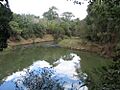
The Wilsons River at Boatharbour Reserve
-
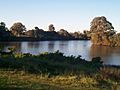
Junction of the Wilson and Richmond rivers at Coraki, 2007
