
Black Lake Denesuline First Nation facts for kids
Band symbol
|
|
-001.jpg)
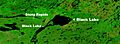
Satellite image of Black Lake
|
|
| People | Chipewyan |
|---|---|
| Treaty | Treaty 8 |
| Headquarters | Black Lake |
| Province | Saskatchewan |
| Land | |
| Reserve(s) | |
| Land area | 322.197 km2 |
| Population (2019) | |
| On reserve | 1638 |
| Off reserve | 617 |
| Total population | 2255 |
| Government | |
| Chief | Coreen Sayazie |
| Tribal Council | |
| Prince Albert Grand Council | |
| Website | |
| blacklakefirstnation.ca | |
Black Lake (which means Tazen Tuwé in the Denesuline language) is a First Nations community in northern Saskatchewan, Canada. It is home to the Denesuline people, who are part of the larger Chipewyan group. The community is located by the northwest shore of Black Lake. Here, the Fond du Lac River starts its journey towards Lake Athabasca.
Black Lake is the main place where the Black Lake Denesuline Nation manages its land. This land covers a very large area, more than 32,000 hectares (about 79,000 acres). In the past, the Black Lake community was sometimes called "Stony Rapids". However, Stony Rapids is now a separate community about 20 kilometers (12 miles) away.
Contents
What is the Black Lake Denesuline Nation?
The Black Lake Denesuline Nation is a band government. A band government is like a local government for a First Nations community. It helps manage the community's land, services, and people. The Black Lake Denesuline Nation has land in three main areas, which are called Chicken 224, Chicken 225, and Chicken 226.
Where are the Black Lake Lands?
- Chicken 224 is the largest area, covering about 25,819 hectares (63,800 acres). This is where the main village of Black Lake is located. It stretches from Black Lake up to the edge of the Stony Rapids community.
- Chicken 225 is a smaller area, about 2,183 hectares (5,395 acres). It is located on the north side of Stony Lake, which is also on the Fond du Lac River.
- Chicken 226 covers about 4,216 hectares (10,420 acres). You can find this land on the eastern side of Black Lake.
In September 2013, the Black Lake First Nation had 2,044 registered members. This means 2,044 people were officially part of the nation. Most of them, 1,592 members, lived on their reserve lands. The other 452 members lived in different places off the reserve. The Black Lake First Nation is also a member of the Prince Albert Grand Council, which is a larger group of First Nations working together.
How Many People Live in Black Lake?
In 2011, a census (a count of people) showed that 1,040 people living in Black Lake spoke Dene as their first language. Almost everyone in the community, except for 5 people, also spoke English.
| Canada census – Black Lake Denesuline First Nation community profile | |||
|---|---|---|---|
| 2011 | 2006 | ||
| Population: | 1,070 (-3.5% from 2006) | 1,109 (+5.2% from 2001) | |
| Land area: | 234.44 km2 (90.52 sq mi) | 234.44 km2 (90.52 sq mi) | |
| Population density: | 4.6/km2 (12/sq mi) | 4.7/km2 (12/sq mi) | |
| Median age: | 22.5 (M: 22.4, F: 22.8) | 20.9 (M: 20.8, F: 21.1) | |
| Total private dwellings: | 234 | 227 | |
| Median household income: | |||
| References: 2011 2006 earlier | |||
How Do People Get Around in Black Lake?
Roads and Airports
Black Lake can be reached by road all year round. This became possible after Highway 905 was completed. Before that, the road was only open during certain seasons. You can also get to Black Lake by road from the nearby community of Stony Rapids. Stony Rapids has an airport, so people can fly there and then drive to Black Lake.
The community of Black Lake itself has an airport for floatplanes, called Black Lake Water Aerodrome. There is also the Stony Rapids Airport nearby, which serves the region.
What About Education in Black Lake?
The Father Porte Memorial School in Black Lake offers classes from kindergarten all the way up to grade 12. This school helps educate the young people of the community. It has about 460 students.
Images for kids
-
Satellite image of Black Lake
