Stony Rapids facts for kids
Quick facts for kids
Stony Rapids
Deschaghe
|
|
|---|---|
|
Northern hamlet
|
|
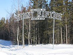
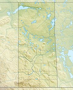
 Stony Rapids Sign  NASA map of Stony Rapids |
|
| Country | Canada |
| Province | Saskatchewan |
| Post office established | 1937 |
| Area | |
| • Total | 3.96 km2 (1.53 sq mi) |
| Population
(2011)
|
|
| • Total | 243 |
| • Density | 61.3/km2 (159/sq mi) |
| Time zone | UTC−6 (Central Standard Time) |
| • Summer (DST) | UTC−5 |
| Postal code |
S0J 2R0
|
Stony Rapids is a small community in Northern Saskatchewan, Canada. Its name in the local Dene is Deschaghe, which means "settlement on the other side of the Rapids."
This community is located about 82 kilometers (51 miles) south of the Northwest Territories border. It sits right on the Fond du Lac River. This river is important because it connects Stony Rapids to other places like Fond-du-Lac, Uranium City, and Camsell Portage.
Contents
How Many People Live in Stony Rapids?
In 2021, a count of the population showed that 219 people lived in Stony Rapids. These people lived in 75 homes. This number was a bit lower than in 2016, when 262 people lived there. The community covers an area of about 4.24 square kilometers (1.64 square miles).
Getting Around Stony Rapids
One main road, Saskatchewan Highway 905, connects Stony Rapids to Highway 102. This highway is about 469 kilometers (291 miles) long and is not paved. A part of it, about 185 kilometers (115 miles) long, turns into a special winter road during the cold months. This section is between Points North Landing and Black Lake.
There is also a winter ice road that connects Fond-du-Lac and Uranium City. An all-season road links Stony Rapids to the community of Black Lake, which is about 20 kilometers (12 miles) southeast.
Like many communities in the north, Stony Rapids relies on its Stony Rapids Airport and Stony Rapids Water Aerodrome for important travel and supplies.
Health Care in Stony Rapids
The Athabasca Health Facility was finished in 2003. It cost $12.7 million to build. This facility provides health care services for the entire Athabasca region. The hospital is located on land belonging to the Black Lake Dene Nation, right next to Stony Rapids. It is part of the Athabasca Health Authority.
Weather in Stony Rapids
Stony Rapids has a subarctic climate. This means it has very long and cold winters. The summers are short, but they can be mild to warm.
Winters are snowy, with snow often reaching about 0.6 meters (2 feet) deep. Sometimes, it can get as deep as 1.09 meters (3.6 feet)! The snow usually melts by mid-May. It's very rare for the temperature to go above 0 degrees Celsius (32 degrees Fahrenheit) in winter. Snow falls steadily from October to April.
Summers are mild to warm and often have light rain. Temperatures can reach 30 degrees Celsius (86 degrees Fahrenheit) about three to four days each summer. The time without frost, when plants can grow, is usually 81 days long, from June 9 to August 30. However, temperatures below 0 degrees Celsius have happened a few times even in July.
The hottest temperature ever recorded in Stony Rapids was 39.8 degrees Celsius (103.6 degrees Fahrenheit) on June 30, 2021. The coldest temperature ever recorded was -50.6 degrees Celsius (-59.1 degrees Fahrenheit) on January 26, 1966, and January 13, 1972.
| Climate data for Stony Rapids Airport, 1981−2010 normals, extremes 1960−present | |||||||||||||
|---|---|---|---|---|---|---|---|---|---|---|---|---|---|
| Month | Jan | Feb | Mar | Apr | May | Jun | Jul | Aug | Sep | Oct | Nov | Dec | Year |
| Record high °C (°F) | 5.4 (41.7) |
8.0 (46.4) |
17.2 (63.0) |
22.2 (72.0) |
33.1 (91.6) |
39.8 (103.6) |
38.5 (101.3) |
35.7 (96.3) |
30.6 (87.1) |
23.5 (74.3) |
10.0 (50.0) |
3.9 (39.0) |
39.8 (103.6) |
| Mean daily maximum °C (°F) | −19.5 (−3.1) |
−15.1 (4.8) |
−6.6 (20.1) |
3.8 (38.8) |
12.1 (53.8) |
19.9 (67.8) |
22.7 (72.9) |
20.3 (68.5) |
12.7 (54.9) |
3.3 (37.9) |
−8.2 (17.2) |
−16.4 (2.5) |
2.4 (36.3) |
| Daily mean °C (°F) | −24.8 (−12.6) |
−21.2 (−6.2) |
−14.1 (6.6) |
−3.0 (26.6) |
5.6 (42.1) |
12.9 (55.2) |
15.9 (60.6) |
14.0 (57.2) |
7.5 (45.5) |
−0.5 (31.1) |
−12.4 (9.7) |
−21.4 (−6.5) |
−3.5 (25.7) |
| Mean daily minimum °C (°F) | −30.0 (−22.0) |
−27.4 (−17.3) |
−21.6 (−6.9) |
−9.9 (14.2) |
−1.0 (30.2) |
5.8 (42.4) |
9.1 (48.4) |
7.7 (45.9) |
2.4 (36.3) |
−4.3 (24.3) |
−16.7 (1.9) |
−26.2 (−15.2) |
−9.3 (15.3) |
| Record low °C (°F) | −50.6 (−59.1) |
−48.9 (−56.0) |
−46.1 (−51.0) |
−38.9 (−38.0) |
−18.3 (−0.9) |
−5.0 (23.0) |
−1.1 (30.0) |
−2.8 (27.0) |
−11.1 (12.0) |
−24.4 (−11.9) |
−45.6 (−50.1) |
−48.2 (−54.8) |
−50.6 (−59.1) |
| Average precipitation mm (inches) | 19.3 (0.76) |
15.3 (0.60) |
20.6 (0.81) |
18.9 (0.74) |
32.0 (1.26) |
45.6 (1.80) |
62.4 (2.46) |
70.3 (2.77) |
59.3 (2.33) |
34.6 (1.36) |
30.1 (1.19) |
17.8 (0.70) |
426.2 (16.78) |
| Average rainfall mm (inches) | 0.1 (0.00) |
0.0 (0.0) |
0.4 (0.02) |
5.2 (0.20) |
22.5 (0.89) |
45.5 (1.79) |
62.4 (2.46) |
70.3 (2.77) |
57.2 (2.25) |
16.7 (0.66) |
1.7 (0.07) |
0.3 (0.01) |
282.3 (11.12) |
| Average snowfall cm (inches) | 35.3 (13.9) |
27.5 (10.8) |
30.9 (12.2) |
20.2 (8.0) |
12.2 (4.8) |
0.1 (0.0) |
0.0 (0.0) |
0.0 (0.0) |
2.8 (1.1) |
25.0 (9.8) |
48.2 (19.0) |
32.2 (12.7) |
234.4 (92.3) |
| Average precipitation days (≥ 0.2 mm) | 12.7 | 10.6 | 10.1 | 7.5 | 10.2 | 11.1 | 13.7 | 14.6 | 14.4 | 14.8 | 14.6 | 12.0 | 146.3 |
| Average rainy days (≥ 0.2 mm) | 0.17 | 0.04 | 0.64 | 2.6 | 8.3 | 11.1 | 13.7 | 14.6 | 13.9 | 7.5 | 1.0 | 0.63 | 74.2 |
| Average snowy days (≥ 0.2 cm) | 15.8 | 13.7 | 12.0 | 6.4 | 3.6 | 0.1 | 0.0 | 0.04 | 1.6 | 10.4 | 17.8 | 16.3 | 97.7 |
| Source: Environment Canada | |||||||||||||
See also
- List of communities in Saskatchewan
 | Emma Amos |
 | Edward Mitchell Bannister |
 | Larry D. Alexander |
 | Ernie Barnes |


