Fond du Lac Denesuline First Nation facts for kids
 |
|
| People | Denesųłiné |
|---|---|
| Treaty | Treaty 8 |
| Headquarters | Fond du Lac |
| Province | Saskatchewan |
| Land | |
| Reserve(s) | |
| Land area | 368.121 km2 |
| Population (2019) | |
| On reserve | 1133 |
| Off reserve | 995 |
| Total population | 2128 |
| Tribal Council | |
| Prince Albert Grand Council | |
| Website | |
| fonddulac.ca | |
|
Fond du Lac
Gánį Kóé
|
|
|---|---|

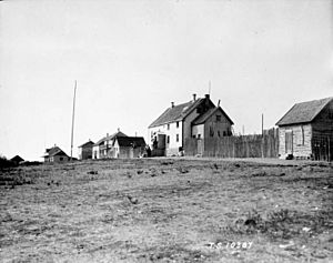
Fond du Lac main street 1926
|
|
| Nickname(s):
fdl
|
|
| Country | Canada |
| Province | Saskatchewan |
| Area | |
| • Total | 138.26 km2 (53.38 sq mi) |
| Population
(2011)
|
|
| • Total | 874 |
| • Density | 6.3/km2 (16/sq mi) |
| Time zone | UTC−6 (Central Standard Time) |
| • Summer (DST) | UTC−5 |
| Postal code |
S0J 0W0
|
The Fond du Lac Dene Nation (which is called Gánį Kóé in their own language) is a First Nation group. They live in the boreal forest area of northern Saskatchewan, Canada. Their main community, also called Fond-du-Lac, is on the east side of Lake Athabasca. It's a remote place, meaning you usually have to fly in to get there. In 2011, about 874 people lived there, mostly from the Dene and Métis groups. Many residents, about 705, spoke Dene as their first language.
The name "Fond du Lac" comes from French. It means "far end of the lake" or "bottom of the lake."
Contents
History of Fond du Lac Dene Nation

The community of Fond-du-Lac started over 150 years ago. It was founded by Denesuline First Nations people. They came here to hunt for furs, fish, and trap animals. Not much has changed since then. Many people living in the community today can trace their family roots back to the early 1800s. Living off the land is still a very important way of life in Fond-du-Lac.
Many residents are descendants of a group called the Maurice's Band. This band signed an agreement called Treaty 8 in 1899. Later, in 1949, the Maurice's Band split into two new groups: the Fond-du-Lac Band and the Black Lake Band.
Fond du Lac Reserves
The Fond du Lac Dene Nation has six special territories, called reserves, located around the eastern part of Lake Athabasca.
- Fond du Lac 227 is a large area of about 15,520 hectares (38,350 acres). It's on the north shore of Lake Athabasca and includes the village of Fond du Lac.
- Fond du Lac 228 is about 1,082.5 hectares (2,675 acres). It's located across the lake from the main village.
- Fond du Lac 229 is about 7,821.1 hectares (19,326 acres). This reserve is west of the village on the north shore of the lake. No one lived there in 2011.
- Fond du Lac 231 is about 2,023.5 hectares (5,000 acres). It borders the Athabasca Sand Dunes Provincial Park on the McFarlane River. No one lived there in 2011.
- Fond du Lac 232 is also about 2,023.5 hectares (5,000 acres). It's on the Otherside River, east of Fond du Lac 231. No one lived there in 2011.
- Fond du Lac 233 is about 8,341.5 hectares (20,612 acres). It's on the south side of the lake and surrounds Fond du Lac 228. No one lived there in 2011.
In September 2013, the Fond du Lac First Nation had 1,895 registered members. About 1,066 members lived on their reserves, and 829 members lived in other places. The Fond du Lac First Nation is part of the Prince Albert Grand Council.
Population of Fond du Lac
| Canada census – Fond du Lac 227 community profile | |||
|---|---|---|---|
| 2011 | 2006 | ||
| Population: | 874 (+9.1% from 2006) | 801 (+17.4% from 2001) | |
| Land area: | 138.26 km2 (53.38 sq mi) | 138.26 km2 (53.38 sq mi) | |
| Population density: | 6.3/km2 (16/sq mi) | 5.8/km2 (15/sq mi) | |
| Median age: | 22.9 (M: 22.3, F: 23.4) | 19.9 (M: 19.8, F: 20.2) | |
| Total private dwellings: | 229 | 182 | |
| Median household income: | |||
| References: 2011 2006 earlier | |||
Economy and Jobs
Today, many people in Fond du Lac work in the mining and other resource industries. Some still follow the old ways of life, like fishing, hunting, and trapping. They also offer guide services to people who visit the many fishing camps in the area.
Getting Around Fond du Lac
There are only a few roads within the community itself. There are no roads that connect Fond du Lac to other towns all year round. You can usually only get there by flying into the Fond-du-Lac Airport, by boat on the water, or by snowmobile in winter. People in the community often use large trucks and ATVs (also known as four-wheelers) to get around.
In the winter, a special ice road forms. This road connects Fond du Lac to Uranium City and Stony Rapids. Stony Rapids then has another ice road that links it to the rest of the province. The community depends a lot on airplanes and barges to bring in supplies and services. Sometimes, in winter, trucks will use the ice road to bring in supplies.
Climate in Fond du Lac
Fond-du-Lac has a typical northern Saskatchewan subarctic climate. This means it has very long and cold winters. The summers are short, but they can be mild to warm.
| Climate data for Fond-du-Lac | |||||||||||||
|---|---|---|---|---|---|---|---|---|---|---|---|---|---|
| Month | Jan | Feb | Mar | Apr | May | Jun | Jul | Aug | Sep | Oct | Nov | Dec | Year |
| Mean daily maximum °C (°F) | −24 (−11) |
−20 (−4) |
−12 (10) |
0 (32) |
9 (48) |
17 (62) |
20 (68) |
18 (64) |
11 (51) |
2 (35) |
−9 (15) |
−17 (2) |
0 (31) |
| Daily mean °C (°F) | −28 (−18) |
−25 (−13) |
−18 (0) |
−6 (21) |
4 (39) |
11 (51) |
15 (59) |
13 (55) |
7 (44) |
0 (32) |
−12 (10) |
−23 (−9) |
−5 (23) |
| Mean daily minimum °C (°F) | −32 (−25) |
−30 (−22) |
−24 (−11) |
−12 (10) |
−1 (30) |
5 (41) |
10 (50) |
8 (46) |
2 (35) |
−3 (26) |
−15 (5) |
−26 (−14) |
−10 (14) |
| Average precipitation mm (inches) | 20 (0.8) |
15 (0.6) |
18 (0.7) |
18 (0.7) |
20 (0.8) |
36 (1.4) |
51 (2.0) |
48 (1.9) |
36 (1.4) |
33 (1.3) |
28 (1.1) |
20 (0.8) |
343 (13.5) |
| Source: http://www.weatherbase.com/weather/weather.php3?s=710762 | |||||||||||||
 | Bessie Coleman |
 | Spann Watson |
 | Jill E. Brown |
 | Sherman W. White |


