
Athabasca Sand Dunes Provincial Park facts for kids
Quick facts for kids Athabasca Sand Dunes Provincial Park |
|
|---|---|
|
IUCN Category Ib (Wilderness Area)
|
|

Flyover of the sand dunes
|
|

Athabasca Sand Dunes Provincial Park
Location in Canada
|
|
| Location | |
| Nearest city | Uranium City |
| Area | 1,925 square kilometres (743 sq mi) |
| Established | October 1988 |
| Governing body | Saskatchewan Parks |
The Athabasca Sand Dunes Provincial Park is a very special place in northern Saskatchewan, Canada. It was created to protect the amazing Athabasca sand dunes. These dunes are part of a unique boreal shield ecosystem.
What makes them so special? They are one of the most northerly active sand dune areas on Earth! Imagine huge sand dunes far up north, where you might expect forests or tundra.
People first thought about protecting this area in 1969. It officially became the Athabasca Sand Dunes Provincial Wilderness Park on August 24, 1992.
The park stretches for 100 kilometres (about 62 miles) along the southern edge of Lake Athabasca. It sits within the Athabasca Basin, which is part of the ancient Canadian Shield. The sand dunes themselves are quite large, ranging from 400 to 1,500 metres (about 1,300 to 4,900 feet) long. Some dunes can reach a height of about 30 metres (nearly 100 feet)!
Getting to the park is an adventure in itself. You can only reach it by float plane or by boat. Two rivers flow through the park: the William River in the west, which forms a large river delta, and the McFarlane River in the east. The park surrounds a First Nations reserve called Fond du Lac 231. The village of Fond du Lac is about 44 kilometres (27 miles) by air from the park's eastern border.
Contents
How the Dunes Were Formed
Ancient Ice and Water
The Athabasca Sand Dunes are about 8,000 years old. They formed near the end of the last glacial period, which was a time when much of the Earth was covered in ice. As the giant glaciers melted, they washed huge amounts of sand, silt, and other sediments into Lake Athabasca. Back then, the lake was much bigger and deeper than it is today.
Sand Revealed by Receding Water
Over time, the water level of Lake Athabasca dropped to its current depth. This revealed the massive sand deposits that the glaciers had left behind. These sand deposits then became the dunes we see today.
Shifting Sands and Unique Features
The sand dunes are always changing. Strong winds constantly push and reshape them. These winds can even move the edges of the dunes into the surrounding forest. There's also evidence that fires have played a role in how the winds shape the dunes.
Interestingly, the dunes closer to the lake are more active and shift a lot. However, the dunes further south are quite stable compared to other areas in the region. You can also find other cool geological features here, like eskers (long ridges of sand and gravel left by glaciers) and beach ridges. Some parts of the William River even flow through braided channels in the sand, which look like many small streams weaving together.
The dunes are mostly parabolic in shape, which means they look like a U or V. The sand almost completely covers the bedrock underneath, which is usually about 20 metres (65 feet) below the surface. The entire sandy area acts like a giant underground water storage, called an aquifer. This underground water greatly affects the plant life and how the dunes develop.
Rare Plants of the Dunes
This special area is home to some very rare plants. These plants are called endemic species, meaning they are found here and nowhere else in the world! It's like they have their own secret garden.
Some of the unique plants you might find include:
- Felt-leaved willow (Salix silicicola)
- Mackenzie hairgrass (Deschampsia mackenzieana)
- Tyrrell's willow (Salix planifolia tyrrellii)
- Floccose tansy (Tanacetum huronense var. floccosum)
These plants have adapted to live in the sandy, windy conditions of the dunes, making them truly special.
Images for kids
-
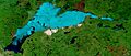
Lake Athabasca (data date June 9, 2002): the ice is light blue, dark blue is open water and the sand dunes located within the park on the south shore are white.

Maps
- Mouth of the William River 59°8′48.16″N 109°18′28.02″W / 59.1467111°N 109.3077833°W
- Mouth of the McFarlane River 59°12′38.21″N 107°57′44.75″W / 59.2106139°N 107.9624306°W
