Blackhand Gorge State Nature Preserve facts for kids
Quick facts for kids Blackhand Gorge State Nature Preserve |
|
|---|---|
 |
|
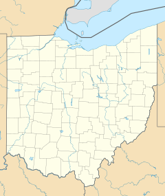
| Location | Licking County, Ohio |
| Nearest city | Newark, Ohio |
| Area | 957 acres (387 ha) |
| Established | 1975 |
| Governing body | Ohio Department of Natural Resources |
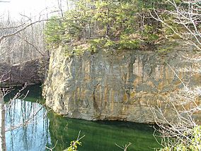
The Blackhand Gorge State Nature Preserve is a special place in Licking County, Ohio, United States. It's a 4 miles (6.4 km)-long area with tall sandstone cliffs. The Licking River flows right through it.
This preserve is about 12 miles (19 km) east of Newark, Ohio, near a small town called Toboso, Ohio. In 1975, 957 acres (387 ha) of the gorge became an Ohio Nature Preserve. It's like a living museum of transportation history! Over the years, canal boats, steam railroads, electric trains (called electric interurbans), and even automobiles have traveled through here.
The gorge gets its name from a black hand symbol that was once carved into the cliff. Early settlers saw this petroglyph (rock carving). The rock itself, called Black Hand Sandstone, is very strong. It also forms the backbone of the famous Hocking Hills region.
Contents
A Journey Through Time
People have lived in the Blackhand Gorge area for a very long time. From about 13,000 BC to 400 AD, early Native American groups, like the Hopewell Indians, visited this gorge. Later, in the early 1800s, settlers from Europe used it as a path through the hilly parts of eastern Ohio.
The Mystery of the Black Hand
The Blackhand Gorge is named after a prehistoric petroglyph. This was a carving of a black hand with fingers spread out and part of a wrist. Some say one long finger pointed towards a nearby Indian mound. People believe the symbol meant that all tribes passing through the gorge had to do so peacefully. They were on their way to important flint pits a few miles south.
Sadly, the original Black Hand carving was destroyed in 1828. This happened during the building of the Ohio and Erie Canal. Other rock carvings survived until 1890. Many of these were recorded by Dr. James Salisbury and his brother Charles. They made tracings and notes, which are now kept by the American Antiquarian Society. Blasting for the electric interurban railway in 1890 removed the last of these ancient carvings.
The Legend of the Black Hand Gorge
Many stories and legends come from the Native American Indians. One beautiful legend is about Ahyoma, the daughter of Chief Pawcongah, and the "Black Hand."
Indians needed sharp tips for their arrows to hunt. They used a natural resource called flint, which was found on a ridge between Zanesville and Newark. This place was known as Flint Ridge.
The legends say that the "Great Father" called all the tribes together. He told them that when they were at the flint pits, no fighting or bloodshed was allowed. Flint Ridge was to be sacred ground. For many years, the tribes followed this rule. They shared the valuable flint peacefully.
Chief Pawcongah had a beautiful daughter named Ahyoma. Many brave warriors wanted to marry her. Her father said that the warrior who brought the most scalps (trophies from battle) would win her hand.
Two brave warriors returned. The first was Waconsta, who laid many trophies at the chief's feet. The second was Lahkopis, whom Ahyoma truly loved. Waconsta had more scalps, so he was chosen to marry Ahyoma the next day.
That night, Ahyoma decided to run away with Lahkopis. They hoped to reach the sacred ground at Flint Ridge, where they would be safe. No blood was allowed to be spilled there.
Waconsta chased them, forgetting the rule about the sacred ground. As the two lovers stood on a high ridge, Waconsta raised his tomahawk to strike. Lahkopis quickly raised his own tomahawk to defend Ahyoma. With one swift move, he cut off Waconsta's hand.
Ahyoma and Lahkopis fell into the Licking River during the struggle. Waconsta's hand fell with them and stuck to the side of the cliff. The hand turned black and grew larger. It stayed there as a warning to all tribes: never again should blood be spilled at the arrow pits of Flint Ridge.
When the canal was built in 1828, the part of the rock with the hand carving was blasted away. This made room for the towpath, a path for horses to pull canal boats. Today, the area is still known as the "Black Hand Gorge."
The Ohio and Erie Canal (1825)
On July 4, 1825, important leaders started digging for the Ohio and Erie Canal. This happened near Newark, Ohio. At the time, Ohio farmers couldn't sell their crops easily because there was no good way to transport them. The canal would connect farmers to Lake Erie and the Ohio River, helping them sell their goods.
The canal was designed to be 40 feet (12 m) wide at the top and 26 feet (7.9 m) wide at the bottom. It was at least 4 feet (1.2 m) deep. To get through the Blackhand Gorge, the canal boats had to use the Licking River itself. A dam was built at Toboso, Ohio to keep the river level steady. In some places, workers had to blast away parts of the gorge walls to build a stone towpath for the horses.
Ohio's canal system was most popular in the 1850s. But by the early 1900s, it started to decline. A big flood in 1913 damaged the canal so much that boats could no longer use it.
The Central Ohio Railroad (1850)
The first train tracks were laid in Blackhand Gorge in 1850 by the Central Ohio Railroad. The tracks followed the river's edge from Claylick, Ohio to Toboso. It took a year to cut through a huge sandstone rock, creating a 64 feet (20 m) high and 700 feet (210 m) long passage called "The Deep Cut."
Trains started running in 1851. In 1865, the Central Ohio Railroad became part of the Baltimore and Ohio railroad. Later, in 1958, a new dam called Dillon Dam was built. This created a reservoir (a large lake) on the Licking River. Because of this, the train tracks through the gorge had to be moved to a new route.
The Ohio Electric Interurban (1890)
In October 1890, an electric train line, called an interurban, started running from Newark to Granville, Ohio. It was hard to build the line through the gorge, so it didn't reach Zanesville, Ohio until 1903. Workers blasted a tunnel 19.5 feet (5.9 m) high and 327 feet (100 m) long through solid rock to finish the job. This electric train ran on the opposite side of the Licking River from the B&O Railroad.
The interurban trains didn't last very long. People started buying automobiles, which became very popular. The last Ohio Electric Interurban train went through the gorge on February 15, 1929.
Dillon Dam (1961)
Building the Dillon Dam started in 1946. Work stopped for a while due to lack of money and materials (because of the Korean War). Construction started again in 1958 and the dam was finished in June 1961. The dam helps protect the Muskingum Valley from floods. This includes cities like Zanesville, McConnelsville, and Marietta.
However, the lake created by the dam covered the town of Claylick completely. Most of the town of Toboso also had to be torn down. Many people were against the dam because of this. But the dam helped protect many other areas, so its construction continued.
 | DeHart Hubbard |
 | Wilma Rudolph |
 | Jesse Owens |
 | Jackie Joyner-Kersee |
 | Major Taylor |


