
Blawenburg, New Jersey facts for kids
Quick facts for kids
Blawenburg, New Jersey
|
|
|---|---|

Blawenburg Tavern
|
|

Blawenburg, New Jersey
Location in Somerset County, New Jersey

Blawenburg, New Jersey
Location in New Jersey

Blawenburg, New Jersey
Location in the United States
|
|
| Country | |
| State | |
| County | Somerset |
| Township | Montgomery |
| Area | |
| • Total | 0.61 sq mi (1.59 km2) |
| • Land | 0.61 sq mi (1.58 km2) |
| • Water | 0.00 sq mi (0.01 km2) 0.69% |
| Elevation | 118 ft (36 m) |
| Population
(2020)
|
|
| • Total | 287 |
| • Density | 472.04/sq mi (182.20/km2) |
| Time zone | UTC−05:00 (Eastern (EST)) |
| • Summer (DST) | UTC−04:00 (Eastern (EDT)) |
| ZIP Code |
08504
|
| Area codes | 609/640 and 732/848 |
| FIPS code | 34-06190 |
| GNIS feature ID | 02583970 |
Blawenburg is a small community in New Jersey. It's located in Montgomery Township, which is part of Somerset County. In 2020, about 287 people lived there. You can find Blawenburg where two main roads, County Route 518 and County Route 601, meet.
Contents
History of Blawenburg
Blawenburg was first settled by a man named John Blaw. He bought a lot of land here before 1742. John's father, Jan Frederickse Blaw, came from Brazil and settled in New York.
John Blaw's son, Michael, ran a mill near a stream called Beden's Brook. People believe this mill, known as Blaw's Mill, is how Blawenburg got its name.
The Blawenburg Reformed Church was started in the community in 1832. Later, a large house called the James Van Zandt Mansion was built between 1860 and 1865.
Geography of Blawenburg
Blawenburg covers a total area of about 0.61 square miles (1.59 square kilometers). Most of this area is land, with a very small part being water.
People of Blawenburg
| Historical population | |||
|---|---|---|---|
| Census | Pop. | %± | |
| 2010 | 280 | — | |
| 2020 | 287 | 2.5% | |
| Population sources: 2010 2020 |
|||
In 2010, there were 280 people living in Blawenburg. By 2020, the population had grown slightly to 287 people.
Most households in Blawenburg are families. Many have children under 18 living there. About 27% of households are made up of people living alone. The average age of people in Blawenburg is around 45 years old.
Blawenburg Historic District
|
Blawenburg Historic District
|
|

James Van Zandt Mansion
|
|
| Location | Georgetown-Franklin Turnpike/CR 518, Great Road/CR 601, and Mountain View Road |
|---|---|
| Area | 336 acres (136 ha) |
| Architectural style | Colonial Revival, Mid 19th Century Revival, Late Victorian |
| NRHP reference No. | 88000632 |
| Significant dates | |
| Added to NRHP | December 7, 1990 |
The Blawenburg Historic District is a special area that protects many old buildings and places. It covers about 336 acres. This district was added to the National Register of Historic Places in 1990. It's important for its history in farming, its unique buildings, and its religious sites.
The Reformed Dutch Church of Blawenburg is one of the important buildings in this district. The Blawenburg Tavern, an old inn, was built around 1815. The village schoolhouse, where kids used to learn, was built in 1853. You can also see the William Sherman House, built around 1856, which shows off Greek Revival and Italianate styles. The James Van Zandt Mansion, built in the 1860s, is a beautiful example of Victorian architecture.
-
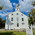
Blawenburg Reformed Church
-
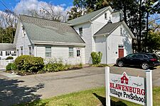
Blawenburg Village Preschool
-
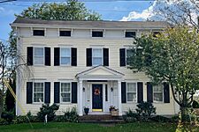
William Sherman House


See also
 In Spanish: Blawenburg para niños
