Blaxland County facts for kids
Quick facts for kids BlaxlandNew South Wales |
|||||||||||||||
|---|---|---|---|---|---|---|---|---|---|---|---|---|---|---|---|

Location in New South Wales
|
|||||||||||||||
|
|||||||||||||||
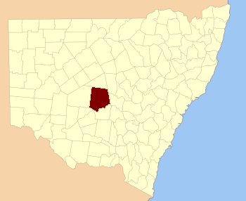
Blaxland County is one of the 141 special areas in New South Wales, Australia. These areas are called cadastral divisions. They are used for keeping track of land ownership and boundaries. Think of them like big, old-fashioned land maps!
This county is located in the western part of New South Wales. Its southern edge follows the Lachlan River. A smaller stream called Waverley Creek also forms part of its boundary. Inside Blaxland County, you'll find places like Mount Hope. It also includes the Nombinnie Nature Reserve, which is a protected area for nature.
Who Was Blaxland County Named After?
Blaxland County was named to honor a very important person. His name was John Blaxland. He was a famous landowner and a merchant. This means he owned a lot of land and was involved in trading goods.
Exploring Blaxland County
Blaxland County is quite large. It is made up of many smaller areas called parishes. These parishes help organize the land even more. Some of these parishes are part of the Cobar Shire. Others are in the Carrathool Shire. These shires are like local government areas. They help manage the communities and services in the region.
The Nombinnie Nature Reserve is a special part of Blaxland County. It is a protected area. This means it helps keep the natural environment safe. It is home to many different plants and animals. People visit nature reserves to enjoy the outdoors. They can also learn about Australia's unique wildlife.

