Mossgiel County facts for kids
Quick facts for kids MossgielNew South Wales |
|||||||||||||||
|---|---|---|---|---|---|---|---|---|---|---|---|---|---|---|---|

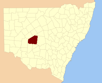
Location in New South Wales
|
|||||||||||||||
|
|||||||||||||||
Mossgiel County is a special type of area in New South Wales, Australia. It's one of 141 "cadastral divisions" in the state. These divisions are like old-fashioned land boundaries used for maps and official records.
The southern border of Mossgiel County is marked by Waverley Creek. A place called Trida is also located within this county. It seems that Mossgiel County got its name from a nearby property known as Mossgiel Station.
Contents
What is a Cadastral County?
A cadastral county is not like the counties you might hear about in other countries. In Australia, especially in New South Wales, these counties were created a long time ago. They helped surveyors and governments keep track of land ownership.
Why are these divisions important?
These land divisions were very useful when Australia was first being settled. They helped people understand who owned what land. They also made it easier to sell land and collect taxes. Even today, these old boundaries are sometimes used for legal documents.
Parishes in Mossgiel County
Inside each county, there are smaller areas called "parishes." These are even smaller land divisions. They help to break down the county into more manageable parts. Each parish has its own name and location.
How are parishes used today?
While not used for everyday addresses, parishes are still important for land titles. They help to describe exactly where a piece of land is located. This is especially true for rural areas.
- Some parishes in Mossgiel County include:
- Barrigan
- Bennett
- Berriganbam
- Bevan
- Billabah
There are many more parishes within Mossgiel County. Each one is part of a larger Local Government Area (LGA). These LGAs are the modern way of dividing land for local councils.

