Blenheim Reef facts for kids
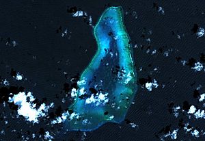
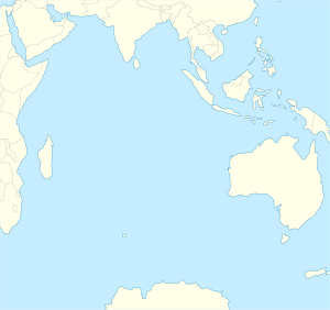
Blenheim Reef is a special kind of atoll in the Chagos Archipelago. This group of islands is found in the Indian Ocean. An atoll is a ring-shaped coral reef that partly surrounds a lagoon (a shallow body of water).
Blenheim Reef is partly underwater. It includes a coral reef called Baxio Predassa on its southeast side. There's also another part that is completely hidden underwater. The reef is in the northeast part of the Chagos Archipelago.
The atoll is quite large. It stretches almost 11 kilometres from north to south. It is also more than 4 kilometres wide from east to west. Its total area is about 36.8 square kilometres. This includes the lagoon, which is 8.5 square kilometres. The rest is mostly flat reef.
Only a few sand islands, called cays, rise above the water. These are found on the eastern side. The biggest island is East Island. It is almost 200 metres long and 70 metres wide. The other small islands are North, Middle, and South. Only a few types of grass grow on these islands.
The lagoon inside the reef can be up to 18 metres deep. It has many rocks. The coral reef around the edge has a wide opening in the southwest. The closest land is Takamaka Island. This island is part of the Salomon Islands Atoll. It is about 20 kilometres southwest of Blenheim Reef.
History of Blenheim Reef
People believe that Portuguese sailors first found this atoll around the year 1570. Because of this, it is also known by its Portuguese name, Baxio Predassa. This name is a changed version of "Baixo Predassa."
The name "Blenheim" comes from a ship called the Blenheim. This ship discovered the reef on May 5, 1836. It was on a journey from London to Bombay (now Mumbai). A letter from James Temple Brown in the Nautical Magazine and Naval Chronicle in 1837 tells this story.
From 1845 to 1860, people tried to mine guano and phosphate here. Guano is bird droppings, and phosphate is a mineral. Both are used as fertilizer. But this work stopped because it was too hard to transport the materials.
Around 1880, a company called the Indian Ocean Fruit Company tried to grow palm trees on the island. Sadly, a big storm washed all the young palm trees into the sea.
On June 29, 1975, Blenheim Reef became part of the Chagos Archipelago. At that time, Mauritius claimed the atoll as its own. Before this date, no country had officially claimed it.
Over the years, many ships have been wrecked around Blenheim Reef. In total, 57 ships have sunk there. It is thought that about 200 lives were lost in these shipwrecks.
Islands of Blenheim Reef
Baxio Predassa is the name given to the islands that stick out from the eastern side of the reef. When Robert Moresby first explored the area, there were many more islands in Baxio Predassa. However, over time, these islands have been worn away by the sea or have sunk underwater. Today, only four small islands remain.
The group of islands today includes:
- Ile du Nord: This is the island furthest to the north.
- Ile du Milieu: This island is surrounded by a reef.
- Ile de l'Est: This is the largest island and the one furthest to the east in the atoll. Only grasses grow on this island now. There was once an attempt to plant palm trees here, but it was not successful.
- Ile du Sud: This is the smallest island and the one furthest to the south. It has no plants growing on it and is not very important.
See also
 In Spanish: Arrecife Blenheim para niños
 | May Edward Chinn |
 | Rebecca Cole |
 | Alexa Canady |
 | Dorothy Lavinia Brown |


