Bloomingdale, Ohio facts for kids
Quick facts for kids
Bloomingdale, Ohio
|
|
|---|---|
|
Village
|
|

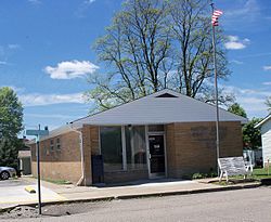
Bloomingdale Post Office
|
|

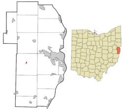
Location of Bloomingdale in Jefferson County and in the state of Ohio
|
|
| Country | United States |
| State | Ohio |
| County | Jefferson |
| Township | Wayne |
| Area | |
| • Total | 0.09 sq mi (0.23 km2) |
| • Land | 0.09 sq mi (0.23 km2) |
| • Water | 0.00 sq mi (0.00 km2) |
| Elevation | 1,260 ft (380 m) |
| Population
(2020)
|
|
| • Total | 145 |
| • Estimate
(2023)
|
135 |
| • Density | 1,647.73/sq mi (633.58/km2) |
| Time zone | UTC-5 (Eastern (EST)) |
| • Summer (DST) | UTC-4 (EDT) |
| ZIP code |
43910
|
| Area code(s) | 740 |
| FIPS code | 39-07202 |
| GNIS feature ID | 2398137 |
Bloomingdale is a small village in Ohio, United States. It is located in the central part of Jefferson County. In 2020, about 145 people lived there.
Bloomingdale is part of a larger area called the Weirton–Steubenville metropolitan area. It is also home to a special religious community called Holy Family Hermitage. This community is part of the Congregation of Monte Corona.
Contents
History of Bloomingdale Village
Bloomingdale was first planned out in 1816. When it was first created, it was called Bloomfield. A post office has been operating in Bloomingdale since 1822.
Geography of Bloomingdale
Bloomingdale is a very small village. It covers about 0.23 square kilometers (0.09 square miles) of land. There is no water area within the village limits.
Population and People
Bloomingdale has seen its population change over the years. Here's a look at how many people have lived in the village:
| Historical population | |||
|---|---|---|---|
| Census | Pop. | %± | |
| 1850 | 184 | — | |
| 1870 | 146 | — | |
| 1880 | 175 | 19.9% | |
| 1890 | 173 | −1.1% | |
| 1900 | 189 | 9.2% | |
| 1910 | 185 | −2.1% | |
| 1920 | 191 | 3.2% | |
| 1930 | 265 | 38.7% | |
| 1940 | 339 | 27.9% | |
| 1950 | 324 | −4.4% | |
| 1960 | 284 | −12.3% | |
| 1970 | 289 | 1.8% | |
| 1980 | 254 | −12.1% | |
| 1990 | 227 | −10.6% | |
| 2000 | 221 | −2.6% | |
| 2010 | 202 | −8.6% | |
| 2020 | 145 | −28.2% | |
| 2023 (est.) | 135 | −33.2% | |
| U.S. Decennial Census | |||
2010 Census Information
In 2010, there were 202 people living in Bloomingdale. These people lived in 80 different homes. Most of these homes (60) were families.
The village had about 2,244 people per square mile. There were 86 housing units in total. Most residents (98%) were White. A small number were African American or Native American. Some residents were from two or more racial backgrounds.
About 26% of homes had children under 18 living there. More than half (56%) were married couples. The average household had about 2.5 people. The average family had about 2.8 people.
The average age of people in the village was 41.5 years. About 19% of residents were under 18. About 14% were 65 years old or older. Slightly more than half (53%) of the residents were male.
Education in Bloomingdale
Students in Bloomingdale attend public schools. These schools are part of the Indian Creek Local School District.
See also
 In Spanish: Bloomingdale (Ohio) para niños
 | James Van Der Zee |
 | Alma Thomas |
 | Ellis Wilson |
 | Margaret Taylor-Burroughs |

