Boot Heel volcanic field facts for kids
Quick facts for kids Boot Heel volcanic field |
|
|---|---|

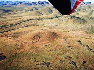
Volcanic vent at the head of the lava flow west of Animas, New Mexico at the base of the Peloncillo Mountains.
|
|
| Highest point | |
| Elevation | 2,300 m (7,500 ft) |
| Geography | |
| Location | Mexico–United States border |
| Geology | |
| Age of rock | 3.2 to 0.3 million years |
| Mountain type | volcanic field |
The Boot Heel volcanic field is a large area in the southwestern United States and northwestern Mexico where many volcanoes have erupted over millions of years. It covers a huge space, more than 24,000 square kilometers! That's bigger than some small countries.
This volcanic field is found in the "Bootheel" part of New Mexico, and also stretches into southeastern Arizona and parts of Mexico. It's home to nine giant calderas, which are like huge bowls left behind after a volcano erupts and collapses. These calderas formed between 26.9 and 35.3 million years ago.
When these volcanoes erupted, they produced different kinds of rock. This includes rhyolite ignimbrites (which are rocks formed from hot ash flows), along with basalt, andesite, and rhyolite lava flows. Some of the ash flows were enormous, filling valleys with 35 to 650 cubic kilometers of material!
The Boot Heel volcanic field also includes smaller volcanic areas like the Geronimo-Animas volcanic field and the Palomas volcanic field.
What is a Volcanic Field?
A volcanic field is a region with many small volcanoes or vents instead of just one large volcano. Think of it like a scattered group of smaller volcanoes rather than a single giant mountain. These fields can be active for millions of years, with eruptions happening in different spots over time.
The Geronimo Volcanic Field
The Geronimo volcanic field is a part of the larger Boot Heel volcanic field. It's also known as the San Bernardino volcanic field. This area is a monogenetic volcanic field. This means that each volcano in the field usually erupts only once. After that single eruption, it becomes inactive, and new eruptions happen at different spots nearby.
Giant Calderas of the Boot Heel Field
The Boot Heel volcanic field is famous for its large calderas. A caldera is a big, bowl-shaped hollow that forms when the ground collapses after a huge volcanic eruption empties the magma chamber below. Here are some of the main calderas found in this field and when they formed:
- In the Pyramid Mountains:
* Muir caldera: Formed 35.3 million years ago.
- In the Peloncillo Mountains:
* Steins caldera: Formed 34.4 million years ago.
- In the Animas Mountains:
* Juniper caldera: Formed 33.5 million years ago. * Animas Peak caldera: Formed 33.5 million years ago. * Tullous caldera: Formed 35.1 million years ago.
- In the Chiricahua Mountains:
* Geronimo Trail caldera: Formed 32.7 million years ago. * Clanton Draw caldera: Formed 27.4 million years ago. * Portal caldera: Formed 27.6 million years ago. * Turkey Creek caldera: Formed 26.9 million years ago.
These calderas show just how powerful the volcanic activity was in this region millions of years ago!
 | James B. Knighten |
 | Azellia White |
 | Willa Brown |

