
Chiricahua Mountains facts for kids
Quick facts for kids Chiricahua Mountains |
|
|---|---|

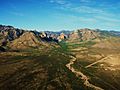
Chiricahua Mountains - northeast flank (from Portal, AZ)
|
|
| Highest point | |
| Peak | Chiricahua Peak |
| Elevation | 9,759 ft (2,975 m) |
| Dimensions | |
| Length | 35 mi (56 km) NW, then SW |
| Width | 21 mi (34 km) (arc-shape)-N-S |
| Geography | |

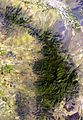
Location in Arizona
|
|
| Country | United States |
| Communities | Willcox, Douglas, Rodeo and Portal |
| Range coordinates | 31°55′47″N 109°22′56″W / 31.9298117°N 109.3822849°W |
The Chiricahua Mountains are a large mountain range in southeastern Arizona. They are part of a bigger area called the Basin and Range province in the western United States and Mexico. These mountains are also part of the Coronado National Forest.
The highest point in the range is Chiricahua Peak. It stands 9,759 feet (2,975 m) (about 2,975 meters) above sea level. This is about 6,000 feet (1,800 m) (1,800 meters) higher than the valleys around it. The mountains get their name from the Chiricahua Apaches, who were the native people of this area.
The Chiricahua Mountains are in the eastern part of Cochise County. Nearby ranges include the Pedregosa Mountains to the south and the Swisshelm Mountains to the southwest. To the northwest, the mountains connect to the Dos Cabezas Mountains.
You can reach the Chiricahua Mountains from different towns. Willcox is to the north, Douglas is to the south, and Rodeo is to the east. Most of the range is part of the 87,700-acre (35,500 ha) Chiricahua Wilderness, which is a protected area.
Contents
Discovering the Chiricahua Mountains' Past
The Chiricahua Mountains have a long and interesting history. The earliest signs of people living here are from the Clovis culture. These ancient sites, like Double Adobe, are found in the Whitewater Draw area.
Later, the Cochise tradition culture lived here from about 3000 BCE to 200 BCE. They were known for their tools made without pottery. After that, people started using pottery. You can find artifacts from the Mogollon culture and its local Mimbres culture, dating from 150 BCE to 1450 CE.
Later, other indigenous peoples arrived, including the Chiricahua Apaches. Famous leaders like Cochise and Geronimo lived in these mountains. They stayed until they were moved from the area in the late 1800s.
The name "Chiricahua" likely comes from the Opata language. Chiwi Kawi means "Turkey Mountain." This is because there used to be many wild turkeys in the area.
Mining also played a role in the mountains' history. The first mining claim was made in 1881. Mining continued off and on, with busy times in the 1920s and 1950s.
Understanding the Chiricahua Mountains' Geology

The Chiricahua Mountains are a raised block of land, part of the Basin and Range province. The mountains have very old rocks from the Precambrian era. They also have Paleozoic and Cretaceous sedimentary rocks.
About 35 to 25 million years ago, there were huge volcanic eruptions here. The last big eruption, 27 million years ago, created the Turkey Creek Caldera. This eruption covered the area with 2,000 feet (610 m) (about 610 meters) of volcanic ash. This ash hardened into a type of rock called welded rhyolite tuff.
Over time, wind and water have worn away these rocks. This erosion created amazing stone spires and columns, also known as hoodoos. These cool rock formations stick up out of the forest. You can see many of them in the Chiricahua National Monument. They are made of Rhyolite Canyon Tuff.
There's also a band of sedimentary rock that runs through the mountains. This area has many mineral deposits. The largest mine in this area was the Hilltop mine, which had tunnels totaling 6,098 metres (20,007 ft) (about 3.8 miles).
Exploring the Chiricahua Mountains' Wildlife and Plants

The Chiricahua Mountains are a very special place for nature. They are known as a "sky island" because they are tall, isolated mountains surrounded by desert. This means they have many different kinds of plants and animals.
Five of the nine main "life zones" (areas with similar plants and animals) can be found here. Over 375 types of birds have been seen in the Chiricahua Mountains! Many of these birds are usually found in Mexico, and southern Arizona is the northern edge of their homes.
Other interesting animals living here include ocelots, jaguars, mountain lions, nine-banded armadillos, black bears, and white-tailed deer.
The base of the Chiricahua Mountains is about 3,600 feet (1,100 m) (1,100 meters) high. The range goes up about 6,000 feet (1,800 m) (1,800 meters) from there. At the bottom, you'll find grasslands and desert plants. As you go higher, you'll see ponderosa pine and Douglas fir trees.
On the east side of the mountains is Cave Creek Canyon. This area is home to the American Museum of Natural History Southwest Research Station. There are also small towns nearby, like Portal and Paradise.
Unique Species of the Chiricahua Mountains
|
|
Images for kids
-
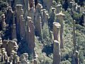
Hoodoos, Chiricahua National Monument
-
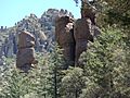
Trees and hoodoos, Chiricahua National Monument
-
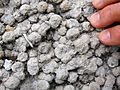
Spherulites
-
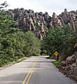
Road to Chiricahua National Monument
-
Sunglow Ranch
-
Cave Creek Canyon
-
Chiricahua Mountain Range (massif), and its sub-Ranges, with the bordering valleys.


See also
 In Spanish: Sierra de Chiricahua para niños
