Chiricahua Peak facts for kids
Quick facts for kids Chiricahua Peak |
|
|---|---|

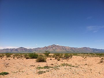
View of the Chiricahua Mountains from the Painted Pony Resort in Rodeo, NM.
|
|
| Highest point | |
| Elevation | 9,763 ft (2,976 m) NAVD 88 |
| Prominence | 5,139 ft (1,566 m) |
| Listing |
|
| Geography | |
| Location | Cochise County, Arizona, U.S. |
| Parent range | Chiricahua Mountains |
| Topo map | USGS Chiricahua Peak |
| Geology | |
| Age of rock | 27 Ma |
| Mountain type | Volcanic |
Chiricahua Peak is a tall mountain in the Chiricahua Mountains of southeastern Arizona. It stands about 9,763 feet (2,976 m) high. This makes it the tallest point in the Chiricahua Mountains. It is also the highest spot in Cochise County. The peak is about 35 miles (56 km) north of the United States–Mexico border.
Contents
How Was Chiricahua Peak Formed?
Chiricahua Peak was created by a powerful volcanic eruption. This happened about 27 million years ago. The entire Chiricahua Mountains range was formed this way.
What Plants Grow on Chiricahua Peak?
This peak is home to some special trees. You can find Engelmann spruce trees here. These are some of the southernmost Engelmann spruce stands in the world. There are also many aspen trees growing on the north side of the mountain.
What Views Can You See From the Peak?
A large fire recently burned much of the peak. This fire created wide-open views across the landscape. You can see far across the Basin and Range area. From the peak, you might spot Mount Lemmon, Mount Graham, and Mount Wrightson. You can also see Willcox Playa, which is a large dry lakebed below.
What Was the Horseshoe 2 Fire?
In 2011, a big wildfire called the Horseshoe 2 Fire happened. It burned about 223,000 acres (90,000 ha) in the Chiricahua Mountains. This fire caused a lot of damage to the hiking trails.
 | Percy Lavon Julian |
 | Katherine Johnson |
 | George Washington Carver |
 | Annie Easley |


