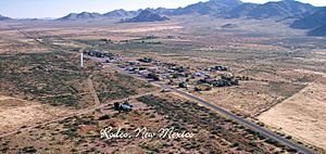
Rodeo, New Mexico facts for kids
Quick facts for kids
Rodeo, New Mexico
|
|
|---|---|
 |
|
| Country | United States |
| State | New Mexico |
| County | Hidalgo |
| Area | |
| • Total | 8.19 sq mi (21.22 km2) |
| • Land | 8.19 sq mi (21.22 km2) |
| • Water | 0.00 sq mi (0.00 km2) |
| Elevation | 4,124 ft (1,257 m) |
| Population
(2020)
|
|
| • Total | 108 |
| • Density | 13.18/sq mi (5.09/km2) |
| ZIP Code |
88056
|
| Area code(s) | 575 |
| FIPS code | 35-64370 |
| GNIS feature ID | 2584194 |
Rodeo is a small community in Hidalgo County, New Mexico, United States. It's called a "census-designated place" (CDP) because it's a special area defined for counting people. Rodeo is very close to the border with Arizona, less than 1 mile (about 1.6 km) away. You can find it along New Mexico State Road 80. In 2010, about 101 people lived in Rodeo. By 2020, the population had grown slightly to 108 people.
Contents
History of Rodeo, New Mexico
Rodeo was started in 1902. It began as a stop for trains on the El Paso and Southwestern Railroad line. This railway connected Bisbee, Arizona to El Paso, Texas.
Rodeo's Role in Cattle Shipping
The town quickly became an important place for shipping cattle. Ranchers in the San Simon Valley would bring their cattle here. From Rodeo, the cattle could be sent by train to other places.
What Does "Rodeo" Mean?
The name "Rodeo" comes from a Spanish word. In Spanish, rodeo means "roundup" or "enclosure." It specifically refers to a "place where cattle are gathered." The word comes from the Spanish verb rodear, which means "to surround" or "to encircle."
The Railroad's Path
The El Paso and Southwestern railroad line was very important for Rodeo. It traveled east across the southern part of New Mexico. After going through Antelope Pass, it turned south towards Rodeo. From Rodeo, the train line continued to Douglas, Arizona, and then north to Bisbee. This route went around the Chiricahua Mountains.
Geography of Rodeo
Rodeo is located in the western part of Hidalgo County. It shares a border with the state of Arizona.
Highways and Nearby Towns
New Mexico Highway 80 runs through Rodeo. If you go north on Highway 80 for about 30 miles (48 km), you will reach Interstate 10 at Road Forks. If you travel southwest on Highway 80 for about 2 miles (3.2 km), you will cross into Arizona. The road then becomes Arizona State Route 80 and continues for another 48 miles (77 km) to Douglas, Arizona. Lordsburg, which is the main town for Hidalgo County, is about 47 miles (76 km) northeast of Rodeo. You can get there by taking Highway 80 and then Interstate 10.
Land Area
According to the U.S. Census Bureau, the area of Rodeo is about 8.19 square miles (21.2 square kilometers). All of this area is land; there is no water within the community's boundaries.
Population and People
The study of how many people live in a place, and what they are like, is called demographics.
Population Changes
The number of people living in Rodeo has changed over time.
| Historical population | |||
|---|---|---|---|
| Census | Pop. | %± | |
| 2020 | 108 | — | |
| U.S. Decennial Census | |||
In 2010, the population was 101 people. By the year 2020, the population had increased slightly to 108 people.
See also
 In Spanish: Rodeo (Nuevo México) para niños
 | Bayard Rustin |
 | Jeannette Carter |
 | Jeremiah A. Brown |


