
Chiricahua National Monument facts for kids
Quick facts for kids Chiricahua National Monument |
|
|---|---|
|
IUCN Category V (Protected Landscape/Seascape)
|
|

The Balanced Rock formation
|
|

Chiricahua National Monument
Location in Arizona

Chiricahua National Monument
Location in the United States
|
|
| Location | Cochise County, Arizona, United States |
| Nearest city | Willcox, Arizona |
| Area | 11,984 acres (48.50 km2) |
| Created | April 18, 1924 |
| Visitors | 60,577 (in 2018) |
| Governing body | National Park Service |
| Website | Chiricahua National Monument |
Chiricahua National Monument is a special place in southeastern Arizona. It is part of the National Park System. This monument is located in the Chiricahua Mountains.
It was created on April 18, 1924. Its main purpose is to protect amazing rock formations. These include tall, thin 'hoodoos' and 'balancing rocks'. You can also find the historic Faraway Ranch here. It was once home to Swedish immigrants Neil and Emma Erickson. Most of the monument (85%) is a protected wilderness area. This means it's kept wild and natural.
Visiting Chiricahua National Monument
When you visit, stop by the Visitor Center! It's just two miles from the park entrance. Inside, you'll find cool exhibits. They teach you about the rocks, nature, and history of the area. Friendly park rangers are there to help. They can give you trail maps and answer your questions.
There are about 17 miles (27 km) of trails. You can hike through meadows, forests, and amazing rock formations. A free shuttle bus leaves the Visitor Center every morning at 9:00 AM. It takes hikers to popular trail starting points. These include Echo Canyon or Massai Point. You can then hike back to the Visitor Center on marked trails.
How the Rocks Were Formed
Chiricahua National Monument is about 36 miles (58 km) southeast of Willcox, Arizona. The monument protects the remains of a huge volcanic eruption. This eruption happened about 27 million years ago. Hot ash shot out from a nearby volcano called the Turkey Creek Caldera.
This ash cooled and hardened into a type of rock called rhyolitic tuff. It formed a layer almost 2,000 feet (610 m) thick. Over millions of years, wind and water slowly carved this rock. This erosion created the unique rock formations you see today. These include the famous hoodoos and balancing rocks.
In 2008, a large part of the monument was recognized as a historic landscape. It's called the Chiricahua National Monument Historic Designed Landscape. This means its natural beauty and design are very important.
Climate
The weather at Chiricahua National Monument changes with the seasons. Summers can be hot, especially in June and July. Temperatures often reach into the 90s Fahrenheit (30s Celsius). Winters are cooler, with average highs in the 50s Fahrenheit (10s Celsius). It can get quite cold at night, sometimes below freezing.
The monument gets most of its rain in the summer. This is usually during July and August. These are often short, strong thunderstorms. Snowfall can happen in the winter months. January and December usually see the most snow. The climate helps different plants and animals live here.
| Climate data for Chiricahua National Monument, AZ | |||||||||||||
|---|---|---|---|---|---|---|---|---|---|---|---|---|---|
| Month | Jan | Feb | Mar | Apr | May | Jun | Jul | Aug | Sep | Oct | Nov | Dec | Year |
| Record high °F (°C) | 80 (27) |
80 (27) |
86 (30) |
93 (34) |
104 (40) |
108 (42) |
109 (43) |
103 (39) |
100 (38) |
95 (35) |
85 (29) |
82 (28) |
109 (43) |
| Mean daily maximum °F (°C) | 56.2 (13.4) |
59.1 (15.1) |
64.7 (18.2) |
72.8 (22.7) |
81.5 (27.5) |
90.5 (32.5) |
89.2 (31.8) |
86.1 (30.1) |
83.5 (28.6) |
75.2 (24.0) |
64.1 (17.8) |
56.7 (13.7) |
73.3 (23.0) |
| Mean daily minimum °F (°C) | 29.9 (−1.2) |
31.2 (−0.4) |
34.4 (1.3) |
39.4 (4.1) |
46.2 (7.9) |
55.2 (12.9) |
59.9 (15.5) |
58.9 (14.9) |
55.0 (12.8) |
45.9 (7.7) |
35.7 (2.1) |
30.2 (−1.0) |
43.5 (6.4) |
| Record low °F (°C) | −10 (−23) |
8 (−13) |
10 (−12) |
20 (−7) |
19 (−7) |
35 (2) |
40 (4) |
44 (7) |
33 (1) |
21 (−6) |
8 (−13) |
−1 (−18) |
−10 (−23) |
| Average precipitation inches (mm) | 1.45 (37) |
1.20 (30) |
1.17 (30) |
0.47 (12) |
0.34 (8.6) |
0.84 (21) |
4.00 (102) |
4.05 (103) |
1.70 (43) |
1.17 (30) |
1.03 (26) |
1.61 (41) |
19.03 (483.6) |
| Average snowfall inches (cm) | 2.9 (7.4) |
1.7 (4.3) |
1.7 (4.3) |
0.3 (0.76) |
0 (0) |
0 (0) |
0 (0) |
0 (0) |
0 (0) |
0.1 (0.25) |
0.7 (1.8) |
2.9 (7.4) |
10.3 (26.21) |
| Source: https://wrcc.dri.edu/cgi-bin/cliMAIN.pl?az1664 | |||||||||||||
Images for kids
-
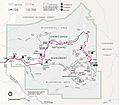
Park map
-
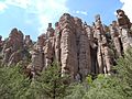
Stone columns, called hoodoos, are the most common formation in the monument
-
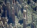
Hoodoos in Totem Canyon
-

180° panoramic view of Chiricahua National Monument


