
Bosnia (region) facts for kids
Quick facts for kids
Bosnia
Bosna
Босна |
|
|---|---|
|
Region
|
|

Approximate borders between two modern-day regions of Bosnia and Herzegovina - Bosnia (marked dark brown) and Herzegovina (marked light brown)
|
|
| Country | Bosnia and Herzegovina |
| Largest cities | Sarajevo, Banja Luka |
| Area | |
| • Total | 39,021 km2 (15,066 sq mi) |
| Population
(2013)
|
c. 2 million |
| Demonym(s) | Bosnian |
| Time zone | UTC+1 (CET) |
| • Summer (DST) | UTC+2 (CEST) |
Bosnia (called Bosna in Bosnian) is the main northern part of the country Bosnia and Herzegovina. It covers about 81% of the country's land. The other part, in the south, is called Herzegovina.
Bosnia and Herzegovina have been connected for a very long time, even since the Middle Ages. Often, when people say "Bosnia," they are talking about both regions together. The full name "Bosnia and Herzegovina" only became official later, during the time of the Ottoman Empire.
Contents
Geography of Bosnia
Bosnia is mostly covered by the Dinaric Alps, which are mountain ranges. It also reaches the southern edges of the Pannonian plain, which is a large flat area. The Sava River forms its northern border, and the Drina River marks its eastern border.
The region of Bosnia is about 39,021 square kilometers. This makes up around 80% of the country Bosnia and Herzegovina. There isn't a clear, official line between Bosnia and Herzegovina. People often say Herzegovina is south of the Ivan planina mountain. Another idea is that Herzegovina includes the areas where the Neretva River and Trebišnjica River flow.

A Brief History of Bosnia
The central part of Bosnia was home to early farmers during the Stone Age. These people belonged to cultures like the Kakanj culture and later the Butmir culture. Later, people from the Vučedol culture arrived during the Copper Age.
During the Bronze Age and Iron Age, different groups lived here, like the Central Bosnian cultural group and Glasinac culture. The Daesitiates, an Illyrian tribe, became very important in these areas.
We don't have many written records from the earliest times. The first known ruler of Bosnia was Ban Borić, who was appointed in 1154.
An old book called De Administrando Imperio mentions a small area called Bosona. This area was located around the Bosna River, near where the cities of Sarajevo and Visoko are today.
Under its first ruler known by name, Stephen, Duke of Bosnia, in the 1080s, the region included the upper parts of the Bosna, Vrbas, and Neretva rivers.

By the end of the 14th century, under Tvrtko I of Bosnia, the Bosnian kingdom grew very large. It covered most of what is now Bosnia and also the area that would later be known as Herzegovina.
In 1463, the kingdom lost its independence and became part of the Ottoman Empire. The city of Jajce was the westernmost city of Bosnia when the Ottomans took over.
The Ottomans first expanded into Bosnia and Herzegovina through a territory called the Bosansko Krajište. After 1462/1463, it became the Sanjak of Bosnia and the Sanjak of Herzegovina. The first Ottoman government, called the Eyalet of Bosnia, was formed in 1527. This happened after a long fight against local leaders like Counts Franjo and Ivaniš Berislavić.
After a big war called the Great Turkish War, in the 18th century, the Eyalet of Bosnia grew to include almost all of today's Bosnia and Herzegovina.
In 1833, the region of Herzegovina was briefly separated under Ali-paša Rizvanbegović. After he died, the area officially became known as "Bosnia and Herzegovina" in 1853. In 1864, it was renamed the Vilayet of Bosnia. Then, in 1878, Austria-Hungary took control of the entire country. It was still officially part of the Ottoman Empire until 1908. That year, Austria-Hungary officially took over the province, which caused a political event known as the Bosnian crisis.
What is Bosnian Identity?
Within Bosnia and Herzegovina, the region of Bosnia has its own special identity. This is different from the identity of the neighboring region, Herzegovina. People started recognizing a Bosnian identity as early as the 10th century. At that time, a writer named Constantin VII Porphyrogenetos wrote about Bosnia as a unique region.
This regional identity continued to grow throughout the Middle Ages. Even the Ottoman conquerors in the 15th century recognized it. They created the Sanjak of Bosnia in 1463 and gave it a regional name, which was not always done. By the end of Ottoman rule in 1878, being "Bosnian" became a strong part of local identity. This feeling of being Bosnian was shared by people of different backgrounds and religions. It stayed strong through the times of Austro-Hungarian rule (1878-1918) and Yugoslav rule (1918-1992).
Parts of Bosnia
Bosnia is made up of several smaller areas, each with its own character:
- Podrinje, in the eastern part
- Bosanska Krajina, in the northwestern part
- Central Bosnia, in the middle of the region
- Posavina, in the very north
- Semberija, in the northeastern part
- Tropolje, in the western part
Gallery
-
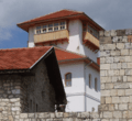
Gradačac - City castle
-
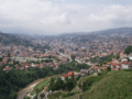
Sarajevo - View from east.
-

Franciscan monastery in Fojnica
-
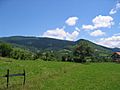
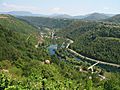
Mountains in Bosnia
-
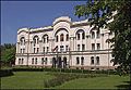
Banski dvor in Banja Luka
-
Una River - (view from Brekovica)


See also
 In Spanish: Bosnia (región) para niños
