Bourke Isles facts for kids

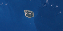
A Landsat image of Yam Island, one of the Bourke Isles
|
|

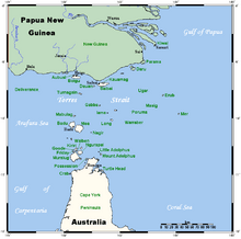
A map of the Torres Strait Islands showing Yam Island as Iama in central waters of the Torres Strait
|
|
| Etymology | Richard Bourke |
|---|---|
| Geography | |
| Location | Cumberland Passage, Northern Australia |
| Coordinates | 9°54′00″S 143°23′41″E / 9.8999°S 143.3947°E |
| Archipelago | Torres Strait Islands |
| Adjacent bodies of water | Torres Strait |
| Major islands | Yam Island |
| Administration | |
| State | Queensland |
| Local government area | Torres Strait Island Region |
| Demographics | |
| Ethnic groups | Torres Strait Islanders |
The Bourke Isles are a group of small islands and tiny islets. They are part of the larger Torres Strait Islands group. These islands are located in the Torres Strait, west of a waterway called the Cumberland Passage. The Bourke Isles are part of the state of Queensland, Australia.
These islands are about 130 kilometers (80 miles) northeast of Thursday Island. They are also about 54 kilometers (33 miles) southwest of Darnley Island. The Bourke Isles include seven small islands or islets. They are all located within the Torres Strait Island Region. This region is a local government area in Queensland.
Contents
What are the Bourke Isles?
The Bourke Isles are made up of several named islands and islets. An islet is a very small island.
Here are some of the islands in the group:
- Aukane Islet
- Aureed Island
- Bourke Island
- Kabbikane Islet
- Layoak Islet
- Mimi Islet
- Roberts Islet
- Yam Island
History of the Islands
The Bourke Isles were named in the middle of 1836. Charles Lewis, who was the Commander of the schooner Isabella, named them. The Isabella was a ship from the Colony of New South Wales. Commander Lewis named the islands to honor Richard Bourke. At that time, Richard Bourke was the Governor of New South Wales.
The Charles Eaton Shipwreck and Rescue
In June 1836, the ship Isabella was sent from Sydney. Its mission was to search for people who had survived a shipwreck. The ship they were looking for was the barque Charles Eaton. This ship had been wrecked on the Great Detached Reef on August 15, 1834. This reef is part of the Great Barrier Reef.
Most of the crew and passengers from the Charles Eaton had survived the wreck. They sailed on rafts to the Torres Strait. Sadly, many were killed by Torres Strait Islanders from Mer. However, a young cabin boy and a baby boy were saved. They lived with the Mer people for two years.
Captain Lewis and his crew rescued these two survivors. After the rescue, Captain Lewis explored some nearby islands. He learned that some items from the shipwreck had been taken to Aureed Island.
Exploring Aureed Island
Captain Lewis went to explore a group of small islands. He called them the "Six Sisters." Aureed was one of these islands. His armed men went onto Aureed Island. They found it empty, and the village was abandoned.
The men found a damaged shed. Inside, they found a large mask made from a decorated turtle shell. It was surrounded by some human skulls. This was later identified as a special place used by a local group. Captain Lewis and his men took the skulls and the mask. They then set fire to the village and everything else on the island, including tobacco plants. Captain Lewis called the island "Skull Island," but this name was not used later.
 | Tommie Smith |
 | Simone Manuel |
 | Shani Davis |
 | Simone Biles |
 | Alice Coachman |


